

I know a chap who's idea of showing off Lawton at its finest involves encouraging people to gaze at the city with a big smile in their hearts, as the city grows more faint in their rearview mirror.

 Participating Member

I know a chap who's idea of showing off Lawton at its finest involves encouraging people to gaze at the city with a big smile in their hearts, as the city grows more faint in their rearview mirror.
VIP Member
You won't find anything about that or many other hikes on any official maps or websites.Originally Posted by namellac

Amazon.com: Outdoor and Trail Guide to the Wichita Mountains of Southwest Oklahoma: Books: Edward C. Ellenbrook
site forthe outdoor trail guide valley of thewichitas
Andrew Stewart
Thank you very much, my friend.
Participating Member
If nothing else, find yourself at the northside of the Elk Mountain Boulder field, looking south.
VIP Member
If anyone said anything about the drive up Mt. Scott, I missed it. It's a great drive with a good overlook at the top. Treasure Lake is a small but exceptionally beautiful lake on the west side of the refuge ... it was gorgeous and, I hope, still is!
Many things have radically changed since I was a kid growing up in Lawton (LHS 1961) ... serious over-regulation today prevents camping and swimming in areas originally intended for such ... Lake Elmer Thomas was a great place to swim and Quannah Parker wasn't bad either ... Camp Boulder was a great place to camp. If you follow the little creek running along its southern side westerly, you wind up in a small but beautiful canyon called "The 40 Foot Hole." If you follow the creek easterly (serious climbing involved to do this) you eventually wind up at a beautiful swimming hole surrounded by cliffs.
"Craterville" was a neat little amusement park just north of Cache toward the Wichitas entrance ... on land now owned by Ft. Sill. From AMUSEMENT PARKS ...
And, as others have already said, there's nothing like a Meers Burger! Just a little south of Meers, if one crawled under a fence into a restricted area, one could climb up the mountain (may be Elk Mountain, I don't recall for sure) into former mining areas ... while the mine shafts were all destroyed, one could find artifacts from that period ... if one went where one was not supposed to. Of course, I never did that myself!Southwestern Oklahoma also had many places for young and old to go for thrills. Craterville, named for a meteor crater in the Wichita Mountains, existed in the present-day Wichita Mountains Wildlife Refuge. After the refuge took over the land, the park moved to a location two miles east of Lugert. Besides having the usual amusement park amenities, Craterville hosted rodeos and the All-Indian Fair and Exposition that began in 1924 and moved to Anadarko in 1935 as the American Indian Exposition. Craterville closed in the mid-1950s, and the land was bought by Fort Sill.
I had some really grand times in the Wichitas as a kid, too many to count. Very very good memories!
VIP Member
Very nice info Doug. Where exactly was Camp Boulder?
Participating Member
Yes, thanks Doug!! The Wichita Mts. is a jewel for the area IMO!! A jewel for OK too!
VIP Member
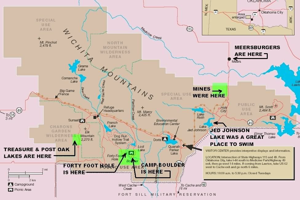
Here are a few images ... should answer your question, jbrown (Camp Boulder aka Boulder Camp once had several rustic rock buildings ... this is not the best map I've seen but what I could find quickly ... also see Official Site of the Wichita Mountains Wildlife Refuge
Area Map (from http://library.fws.gov/refuges/wichita.pdf )
Same map with a few annotations by me ...
Treasure Lake -- it's really lots prettier than this
Most, if not all, of these lakes were made during the Great Depression by CCC Boys ... I think that my uncle who died in 1941 (who I never met, being born in 1943) was one of them. See Civilian Conservation Corps (CCC) for more about the CCC.
Participating Member
Sunset used to be a campground as well, it's only a picnic area now. Park there. Hike to Treasure Lake via the Boulder Field! Downside, you have to go back up through the boulder field to get back to the car.
I believe you can get a permit for the "Special Use" areas. Or at least ya used-ta-could.
Andrew Stewart
Don't tell anybody...but Treasure Lake is a great swimming hole.
Doug: Thanks for posting. I have explored everyone of those places you mentioned except the mining area. I believe that is across the highway from the Parallel Forest? Just south of Camp Boulder is the Narrows...another cool place to both play in the water and climb a mountain in close proximity.
Man...I haven't been since August. Reading this thread makes me want to go.
VIP Member
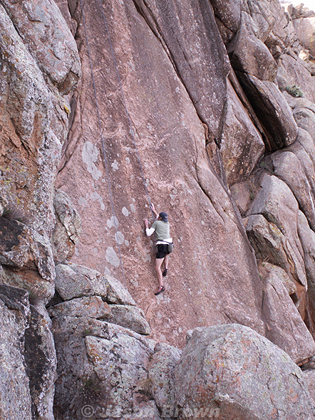
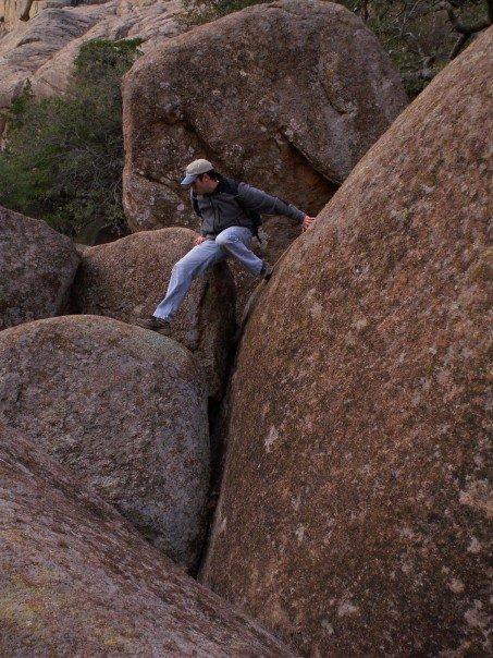
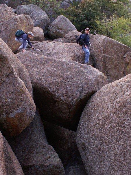
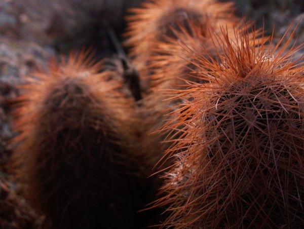
Some of my pics from the Wichitas.
climbing in the Narrows
inside Meers Restaurant
Lost Lake
Medicine Park
Boulder Valley (near Elk Mountain and Treasure Lake
cacti near Elk Mountain in Charon's Garden Wilderness
more here.
Andrew Stewart
Good stuff man. Good stuff.
Participating Member
Yep, I'm gonna have to go back soon. I used to go 2 or 3 times a month when I was younger.
VIP Member
Thanks Cuatro!
VIP Member
I don't know the name, Parallel Forest. And it's been so long ago that I can't be sure about the mountain we climbed to get to the mine area ... all I recall, generally, is that, on the road going north of the Holy City, we went under the fence and up a mountain before coming to the north boundary of the refuge, on the west side of the road.
I've used Yahoo Maps to assemble (copy, paste and reassemble) a rather large Wichita Mountains area map for my personal use and some of you might find it useful, also.
Link to large version (3761 x 1721 px): http://www.dougloudenback.com/misc/w...e_yahoomap.jpg
To usefully print the large version, it would be better to copy and then divide the image into segments so that road numbers, etc., would show up better.
Here's a much smaller and not really usable version of the same map which shows the area covered ... I intentionally went beyond the borders of the refuge to show various access roads, etc.
Very much enjoyed your pics, JBrown! Were you the fool climbing the big rock (1st pic) ???(just kidding!)
Participating Member
Yes, thanks for the visuals Jbrown! I need to visit again one of these days myself!
VIP Member
Your welcome.
Doug, that's not me climbing (that time
VIP Member
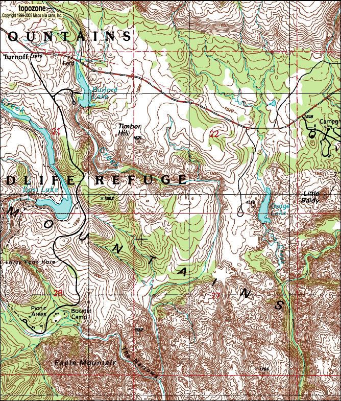
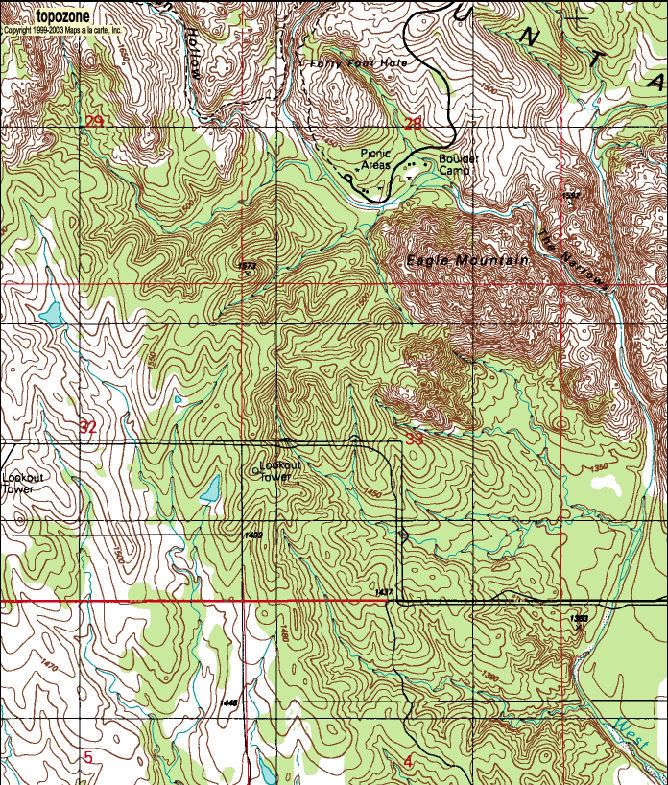
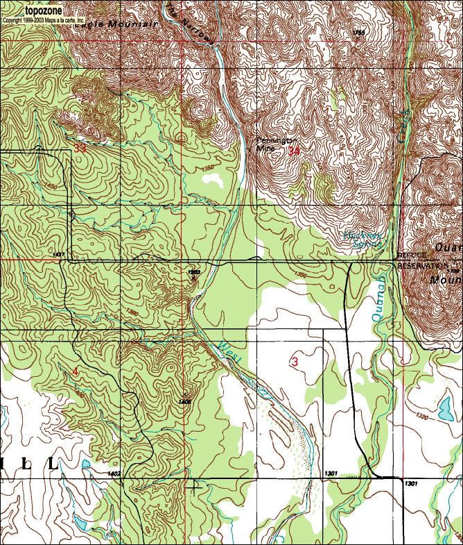
New to me but not maybe to youze guys, I've run across a great place for topographical maps generally and the Wichitas in particular: Topozone ...
TopoZone - Wichita Mountains National Wildlife Refuge Headquarters, USGS Quanah Mountain (OK) Topo Map
Though it's a bit tedious, you can meander through the sections presented, select "Print", but don't, and then do a "Print Preview" and there do screen caputures and paste the captured elements into your graphics program where you can crop the image and make it just right!
I've done several so far but haven't uploaded them all to my photobucket account (where I intend to stick 'em all when completely finished).
Here's couple of examples, though ...
Camp Boulder Area
Another View
Eagle Mountain, Just South of Camp Boulder
Another View
I suppose that it shouldn't be hard to reassemble them into one humongeous map, or some regional maps, when all is done with the segments.
I'm getting excited about getting down there again! Take my son & grandson and freeze, probably!
VIP Member
I posted a post a few minutes ago but I guess it didn't "stick." So I'll give it another go.
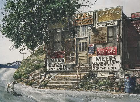
I've started my Wichitas post ... Doug Dawgz Blog: The Wichitas ... but there's a lot left to do. Particularly, I need some images ... what I've got there right now is Greg Burn's fine drawing of the Meers station, given to me by my daughter a couple of Christmas' ago ... volunteered images are welcome!
Larger image: http://i8.photobucket.com/albums/a49..._gregburns.jpg
And I've got to do the history and more stuff, too. But the clickable topographic map is done. A single large map is available (5200 x 2750 px, 5.44 MB) but this map is broken up into 18 navagatible segments. The segments are in 2 sizes, 800 x 800 px, and 1000 x 1000 px.
Andrew Stewart
Doug: I have a topo I bought at the vistor's center that I can scan an upload. It has a little more information. Will do this morning.
VIP Member
Great! I've given one I bought several years ago to my son ... it may be the same map and it would be great to have a scan.
By now, I've added some "beef" to the article ... still need some current day pics, though. I'd certainly give credit to anyone who wants to volunteer some! Not sure when I'll get down to take some pics myself, but hopefully not too long into the future!
VIP Member
Feel free to use any of mine, Doug.
VIP Member
Great, jbrown! I'll send you a pm ...
Participating Member

I've loved the Wichita since I was a teenager and have made at least one pilgrimage there each year since (30+).
I would disagree with Mr. Loudenback that it is over-regulated though. I remember back when it was more open that many of the camping areas were really rough drunk, drugged out places most weekends--this was early '80s when bikers weren't just mid-life crisis suburbanites but real outlaws and many of them considered specific campgrounds their turf. I got run out of a few places after being made aware that I was not welcome to be anywhere near thier turf.
Much of the park had gotten so rough that it wasn't suitable camping for most adults and kids would be out of the question.
I remember one of the last times I camped by Elk Mountain, a really scary dude came by at night to try and get us to go "smoke angel dust and watch the bats come out" at some unspecified spot off the trail. He, of course, was also offering to sell us the drugs.
There were also yearly deaths caused by idiots diving/jumping/belly flopping into the numerous streams and pools not aware that unlike the rest of Oklahoma, the bottom isn't mud but jagged skull piercing granite.
You can still get to many of the cool spots by permit and Camp Doris is a nice spot I don't hesitate to take my kids to.
I was in my forties before I even knew about the Wichita Mountains. I just love it there. Took my late father to get a Meers burger one time and that was a memory making trip. I am so glad I took him since he'd never been there, either.
There are currently 1 users browsing this thread. (0 members and 1 guests)
 Posting Permissions

 Reply With Quote
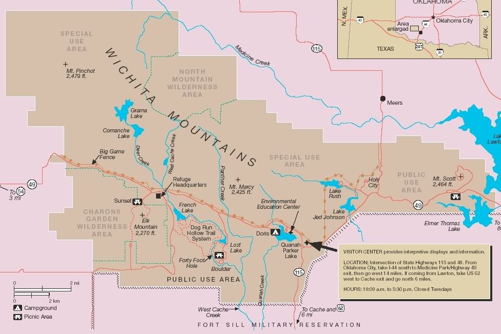


Bookmarks