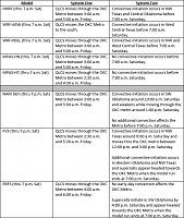
Sometimes with these complex multi-day convective setups, I like to make a table comparing the output of the different convection-allowing models. I am sharing that table here. Please note that this does not represent an endorsement of any of these solutions, it’s just meant to help make sense of the different potential outcomes.
As you can see, there is a high likelihood of OKC getting hit by a round of storms early tomorrow morning, with severe potential increasing as a majority of models show the QLCS remaining relatively robust even as it moves through the Metro shortly before the diurnal minimum.
Meanwhile, Saturday clearly has a lot of high-end potential, albeit with the final outcome still very much up in the air and likely dependent on the extent of early-day elevated convection and any corresponding cold pool, which could work to stabilize the atmosphere for an extended period of time and therefore put a ceiling on the extent and severity of any potential supercells which initiate around or shortly after the diurnal maximum.
Finally, this is just beyond the range of the convection-allowing models, but would also note that a lot of the traditional models are narrowing in on an extensive swath of thunderstorms that will likely train over the same areas for much of the overnight period on Saturday. Wherever this occurs, there will likely be an extended period of both severe weather and flash flooding. Currently, this seems most likely to occur just southeast of the OKC Metro, but we are certainly still within the margin of error for potential impacts.


 Reply With Quote


Bookmarks