Widgets Magazine
Page 5 of 6 FirstFirst 123456 LastLast
Results 101 to 125 of 131

Thread: December 2020 - General Weather Discussion

  1. #101

    Default Re: December 2020 - General Weather Discussion

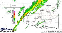
    Below images show the cold front sinking southeast and the line of storms that will eventually impact the area later this evening developing behind the front. Nothing has really changed in terms of expectations with this line since my post earlier today. Tomorrow, things are looking better for some snow to mix in before the precipitation ends. Minor accumulations will be possible on grassy surfaces, but there shouldn't be any travel impacts. Don't really feel like opening the Thursday/Friday can of worms yet lol, but it does appear that the chances of an impactful winter weather event are increasing, particularly for the western sections of the Metro. Still a lot of uncertainty, though. Wouldn't be surprised to see one final shot of light snow early Saturday before the upper level low finally moves out of the area. Saturday Afternoon through next Wednesday looks to be a dry period with near normal temperatures, before a more active pattern returns towards the end of next week.

    Click image for larger version. 

Name:	current.TAIR.grad.jpg 
Views:	44 
Size:	27.3 KB 
ID:	16638

    Click image for larger version. 

Name:	Oklahoma.MosaicBREF.jpg 
Views:	34 
Size:	29.5 KB 
ID:	16639

  2. #102

    Default Re: December 2020 - General Weather Discussion

    This storm’s evolution has continued to slow since earlier forecasts. Here in C OK we are just now about to see the coldfront after 10pm. This will bring rain and some rumbles of thunder.

    Most models have gone more in favor of early morning into lunchtime snow. Especially in a narrow band somewhere along or just north of the i44 corridor. Then snow will end early afternoon and all things will go quiet.

    As for the track of the main low on Thursday, most models continue to trend the track westward. As a result the highest chances for winter precipitation are dividing the state somewhere along or just west of i35.

    Will post some graphics in the morning. But the general trend is potential blizzard in W OK, ice storm just E of that, and a mixed bag to cold rain east of that. Gradients will be very harsh with this storm.

  3. #103

    Default Re: December 2020 - General Weather Discussion

    I am a little confused after watching the news and reading this thread, which i find (this thread) to be very helpful btw.

    I guess i am trying to plan ahead for potential power outages. 13 days of no power in Oct/Nov was awful. The news channels do not seem to be hyping the ice and freezing rain potential up just yet, but obviously that could change in a moments notice. They do tend to add fuel to fire and hype to the hysteria.

  4. #104

    Default Re: December 2020 - General Weather Discussion

    Waiting for some more model data to come in, but currently the storm continues to slow down from original forecast, track further SE, and the upper level low ejection pattern is now expected to be more tightly wound.

    For example, the current snowband that is in the area SE of I-44, was actually forecast to be to the NW of I-44. This pattern may extrapolate across the entire forecast area and timeline.

  5. #105

    Default Re: December 2020 - General Weather Discussion

    ^ Thank you. Will continue to keep an eye out here.

  6. #106

    Default Re: December 2020 - General Weather Discussion

    Snow in Seminole (from a construction cam taken about 10:30AM):


  7. #107

    Default Re: December 2020 - General Weather Discussion

    Most models have slowed the storm down, which is altering the evolution of the low's precipitation, the track of the low, and the temperatures.

    I will focus on our short-range hi-def models first. HRRR, and NAM. Other broad model data will be in later this evening.


    Latest HRRR shows slower storm and tighter low evolution. Resulting in dramatic shift eastward of main body of precipitation and the cold air. This latest forecast would mean W and NW OK would need to have Winter Storm Watches shaved away and adding Winter Storm Warnings or Blizzard advisories for a large area from SW to C to N OK.

    Here is two snapshots of HRRR showing the storm forecast over main part of OK. The first one is data from this morning that I saved, the next one is data from this afternoon. The second image is showing the storm arriving 3 hours later than the first image.

    Data from Wed AM:


    Data from Wed PM:


    Next up we have the NAM. NAM has been consistently move the storm track west until this morning when it began shifting back east a bit. It has since reverted back to the westerly track, but condensed the low and slowed the storm down. Current advisory levels are consistent with NAM forecast. This would keep most of the I-35 corridor in a cold rain scenario (temperatures right around 32-33). this would also track the heaviest swath of winter precipitation across W OK where they would have solid icing followed up by a quick dumping of blowing wet snow.


  8. #108

    Default Re: December 2020 - General Weather Discussion

    this will be a crazy 48 hours to watch

  9. Default Re: December 2020 - General Weather Discussion

    Quote Originally Posted by BoulderSooner View Post
    this will be a crazy 48 hours to watch
    Yeah! At least it's all Friday and we're off. Sunday is supposed to be sunny so I won't have any work problems by Monday. This one I can just sit back and watch.

  10. #110

    Default Re: December 2020 - General Weather Discussion

    I was hoping we would dodge the ice / freezing rain bullet and just deal with snow this time around. From the looks of things...i really have no idea.

  11. #111

    Default Re: December 2020 - General Weather Discussion

    seems like ice chances are down??

  12. #112

    Default Re: December 2020 - General Weather Discussion

    The gradient between different precipitation types is going to be so tight, expecting this to be a nowcast situation to see where the heaviest swaths of snow and ice end up occurring.

  13. #113

    Default Re: December 2020 - General Weather Discussion

    Like SEMI said, exact location and amounts is basically impossible for this storm. Here are some models, I would cut all these ridiculous "snow" amounts down to about a third of what they say, given a lot of this will be rain, freezing rain, and sleet.


  14. #114

    Default Re: December 2020 - General Weather Discussion

    Temps at OKC holding right now at 30F. This is going to be extremely close when the precipitation gets here. I am out of town so my updates will be fewer. I would guess the initial type falling OKC to be rain then mixing in with freezing rain and sleet pretty quickly given the wet-bulb temperatures.

    Then a quick burst of heavy snow early AM.

    Radar nowcast is the only way to know who gets what and how much.

  15. #115

    Default Re: December 2020 - General Weather Discussion

    Safe travels, and thanks for your updates. Always appreciate your posts.

  16. #116

    Default Re: December 2020 - General Weather Discussion

    Agreed, thanks for the updates and safe travels.

  17. #117

    Default Re: December 2020 - General Weather Discussion

    OKC above freezing as rain has arrived. Expect quick turnover to freezing rain and some sleet with wet-bulb being about 30-31.

    Current track of storm puts heaviest precip across C OK.

    OKC has been upgraded to Winter Storm Warning.


  18. #118

    Default Re: December 2020 - General Weather Discussion

    Precip is currently falling as rain at my apartment a few miles east of Downtown Yukon. Mesonet observations currently show 32-33 degree surface temperatures across the Metro. As Anonymous mentioned, expect the precipitation to change over to freezing rain fairly soon given sub-freezing wet bulb temperatures across the Metro. Temperatures will be marginal but winds will be fairly gusty so I'd still expect up to a quarter-inch of ice accretion on trees and power lines. Current short-range model trends show best potential for icing pretty much right along a Newcastle to OKC to Edmond line. To the west, more precipitation should fall as sleet and snow, and to the east, more precipitation should fall as rain. Still, I would expect pretty much everyone in the Metro to see every precipitation type between now and noon tomorrow, and road conditions should be hazardous across the entire area by late this evening.

  19. #119

    Default Re: December 2020 - General Weather Discussion

    A glaze of ice is now starting to accrete on elevated surfaces here. Hoping for a changeover to sleet or snow sooner rather than later.

  20. #120

    Default Re: December 2020 - General Weather Discussion

    Bad winter winter going on or slated to from the Mexican border at southwest Texas northeast to Canada.

  21. #121

    Default Re: December 2020 - General Weather Discussion

    Good! Mike Morgan at channel 4 thinks Oklahoma City will just barely escape from a major ice storm. Snow will be around 4".

  22. #122

    Default Re: December 2020 - General Weather Discussion

    Seeing some chatter that some drier air is getting ready to move through which will back off the heavy rain to something lighter.

    So, a bit of a break here soon.

  23. #123

    Default Re: December 2020 - General Weather Discussion

    Absolutely pouring snow out here on the west side now as the deformation axis has set up right over us. I just woke up recently and haven't seen any yet, but looks like there's been occasional lightning flashes over the last few hours as well. Pretty impressive event.

  24. #124

    Default Re: December 2020 - General Weather Discussion

    We got around 4 inches near Baptist hospital. Still have power thankfully but the trees are bearing the weight of ice and then snow on top of it, hopefully they can hold up and the melting starts soon. The snow is beautiful but i would take 80 degrees and sunny any day over this. Guess it could have been worse though

  25. Default Re: December 2020 - General Weather Discussion

    Quote Originally Posted by stratosphere View Post
    We got around 4 inches near Baptist hospital. Still have power thankfully but the trees are bearing the weight of ice and then snow on top of it, hopefully they can hold up and the melting starts soon. The snow is beautiful but i would take 80 degrees and sunny any day over this. Guess it could have been worse though
    I'm with ya on the 80 and sunny. My Miata is tired of collecting dust.

Thread Information

Users Browsing this Thread

There are currently 1 users browsing this thread. (0 members and 1 guests)

Similar Threads

  1. May 2020 - General Weather Discussion
    By Anonymous. in forum Weather & Geosciences
    Replies: 91
    Last Post: 05-30-2020, 07:16 AM
  2. General Weather Discussion - December 2019
    By Anonymous. in forum Weather & Geosciences
    Replies: 14
    Last Post: 01-02-2020, 10:55 PM
  3. General Weather Discussion - December 2018
    By Anonymous. in forum Weather & Geosciences
    Replies: 153
    Last Post: 01-01-2019, 10:44 AM
  4. General Weather Discussion - December 2016
    By Anonymous. in forum Weather & Geosciences
    Replies: 81
    Last Post: 12-30-2016, 07:00 AM
  5. General Weather Discussion - December 2014
    By venture in forum Weather & Geosciences
    Replies: 114
    Last Post: 12-29-2014, 11:41 AM

Bookmarks

Posting Permissions

  • You may not post new threads
  • You may not post replies
  • You may not post attachments
  • You may not edit your posts
  •  
Single Sign On provided by vBSSO