


Emily Sutton with updated forecast shows western part of Oklahoma City metro getting .5 to 1 inch of ice, which would be considered catastrophic.

Emily Sutton with updated forecast shows western part of Oklahoma City metro getting .5 to 1 inch of ice, which would be considered catastrophic.
 Participating Member


Considering the time of the year with foilage still intact. Anything at .25” will cause extreme damage to trees and consequently powerlines.
If the OKC metro ends up with anything close to an inch, this will likely be the most costly ice storm in state history.
Participating Member
That's a shame. A lot of people complain when a "Nothingburger" occurs because temps come in 1 or 2 degrees above from forecast well now were seeing the opposite of that.
Owner / Administrator

Freezing rain this early in the year is particularly bad because the trees still have their leaves.
I remember about 4 years ago we had a bad freezing rain storm before Thanksgiving and you couldn't even drive through Heritage Hills or Mesta Park because there were so many downed limbs. The city had to set special cleanup days just to pick up the debris all over town.
Participating Member
Branches are snapping over here and power is already out
Participating Member
Winter Weather Advisory expanded an additional row of counties to the SE, now including Tulsa. At this time, Ice Storm Warning counties remain unchanged.
There is still a solid stream of sleet and freezing rain training along I-44. Short range models show a break in the precipitation heading into tonight, so hopefully that happens.
Driving around south OKC, tree branches are covered with ice and sagging *everywhere*, notably in the areas near and around Earlywine Park (SW 119th and May). My power has glitched several times, but remains on. Power just a couple miles east is out. My weather station says its 33 degrees, but man, we lose that extra degree or two, and this going to be an unqualified mess. The potential for extensive tree damage around town is enormous.
So Wednesday's okc forecast is high of 44 with rain. So any ice on trees should mostly melt by Wednesday evening.
Participating Member
Yes, forecast is for OKC to go above freezing by Tuesday night and begin the melting process. Rain will become heavier as the low is ejected across the region. Heavy rainfall should actually help to warm the surface temperatures.
The problem is the forecasted light drizzle and waves of freezing rain late Monday night into Tuesday morning. Especially across areas where ice has accumulated on elevated surfaces. The ice will act like icecubes do inside a cooler or freezer and will actually cool the air at the surface.
One interesting aspect is the colder air coming in aloft may help to mix more sleet or snow into the precipitation hours which will help the tree scenario, but worsen the travel.
Basically just like 90% of winterstorms for OKC, every fahrenheit matters.
Participating Member
Round 1 seems to be exiting the area.
Owner / Administrator
Lots of downed tree limbs everywhere and even more trees hanging low in roadways.
Gold Member
We've been without power for 3-4 hrs in Crown Heights, and it's only getting worse. OG&E and Asplundh have their work cut out for them.Originally Posted by Pete

Gold Member
No power outages here in Norman yet but I am sure we will get there tonight and tomorrow. Stay warm and safe everyone.
Participating Member
I enjoy a good snowstorm but I hate the ice. So destructive and so dangerous.
In Stillwater, the freezing rain let up fairly soon after temp went below freezing. So ice didn't accumulate too much on the trees. Wave 2 forecast is for .3" ice in Stillwater. That much is worrisome. Stillwater hasn't had a bad ice storm since around 2003. It's amazing how the town dodged at least two of them since then when Perry and my boss's rural home was encased from one of them and Cushing-Perkins got the other one. Rural co-worker didn't have power for over a week.
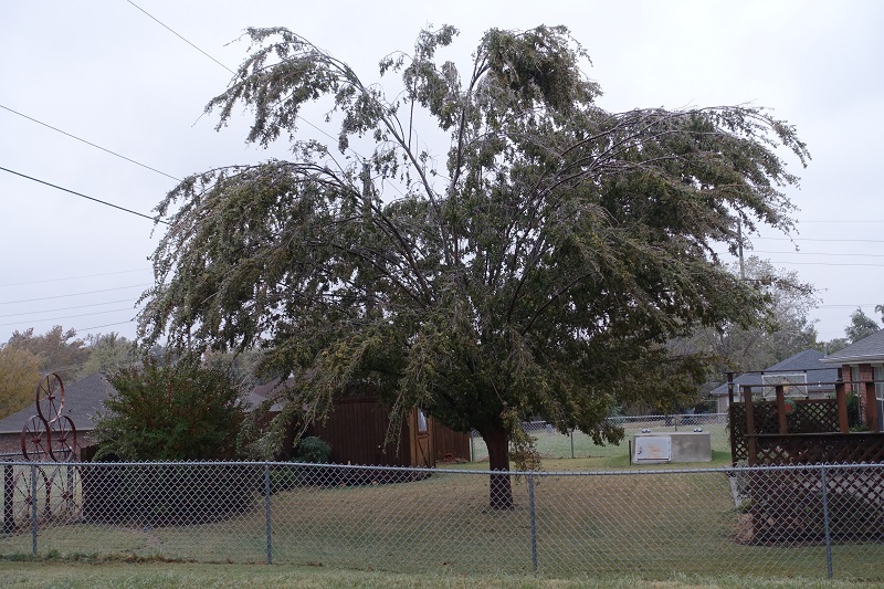
Neighbor's tree doesn't look too bad after wave 1.
Gold Member
I have a tree that I've been thinking about removing for a couple years but just couldn't bring myself to cut down a perfectly healthy tree. From the looks of how it's drooping it might make my decision much easier.
Participating Member
I went out earlier and was beating on my trees with a big stick. Knocked off a lot of the ice. I probably looked like a crazy man lol!
I hate ice though. It’s so destructive to even the heartiest of trees.
Participating Member
I'm really worried about Tuesday Morning with this ice storm. This morning (monday) we were around 30-31 and started with very warm ground temps. Now we have some ice on the ground temps are running 28-30. Tuesday morning might be 100 times worse than this morning. The roads were ok and still are for the most part but tomorrow might be really ugly. Rain with temps around 29 and a cold ground is way different than rain at 31 with a warm ground.
Participating Member
00Z HRRR coming in with a forecast of over 20 hours of freezing rain, drizzle, and sleet across a localized area from OKC and down to the SW towards Lawton.
Canadian, Caddo, and Grady counties look like it could be awful. This bleeds into Oklahoma county as well. Every degree matters.

Participating Member
Thanksgiving 2015. I had a pile of branches in my front yard 5 feet high by 15 feet long for over a month Before the city was able to pick em up.
Participating Member
The 2015 Thanksgiving ice storm made that decision for us on a couple of trees in our front yard, and now we have a yard again.
Banned
I am off tomorrow thanks to the storm so it is nice to have a day off
Participating Member
I'm at home today and I have already heard several good pops from the trees outside. This is so sad....
Participating Member
What I mentioned yesterday is ocurring with rainfall happening so rapidly that it is actually warming the surface layer. This should bring the region above freezing quicker and thus stop the accumulations.
Participating Member
This is wonderful news.
Hope it warms faster than the afternoon.
There are currently 1 users browsing this thread. (0 members and 1 guests)
 Posting Permissions

 Reply With Quote
Bookmarks