

The connection of the River Trail to the Katy Trail continues:


 Owner / Administrator


The connection of the River Trail to the Katy Trail continues:
Participating Member
Money well spent
Participating Member
Since the trails were mentioned in the OKANA thread it reminded me to ask the following question about the new signage. I road my bike from Wheeler to Crystal Lake Saturday and noticed that the signs are merely mile markers for the trail that I was on. There is still no directional markers indicating that a new trail is coming up or that it is this far from this point to this point etc. The only way I knew that the trails connect is because I looked at the website and paid a lot of attention when the MAPs trails were being proposed. That is not very helpful if you are on the trail and don't know about the system. Just think of all of the visitors to our city that stay on the trails at Meridian. A few weeks ago I was on the North side of the River Trail and noticed there is still not a sign at May that indicates that the Will Rogers Trail links there if you turn north. There is a sign at the parking lot that indicates that you are on the Will Rogers Trail but that is not visible from the River Trail. The signs are lovely and should last a while but even a map that shows the entire system would be helpful. Please tell me that there is more to come.
I _think_ there's more to come with the current effort, but I also I just checked my MAPS4 handbook and there is definitely mention of wayfinding and signage

Participating Member
I hope there is input from people who use the trails about the wayfinding. Thanks for the information shawnw
All maps meetings are open to the public, though, at least in my subcommittee meetings, members of the public rarely appear.
Participating Member
I must admit, I don't know when the meetings are. If I am available, I would love to come.
The connectivity subcommittee meeting (covers bike/ped/transit, which includes trails) is the first wednesday of the month at 1:30 at the embark conference room in the arts dist parking garage. Though we haven't talked about trails yet. Recommend keeping an eye on the agenda and showing up when topics to your liking are planned to be discussed.
Participating Member
I would if I could but I have a standing meetings every Wednesday at that time. Bummer.
 Participating Member
And that is why nearly no one shows up. Most of the world has to be at work and can't take off an entire afternoon for this.Originally Posted by shawnw

I'm aware. I have to take off work once a month in order to be a citizen volunteer and be on the subcommittee...
Participating Member
The Deep Fork Creek trail extension at 4.2 miles funded by the Better Streets Initiative broke ground and should open by early 2023:
- https://www.velocityokc.com/blog/dev...ack=super_blogConstruction began this week for one of the 13 trails included in the Better Streets program.
Deep Fork Trail begins on Grand Boulevard where the Katy Trail ends, just south of I-44 and Grand Boulevard, a quarter mile south of the National Cowboy & Western Heritage Museum. The trail will continue west of the Deep Fork River over Western Avenue and under I-44, connecting to the Grand Boulevard Trail that currently ends on the ramp to westbound I-44.
The trail itself is going to be about 4.2 miles long.
“It is going to be the last segment of trail to complete an interloop around Oklahoma City that uses the Grand Boulevard Trail, Katy Trail, and the new connection of the Oklahoma City River trails that is being constructed right now,” Halff Associates Inc. Oklahoma Office Director of Planning and Landscaping Architecture Nate Clair said.
Once Deep Fork is complete, a loop will be made around the metro area.
The bids opened for it this week followed by construction expected to begin late this year or early 2023.
The bid includes a 12-foot multi-use concrete path with several pedestrian bridges that will cross the Deep Fork River, as well as additional trailhead access points with paved parking for trail access.
“It should take about a year for construction,” he said. "They are bidding it in multiple phases. How those come back will determine how much of the trail will be built.”
Clair said the idea for Deep Fork Trail began in 2018 and started as a segment of about three-quarters of a mile. It was part of the Transportation Alternatives Program with the Oklahoma Department of Transportation.
“What is really exciting about this corridor is its location. It really ties into the Adventure District. It passes by residential neighborhoods. It passes by multi-family housing,” Clair added.
“There is just opportunity, not only to be a recreational trail, but an active transportation corridor for a number of users.”
Platinum Member
I failed to ever post pictures of it, but a fair stretch of the Deep Fork trail spur that connects over to Zachary Taylor Park broke ground and was built earlier in the year. It's open to walk on starting from the park going north but after a bit stops where I assume there will be a bridge going north out over the Deep Fork.
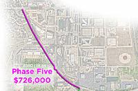
For reference here are the trail plans that were in a Community and Neighborhood Enhancement Advisory Board presentation from back in 2020, it's been two years but I assume the plans won't be particularly different. The completed stretch is in the Phase Four picture.
Participating Member
Thank you for the maps. It is very helpful for me to make sense of all of this. Do you have any idea how many miles the entire loop will be when everything is done? Living at Wheeler, I like to bike the trails when the weather is nice. My body is only good for about 15miles on a bike. I see my Strava friends who ride 50+ miles at a time on roads that look dangerous to me and hopefully they can have a nice long ride that doesn't involve risking their lives.
Also, is there a route from River Trails to Stanley Draper?
Interesting, on the phase four map the BNSF RR is shown to be Kansas-Missouri. Hmmm.
Participating Member
Just wondering for those of us who hate riding a bicycle, and cannot walk far, can we ride or drive the trail in a road cart or other 2 wheel cart? It would be nice to be able to trailer down and ride it or for some who want to drive their horse.
Participating Member
With the increase in traffic in Edmond, its getting harder to ride the roads. I would like to have the option to ride or drive from my house as an alt. form of transportation. I used to when I lived just off downtown, ride downtown Edmond.
Platinum Member
A lot of minor but interesting trail system updates from today's City Council meeting:
https://youtu.be/JF0RA7EunM4?t=5509
Specifically: creating new connections from the Katy Trail to local neighborhoods at 10th and 23rd, and an update on the Air Depot Trail
Owner / Administrator
Press release:
***********
Construction underway on Deep Fork Greenway Trail
12/21/2022
Work began this month on a 4.3-mile Deep Fork Greenway Trail.
The trail will run between the Deep Fork River. It will connect the Katy Trail at NE Grand and I-44 to the North Grand Boulevard Trail at NW Grand and NW 63rd, completing a 24-mile trail system.
“Creating connections between trails is our priority right now,” said Oklahoma City Engineer Eric Wenger. “Once the trail is built, people will be able to safely ride their bikes or walk from northeast Oklahoma City to Lake Hefner, connecting people to jobs, parks and shopping.”
The $14 million multiuse trail is being funded through the Better Streets, Safer City program passed by residents in 2017 and the 2007 General Obligation Bond. It will be completed in three phases; two additional phases will be awarded at a later date. The trail is expected to open in spring 2024.
The ADA-compliant, multi-use trail is designed for two-way bicycle and pedestrian traffic.
The trails are part of the Oklahoma City trails system.
Participating Member
Noticed while driving on I-44 EB yesterday that some of the Deep Fork Trail looks to be uncomfortably close to the highway. Hoping that there are plans to put up good barriers in those stretches.
Update for the section at MLK/First Americans Way and the River: There was a crane over there yesterday and they were able to set a bridge that crosses over an inlet into the river. I think they have 1 more bridge to set over the western inlet/flood control. You can see this last section in Pete's picture above.
They are setting this bridge today!
Participating Member
With that bridge complete the only missing section for the city loop is from Grand and I-40 to Nichols Hills and theyre working on it already. very exciting stuff
Participating Member
Is there work underway for the “Canyon Park” area? It’s a little secluded in there so hard to see if it is. Mostly curious about the trail’s path under BNSF, through Lincoln, and over to Kelley, where work is underway nicely.
Participating Member
The trail system in the median of Grand Blvd, west of May, is getting a major revamp. It's being widened to accommodate more types of modes of exercise. I will still cycle in the street though, because the sidewalk is still not a straight shot. It's like City planning thinks they need to enforce cycling speeds at crossings, so they keep a slight jaunt at the street crossings...smh.
There are currently 1 users browsing this thread. (0 members and 1 guests)
 Posting Permissions

 Reply With Quote
Bookmarks