

Some impressive storms going up north of OKC....

Some impressive storms going up north of OKC....
 Banned

David Payne is in his wheelhouse. Running and gunning
Participating Member
Well this escalated quickly.
Participating Member

They’ve had withdrawals since spring seasonOriginally Posted by brian72

Participating Member
Payne issuing radar indicated tornado just north of Oaktree
Participating Member
I am out of town once again when weather is hitting OKC.
Looking at radar on mobile. It seems like large storm complex will continue to sag down across OKC metro. There is a boundary that is anchoring this development across the area and it could possibly create a flooding threat if storms continue to develop over the same area throughout the night.
Brief spinups are possible along the leading edge of this complex. Heavy rain and hail will be the main threat. Enjoy the drink!
Participating Member
I was staged at Waterloo and Broadway and there were several good size power flashes at that point at mile to a mile and half to my west, southwest. Wouldn’t have surprised me if there was a spin up among the wind that blew through at that time.
Participating Member
Looks like the supercell is collapsing and the air rushing out of the column is coming down to the surface. Damaging winds will likely sweep across majority of the area if they haven’t already.
 Participating Member
This storm is absolutely crazy. Unbelievable rain, wind, and lightning.
Participating Member
My goodness this storm will not stop! An hour long so far the noise is just amazing. Wind driven rain with scattered hail. Had it been bigger hail my windows would be gone. Sustained storming. Still raining hard at least 2 inches and still going. Luckily still have power but had 2 spikes lucky my stuff is on battery backups. This is NW OKC
Participating Member
What a lightning show! Really fun to watch. The wind show, not so much. The tree in my front yard is down. It it older than 12 years. NW OKC
Participating Member
I'm on the 11th floor of 50 Penn. It's calmed down a bit now, but 30 minutes ago, I felt like I was on a boat, the building was swaying so hard.
Participating Member
Midwest City is getting hammered right now, based on radar.
Banned
What is going on with this storm!! OMG, the lightning here in Newcastle is crazy!!
Participating Member
Edit 2: 37,706 at 10:44
Edit1: 10,226 at 10:24
7,000 OGE out of power and can’t start fixing since its still lightening
Participating Member
OG&E
@OGandE
Outage count now over 37,000. Crews will work as it's safe to do so (no lightning). Be safe and stay away f/downed power lines. To report an outage, sign in to your account or call 800-522-6870. With continuing storms and so much damage, estimates are not available at this time.
10:45 PM · Aug 26, 2019·Sprout Social
https://mobile.twitter.com/OGandE/st...95074373431296
Participating Member
ast Update: 08-26-2019 11:32:08 PM
Total Customers Affected
57,181
Total customers affected does not reflect areas with fewer than 50 customers affected.
Participating Member
Deer Creek cancelled school this morning due to power outages.
Participating Member
https://twitter.com/CalebCalifanoTV/...946061824?s=20
90k without power and okc schools closed as well
Owner / Administrator

Last night was perhaps the wildest storm I've ever seen.
Non-stop lightning, 50 MPH winds and torrential rain. I got about 5 inches in less than an hour.
Surprisingly, no hail.
Participating Member
I was out just north of Yukon at sunset watching the initial towers go up to the northwest, and it was crazy how quickly everything unfolded. The amount of cloud-to-ground lightning that occurred between 8:30 and 9:00 was remarkable.
Participating Member
I guess you weren't here for the derechos of the late 90's, I'm thinking 1997 or 1998. Derecho created 100 mph winds that went all the way across the state. They happened in late July or early August in two consecutive summers.
One I recall the most, started with thunderstorms near Ponca City and created high winds that blew campers into Lake Eufaula. I was caught in that with my family on a camping trip, and my daughters never wanted to go to the lake again.
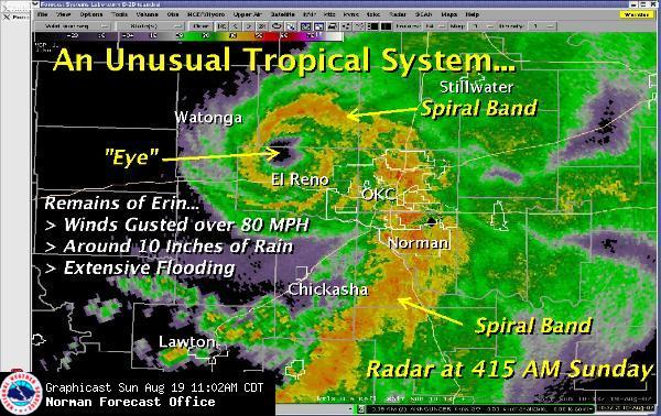
I've also seen tropical storms that reform over Oklahoma and create 80 mph winds, they become hurricanes over land.
There's no new weather events, if ya live long enough, you will see it all.
Participating Member
It was Tropical Storm Erin in 2007
Oklahoma
Caddo County, OK, August 20, 2007 -- This nursing home was damaged by high winds from Tropical Storm Erin.
After its unexpected redevelopment over Oklahoma, widespread damage was also reported there. Several communities in central Oklahoma were flooded due to the heavy rainfall. Watonga, Kingfisher and Geary were the hardest-hit communities, where many houses and buildings were inundated. The weather forced the cancellation of the Hydro Fair as the carnival rides were not safe in heavy rain and high wind. Winds in Watonga gusted as high as 82 mph (131 km/h), which damaged numerous trees and power lines and heavily damaged mobile homes. The entire community lost power, as did about 15,000 customers in total in the Oklahoma City metropolitan area. A section of Interstate 40 was also closed for a while.[43]
One person drowned in a cellar in Fort Cobb, and another drowned in Kingfisher.[44] Another storm-related death took place in Seminole.[45] Three others were found dead after a weather-related automobile accident also near Carnegie.[46] Another automobile accident fatality took place in Okmulgee County but it is unclear if the event was storm-related.[47] Damage amounted to over $2 million (2007 USD).[48][49]
Really wish I would have done a time lapse to the NW last night - the pic I posted at 8 was the beginning of some very impressive stuff.
Participating Member
I was at our shop by Memorial & Santa Fe till a little after 10 last night. I've lived in Oklahoma all my life and I have to say that had to be the loudest storm I've heard . Our shop was rockin.
There are currently 1 users browsing this thread. (0 members and 1 guests)
 Posting Permissions

 Reply With Quote
Bookmarks