

Anything big on the severe front in the near future? It seems like we've gone from a late winter to a more summer-like pattern very quickly.

 Participating Member


Anything big on the severe front in the near future? It seems like we've gone from a late winter to a more summer-like pattern very quickly.
Participating Member
I know it is only May 12th at the moment, so I can still eat these words.
This has been one of the worst springs I can remember as far as rain accumulations and nice weather. It was so cold so late this year, and now we're burning up like it's late June. Oh, and the WIND!!! I can't recall a windier spring than we're having this year. Unless things improve, this could be a brutal summer.
Banned
I don't see anything on the forecasts for severe weather going into two weeks. I started checking some other forums and it seems as though no chatter long term anything severe there either. I totally hope we are past that bridge for all that. Looks like only a 40 percent chance of rain midweek. I hope nothing comes of that either but Iess than 50 percent is a good thing.
Participating Member
Hazardous Weather Outlook
Hazardous Weather Outlook...UPDATED
National Weather Service Norman OK
1150 AM CDT Sat May 12 2018
OKZ004>048-050>052-TXZ083>090-131700-
Harper-Woods-Alfalfa-Grant-Kay-Ellis-Woodward-Major-Garfield-
Noble-Roger Mills-Dewey-Custer-Blaine-Kingfisher-Logan-Payne-
Beckham-Wa****a-Caddo-Canadian-Oklahoma-Lincoln-Grady-McClain-
Cleveland-Pottawatomie-Seminole-Hughes-Harmon-Greer-Kiowa-Jackson-
Tillman-Comanche-Stephens-Garvin-Murray-Pontotoc-Coal-Cotton-
Jefferson-Carter-Johnston-Atoka-Love-Marshall-Bryan-Hardeman-
Foard-Wilbarger-Wichita-Knox-Baylor-Archer-Clay-
1150 AM CDT Sat May 12 2018
This hazardous weather outlook is for portions of northern...
western...central...and southern Oklahoma...and western
north Texas.
.DAY ONE...Through Tonight...
.Thunderstorms...
A few strong to perhaps severe thunderstorms may occur between
5 pm and 10 pm today across parts of far western Oklahoma, west
of a Woodward to Hollis line. If storms occur, damaging winds up
to 70 mph would be the main hazard in or near storms.
.DAYS TWO THROUGH SEVEN...Sunday through Friday...
.Thunderstorms...
A few strong to severe thunderstorms with large hail and damaging
winds are possible during the afternoon and evening hours Sunday
and Monday across parts of western and northern Oklahoma as well
as far western north Texas.
Thunderstorm chances are expected to increase across all of
Oklahoma and north Texas Tuesday through Thursday. Some storms
Tuesday through Thursday may be strong to severe with damaging
winds as the main hazard.
.Heavy Rainfall and Flash Flooding...
Locally heavy rainfall of 1 to 2 inches in a short period of time
from slow moving thunderstorms may cause flash flooding in a few
locations across Oklahoma and north Texas Sunday through Thursday.
Get graphics and more details at weather.gov/norman...and follow
our weather forecast office on Twitter and Facebook.
 Participating Member
We've gone from March weather to June weather in about 2-3 weeks, with few signs of turning back. Absolutely brutal, and a very ominous sign for this summer. Even though rainfall has picked up in OKC recently, a good portion of Western OK is still in a severe or exceptional drought.Originally Posted by C_M_25

Participating Member
We should see storms develop across the OK/TX border in western parts of the state today around 5-7pm. Additional clusters/a line of storms will develop across NW OK. Models are pushing these storms off to the east into the night. The movement will likely be random, but generally off to the east. Clusters will form and die out while riding along outflow boundaries. So not everyone is guaranteed rain. Biggest severe threat will be winds with small gust fronts along leading edges and collapsing storm columns rushing air to the surface.
SPC has outlined the risks as Slight. Don't expect any organized severe weather except for the wind threats mentioned above.
Snapshot of sometime after midnight, showing random clusters around the state:

Participating Member
Storms rapidly developing now to the west and north. These will slowly begin filling in across NW OK and ride down on outflow boundaries toward C OK into the night time hours.
Participating Member
Storms developing off of remnant outflow boundaries from last night. Some of these look like they will cluster to the west of C OK and moving into OKC area in the next few hours.
Storms will redevelop again overnight across the area, again randomly and not organized.
Participating Member
Small boundary present on visible satellite that could be a focal point for a few storms this afternoon.

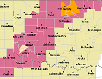
SEVERE THUNDERSTORM WATCH
Areas Affected:
Alfalfa - Beckham - Blaine - Caddo - Canadian - Comanche - Cotton - Craig - Custer - Dewey - Garfield - Grady - Grant - Greer - Harmon - Jackson - Kay - Kingfisher - Kiowa - Logan - Major - Noble - Nowata - Osage - Ottawa - Pawnee - Payne - Tillman - Washington - Wa****a
Effective: Sat, 5/19 2:30pm Updated: Sat, 5/19 2:34pm Urgency: Expected
Expires: Sat, 5/19 10:00pm Severity: Severe Certainty: Likely
Details:
SEVERE THUNDERSTORM WATCH 108 IS IN EFFECT UNTIL 1000 PM CDT
FOR THE FOLLOWING LOCATIONS
OK
OKLAHOMA COUNTIES INCLUDED ARE
ALFALFA BECKHAM BLAINE
CADDO CANADIAN COMANCHE
COTTON CRAIG CUSTER
DEWEY GARFIELD GRADY
GRANT GREER HARMON
JACKSON KAY KINGFISHER
KIOWA LOGAN MAJOR
NOBLE NOWATA OSAGE
OTTAWA PAWNEE PAYNE
TILLMAN WASHINGTON WASH ITA
Area covered:
VIP Member
^I'm guessing the forum blanked out the "bad" part of one of the towns?
I went around the auto censor by writing WA****A with a space in the word, so it would look less ridiculous. I failed to notice Wa****a, though. They're counties, not towns.
Participating Member
Something I find funny about language filters is situations like this where they tend to highlight 'hidden' 'bad' words. Perhapps the funniest example of nanny software run amok is when the word 'breast' is considered 'bad'. The maker of the software/filter tends to backpedal pretty quickly when it is pointed out to them that users uninstalled because they were unable to search for information on 'breast cancer'.
Thanks to overeager 'swear' filters I've even learned a few. Did you know 'bunda' is Portuguese for butt? I learned this playing a farming game with some friends, and we figured out that when setting up trades, we couldn't tell each other we had an aBUNDAnce of a certain item.
Back on topic though, I'm surprised by these storms lately, and the ones forecast for the next couple weeks. I was assured ...TWICE... there wasn't even so much as rain in the forecast until June, and yet I was woken up by thunder last night. Go figure.
I think it was the long-range *severe* outlook that was not showing much on tap. When you get a hot, humid wave like we've had, it doesn't take much to kick up an angry storm, but that's a far cry from the big stuff we normally worry about in May...
Participating Member
Decent rainfall for most of the state over the past weekend. This week will start off really nice (Monday) and end up feeling like summer heading into the weekend.
There is slight rain/storm chances Tues-Thurs, nut nothing organized and it will be random. Eyes turn toward the tropics this weekend which could have an effect on our weather. Otherwise the next shot @ something looking organized severe-weather-wise looks to be around the 30th.
Participating Member
Tropical development is looking likely now for this weekend in the GOM. Depending on the track and strength over the next few days will determine if OK gets any moisture from very far reaching bands. Again, anything that develops will be random and unorganized.
Looking ahead, full-fledged summer is on the doorstep. GFS showing 100F+ days this weekend in western OK and spreading eastward heading into June.
Banned
Does full fledged summer mean that severe weather season is finally over? It can’t be over soon enough in my eyes.
Participating Member
Thanks to the location, severe weather season is basically never over in Oklahoma. Full fledged summer means hotter than the deepest depths of Hades, but most certainly does not rule out the possibility of a storm, with June of 1995 having had 28 of them.
https://www.weather.gov/oun/tornadod...-monthlyannual
As you can see, while there are plenty of examples where you can pick a very specific month and year combo that didn't see a tornado (this year made the news for how long it took, actually), there is not a single month on the calendar that hasn't seen one.
TL;DR: If you're praying for storm season to end, you're in the wrong state. It's not going to.
Participating Member
We are in a statistical downward slope now though. Given enough time and data points you can find outliers in every month. As it stands right now, this season will end up one of slowest on record. Had a weird blocking pattern all season long.
Banned
It's going to get Hot and Dry for remainder of the Year. Hope I'm Wrong. You have to get the rain when you can because it's always easier to recover from a flood than a Drought.
Participating Member
A cluster or line of severe storms is looking more likely Friday evening across OK. Likely development to be somewhere near the OK/KS border and storms will ride south and east along their outflow boundaries. Damaging wind would be main threat with these. More random scattered storm chances over the weekend really anywhere in the state.
Meanwhile highs near 100 still on tap for large majority of the state heading into June.
Participating Member
100+ in June?? This is going to be a bad summer! The lakes are mostly at normal pool, which is fine now, but if we have an unusually hot summer, these lakes will get drawn down pretty quick.
Participating Member
It may even hit 100+ before May is over (Thursday). All-time May record is 104F, and we've only ever hit 100F in May 3 times. Both the Euro and the GFS are showing some outrageous (even seemingly implausible) temperatures middle-late next week. These will likely come closer to climatology as they get closer and the forecast gets more accurate/regresses toward the mean (I'd certainly hope so!), but it seems we're already sliding into a very hot pattern very early in the summer season... no bueno.
GFS
Wed: 96-97F
Thurs: 106-107F
Friday: 97-98F
Euro
Wed: 100-102F
Thurs: 102-104F
Fri: 107-110F (!?)
Participating Member
Thursday May 31:

Banned
Does this mean that a summer like pattern is settling in? A buddy told me that in June you don't have to worry about storms anymore and even though this is Oklahoma, if this weather settling in means a lot less/no severe then I will take sunny boring days and weather patterns over the worry of any severe weather.
There are currently 1 users browsing this thread. (0 members and 1 guests)
 Posting Permissions

 Reply With Quote
Bookmarks