Widgets Magazine
Page 1 of 3 123 LastLast
Results 1 to 25 of 62

Thread: General Weather Discussion - October & November 2017

  1. #1

    Default General Weather Discussion - October & November 2017

    Just realized I have been posting in last months threads. Going to copy my last two posts from today here:

    We will see storms develop this afternoon and evening across NW OK and down across NC TX. Storms will develop and track out of TX into S and SW OK and ride up over C OK during the overnight hours. Wednesday morning commute will likely be a wet one.

    Temperatures will be pretty static for the next week with highs in the low 80s and lows in the mid 60s.


    Storms are beginning to develop as said above.

    Short-range models are suggesting a concentrated area of heavy rain (4"+) somewhere over C OK. There is growing concern of local flash flooding by early morning wherever the development training occurs.

  2. #2

    Default Re: General Weather Discussion - October & November 2017

    FLOOD WATCH FOR METRO

    Areas Affected:
    Caddo - Canadian - Carter - Cleveland - Comanche - Cotton - Garvin - Grady - Johnston - Kingfisher - Lincoln - Logan - McClain - Murray - Oklahoma - Payne - Pontotoc - Pottawatomie - Seminole - Stephens

    Effective: Wed, 10/4 1:45am Updated: Wed, 10/4 3:45am Urgency: Future
    Expires: Wed, 10/4 7:00pm Severity: Moderate Certainty: Possible

    Details:

    ...FLOOD WATCH IN EFFECT THROUGH THIS EVENING...
    The National Weather Service in Norman has issued a
    * Flood Watch for flash flooding...flooding of creeks and
    rivers...and flooding of low lying areas for portions of central
    Oklahoma, east central Oklahoma, southeast Oklahoma, southern
    Oklahoma, and southwest Oklahoma, including the following areas,
    in central Oklahoma, Canadian, Cleveland, Grady, Kingfisher,
    Lincoln, Logan, McClain, Oklahoma, Payne, and Pottawatomie. In
    east central Oklahoma, Pontotoc and Seminole. In southeast
    Oklahoma, Johnston. In southern Oklahoma, Carter, Garvin,
    Murray, and Stephens. In southwest Oklahoma, Caddo, Comanche,
    and Cotton.
    * Through 7 pm Wednesday
    * Heavy rainfall will occur with periods of showers and a few
    thunderstorms through Wednesday afternoon.
    * Rainfall totals of 2 to 3 inches are likely with higher amounts
    possible.
    Precautionary/preparedness actions...
    A Flood Watch means there is a potential for flooding based on
    current forecasts.
    You should monitor later forecasts and be alert for possible
    Flood Warnings. Those living in areas prone to flooding should be
    prepared to take action should flooding develop.

    COUNTIES AFFECTED:

  3. #3

    Default Re: General Weather Discussion - October & November 2017

    Looks like the latest models are showing darn near 4 inches of rain in spots of central OK from today's system. Gonna be a soaker.

  4. #4

    Default Re: General Weather Discussion - October & November 2017

    Looks like the heaviest rainfall totals will line up from about El Reno to just north of the Guthrie area.

  5. #5

    Default Re: General Weather Discussion - October & November 2017

    How does 2017 compare to 2007 and 2015 in terms of annual rainfall so far? I am curious if OKC will be looking at a record or near record wet year this year.

  6. #6

    Default Re: General Weather Discussion - October & November 2017

    Definitely not like 2007. 2007 was unforgettable for a lot of rain. Some locations in central Oklahoma went over 60" for year's total, which were all time records. But weather is like real estate -- location, location, location. So it depends. My own annual tally just went over 34". Average annual is 36.71". Unless the rain shuts down for the rest of the year, all of Oklahoma should be able to get its average annual rain amount this year. If the heavy rain stays persistent for the rest of the year, you could be looking at one of the rainiest years ever.

    Pawnee to the northeast of me just went over 6", so once again, it gets down to location, location, location. And proves how hard it is to forecast the weather accurately. Pawnee County isn't in the flood watch when initially issued.


  7. #7

    Default Re: General Weather Discussion - October & November 2017

    Quote Originally Posted by Bunty View Post
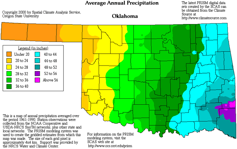
    Definitely not like 2007. 2007 was unforgettable for a lot of rain. Some locations went over 60" for year's total, which were all time records. But weather is like real estate -- location, location, location. So it depends. My own annual tally just went over 34". Average annual is 36.71". Unless the rain shuts down for the rest of the year, all of Oklahoma should be able to get its average annual rain amount this year. If the heavy rain stays persistent for the rest of the year, you could be looking at one of the rainiest years ever.
    Some areas in eastern OK are already approaching records. The all-time record is 76.61" in Broken Bow in 2009. For comparison a tropical rainforest typically averages over 80" annually.


    And average annual rainfall...would be interested to see 2000-2017 compared to this map of averages from 1961-1990:


  8. #8

    Default Re: General Weather Discussion - October & November 2017

    Spend 6 hours standing in the rain at the OKC PD shooting range, there was no point even trying to stay dry. It was soaked out there.

  9. #9

    Default Re: General Weather Discussion - October & November 2017

    As of 5:35 pm, Will Rogers World Airport in Oklahoma City has had a record of 2.56". Previous record on Oct. 4th was 2.22" in 1955.

    Rain in Pawnee is at 7.58". Rain there is about over.

  10. #10

    Default Re: General Weather Discussion - October & November 2017

    Chance of strong storms Friday evening. Storms will fire in a line from KS into the TX PH. These will push east as we head into the night and eventually weaken. Likely will not be severe by the time they reach C OK, but W OK could see gusty winds or small hail.

  11. #11

    Default Re: General Weather Discussion - October & November 2017

    Strong storm will be coming through the plains Monday evening. Rain chances will be mostly NE and E OK. But the entire state will feel a significant drop in temperatures as highs Tues and Wed will only be in the 60s. Lows will be down into the 40s until late week when we begin to moderate.

  12. #12

    Default Re: General Weather Discussion - October & November 2017

    SEVERE THUNDERSTORM WATCH out until 10 pm for the NE quarter of Oklahoma. Oklahoma County not included.

    Areas Affected:
    Adair - Cherokee - Craig - Creek - Delaware - Kay - Lincoln - Mayes - McIntosh - Muskogee - Noble - Nowata - Okfuskee - Okmulgee - Osage - Ottawa - Pawnee - Payne - Rogers - Tulsa - Wagoner - Washington

    Effective: Mon, 10/9 2:55pm Updated: Mon, 10/9 3:00pm Urgency: Expected
    Expires: Mon, 10/9 10:00pm Severity: Severe Certainty: Likely

    COUNTIES AFFECTED:

  13. #13

    Default Re: General Weather Discussion - October & November 2017

    Storms have started in southeast Kansas as of 3:30pm.

  14. #14

    Default Re: General Weather Discussion - October & November 2017

    Yes, boundary just came through OKC. Winds will shift from NW and cool air will filter down the rest of tonight and tomorrow. Open your windows and turn off the AC!

  15. #15

    Default Re: General Weather Discussion - October & November 2017

    Feels awesome!!

  16. #16

    Default Re: General Weather Discussion - October & November 2017

    Quote Originally Posted by SoonerDave View Post
    Feels awesome!!
    Sooooo agree!

    I love the cool fall weather... Sitting outside with my dogs loving life.

  17. #17

    Default Re: General Weather Discussion - October & November 2017

    I somehow don't think it's gonna be so comfy in the morning.

  18. #18

    Default Re: General Weather Discussion - October & November 2017

    Severe weather is likely Saturday evening. At this time, it looks like could see a line of storms come out of NW OK and swing through to the south and east. Damaging winds main culprit at this time.

  19. #19

    Default Re: General Weather Discussion - October & November 2017

    Storms should develop tomorrow afternoon late in NW OK and SW KS.

    This will spread south and east into the main body of OK as we head into the night. Storms should not be severe, but could get severe warned if winds appear to be strong with the line.


  20. #20

    Default Re: General Weather Discussion - October & November 2017

    Just like last week, we are building warmth ahead of the next storm. Which will once again be coming through Saturday evening. It will be basically identical to last weekend with storms coming out of the NW in a line, likely providing damaging winds.

  21. #21

    Default Re: General Weather Discussion - October & November 2017

    SPC has already upgraded Saturday to an 'enhanced' risk across OK. Models have hinted at potential for supercells to develop ahead of main squall-line. Any storms that do develop ahead of this line will have a window of opportunity for large hail and outside shot @ a small tornado. Nevertheless, the main threat still remains with damaging winds with the main line of storms.

  22. #22

    Default Re: General Weather Discussion - October & November 2017

    Models still hanging onto the idea of initial supercells. SPC hatched area over basically all of C OK for large hail and damaging winds with a weak chance of a tornado early. Hail and tornado threats will be with cells that develop ahead of the main line that will be coming out of W/NW OK. The line's focus will be damaging winds.


  23. #23

    Default Re: General Weather Discussion - October & November 2017

    Meanwhile, it doesn't look like a bad winter is coming with temps having a chance of being warmer than normal: http://www.noaa.gov/media-release/us...er-drier-south

  24. Default Re: General Weather Discussion - October & November 2017

    Quote Originally Posted by Bunty View Post
    Meanwhile, it doesn't look like a bad winter is coming with temps having a chance of being warmer than normal: http://www.noaa.gov/media-release/us...er-drier-south
    I guess that depends on how you look at bad..... We may be a powder keg if that drier forecast happens.

  25. #25

    Default Re: General Weather Discussion - October & November 2017

    Combined with a wet warm fall to get a lot of growth that can then dry up.

Thread Information

Users Browsing this Thread

There are currently 1 users browsing this thread. (0 members and 1 guests)

Similar Threads

  1. General Weather Discussion - August & September 2017
    By Anonymous. in forum Weather & Geosciences
    Replies: 76
    Last Post: 10-03-2017, 06:34 PM
  2. General Weather Discussion - June & July 2017
    By Anonymous. in forum Weather & Geosciences
    Replies: 95
    Last Post: 07-31-2017, 01:40 PM
  3. General Weather Discussion - September & October 2016
    By Anonymous. in forum Weather & Geosciences
    Replies: 77
    Last Post: 10-25-2016, 08:07 AM
  4. General Weather Discussion - November 2014
    By venture in forum Weather & Geosciences
    Replies: 122
    Last Post: 11-29-2014, 08:11 PM
  5. Oklahoma Weather Discussion - October/November 2012
    By venture in forum Weather & Geosciences
    Replies: 68
    Last Post: 12-02-2012, 04:04 PM

Bookmarks

Posting Permissions

  • You may not post new threads
  • You may not post replies
  • You may not post attachments
  • You may not edit your posts
  •  
Single Sign On provided by vBSSO