

Tornado watch is out for basically SW of the OKC area and down into NW TX.

 Participating Member


Tornado watch is out for basically SW of the OKC area and down into NW TX.
Participating Member
The mist and showers here in C OK have lowered temperatures significantly.
The main severe storm that was producing tornadoes earlier is headed right into C OK this evening, but the main threat will be wind and hail as the storm will likely begin to dissipate as it heads into the rain-cooled air.
Participating Member
Storm coming into OKC now. Severe warning on it, strong winds. Maybe some small hail. Nice rain.
Participating Member
Awkward setup today with the low due to track southeast across the state from western KS.
Depending on how much daytime heating can occur in these morning and early afternoon cloud-breaks will determine the severity of development. At this time the best shot is from around I-40 and north, and then I-35 and east. Storms will be capable of producing large hail and could have tornado potential with isolated cells that interact with weird boundaries scattered throughout the state.
These cells will be spinning around a tight, main low that sags south and east, predictability of development locations and cell paths will be nearly impossible. Everyone in C, N, and E OK should all stay alert for this afternoon and evening.
Participating Member
Watch has been issued:
NWS Storm Prediction Center Norman OK
1255 PM CDT Thu May 11 2017
The NWS Storm Prediction Center has issued a
* Severe Thunderstorm Watch for portions of
Northwest Arkansas
Southern Kansas
Southwest Missouri
North-central and eastern Oklahoma
* Effective this Thursday afternoon and evening from 1255 PM
until 900 PM CDT.
* Primary threats include...
Scattered large hail likely with isolated very large hail events
to 3 inches in diameter possible
Isolated damaging wind gusts to 70 mph possible
A tornado or two possible
SUMMARY...Severe thunderstorms are expected to develop and increase
this afternoon, initially across north-central and northeast OK
along and north-northeast of a surface low and residual outflow
boundary. These storms will spread into additional parts of eastern
OK, southern KS, southwest MO, and western AR through late afternoon
and early evening. Large hail should be the most common threat, but
locally damaging winds will also be possible along with some tornado
risk, mainly near the residual outflow boundary across parts of
north-central to northeast/east-central OK.
The severe thunderstorm watch area is approximately along and 60
statute miles north and south of a line from 15 miles west of Enid
OK to 30 miles east northeast of Fayetteville AR. For a complete
depiction of the watch see the associated watch outline update
(WOUS64 KWNS WOU8).
PRECAUTIONARY/PREPAREDNESS ACTIONS...
REMEMBER...A Severe Thunderstorm Watch means conditions are
favorable for severe thunderstorms in and close to the watch area.
Persons in these areas should be on the lookout for threatening
weather conditions and listen for later statements and possible
warnings. Severe thunderstorms can and occasionally do produce
tornadoes.
&&
AVIATION...A few severe thunderstorms with hail surface and aloft to
3 inches. Extreme turbulence and surface wind gusts to 60 knots. A
few cumulonimbi with maximum tops to 500. Mean storm motion vector
25025.
...Guyer
Severe thunderstorm watch until 9 pm. It does NOT include Oklahoma County:
Severe Thunderstorm Watch
Issued: May 11 at 12:55PM CDT
Expiring: May 11 at 9:00PM CDT Urgency: Expected
Status: Actual
Areas affected:Adair; Alfalfa; Cherokee; Craig; Creek; Delaware; Garfield; Grant; Haskell; Kay; Kingfisher; Latimer; Le Flore; Lincoln; Logan; Major; Mayes; McIntosh; Muskogee; Noble; Nowata; Okfuskee; Okmulgee; Osage; Ottawa; Pawnee; Payne; Pittsburg; Rogers; Sequoyah; Tulsa; Wagoner; Washington
Area Covered:

Participating Member
Area from Perkins to near Stillwater needs to stay alert. This large supercell is riding along the boundary and could ramp up very easily. Tornado potential is still a possibility with this cell.
As for the rest of C OK, OKC will be in the clear for the severe stuff, may get some wrap-around thunderstorm/rain showers later this evening as the low continues moving ESE.
Participating Member
Tornado warning in effect for that cell now. Stillwater needs to prepare for cover.
South of that, near Perkins and slightly south of Perkins, you will receive baseball+ size hail.
Participating Member
Tornado threat lowering for Stillwater. And now ramping up for town of Perkins and points east/northeast in toward Cushing.
Participating Member
Reports of rain wrapped tornado headed into Stillwater from the west. Reports are iffy, but take precautions.
Also the cell south of there in Perkins that I mentioned above is also tornado-warned now.
Tornado sirens have been sounding in Stillwater with moderate to heavy rain. Not much thunder and lightening. Fortunately, it looks on radar most of Stillwater will stay between the worst parts of two storms. Towns getting the brunt, like Perkins, Ripley, and Glencoe need to be concerned.
Participating Member
Tornado warnings have expired for now. Storms are beginning to become more linear.
Intense there for about an hour.
This was the view looking east from the 8100 block NW 119 (in OKC) about 3 PM today!

Platinum Member
Beautiful picture, Jim. I caught this one at Britton and I-235 right about that same time as the storm in the Stillwater area was under a tornado warning. It's not nearly as pretty as yours.Originally Posted by Jim Kyle


Participating Member
Looking at the 90 Day Rainfall totals this morning after yet another rain opportunity bypasses our land near the Arbuckles.
It's starting to look like we are going to have our own personal desert right at Woodford... 3" difference in rainfall around us... A 3" rain is about 4' of water elevation in my pond which is about 6' low right now compared to last year.
Participating Member
^^ I wouldn't start writing a book about the drought just yet.
A trend toward severe weather and flooding rainfall is ramping up beginning about the middle of next week.
Here is the GFS projected rainfall over the next two weeks:

Participating Member
LOL.... Yeah, we still have about a month and a half of rainy season... I'm not going to believe it until I see it though.... We've had several 3"+ predictions and that one little spot on the map keeps getting missed.... Fortunately I have a huge drainage basin that flows into my pond.... So I just need one good rain to actually move over us and I'll be at capacity.
Platinum Member
Insanely beautiful rainbow last night followed by the extra added bonus of a double rainbow:

Platinum Member
Sorry I can't figure out how to rotate the last two photos.
Participating Member
You just cock your head to the left.
Platinum Member
Works for me! It's funny, because in iPhoto they're all upright. Something happens when I attach them here.
Participating Member
I've had the same thing happen when posting pics straight from my iPhone.... Someone explained it on another thread but I don't remember the explanation... lol
Participating Member
Took these pictures while driving home on I-40 and I-44 last evening.

Participating Member
http://www.okctalk.com/showthread.ph...799#post966799
 Participating Member
Snip it from NWS Norman from this afternoons forecast discussion on next week.
An active weather pattern is expected to
begin early next week and continue through the entire week. Severe
thunderstorms are a growing concern for Tuesday, and potentially
later in the week as well.
There are currently 1 users browsing this thread. (0 members and 1 guests)
 Posting Permissions

 Reply With Quote
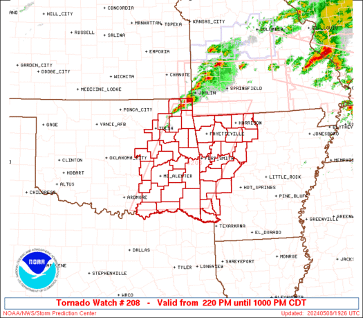

Bookmarks