

I remember for sure when he was on KFOR, even his first year on 9 he got way too excited. But since he's really calmed down, maybe he took some pointers from Gary.Originally Posted by NikonNurse


 Participating Member

I remember for sure when he was on KFOR, even his first year on 9 he got way too excited. But since he's really calmed down, maybe he took some pointers from Gary.
Participating Member
Yeah I agree, his first year with Gary he was very excitable and even for a bit after Gary retired but last year I thought he was phenomenal in keeping his cool and explaining how the risks are there but slim and they'll be watching it closely.
Now that said, when sh*t does start popping off he tends to go back to his roots and get very excited. But I'm kind of ok with someone being excitable when storms are bad, it keeps people engaged and watching.
Participating Member
As long as it doesn't seem like the boy who cried wolf, if there is a good chance of extreme danger, then the weatherperson should show a level of excitement, that transfers over through the tube and makes you feel that there is a sense of danger, but if they do it because of some drizzle or whatever then people won't react the way they should.
Participating Member
Saw a bunch of people on other forums doubtful on moisture return up into central OK, but I'm guessing SPC is a bit more confident if they upgraded us to a moderate.
Participating Member
Will we be using venture's chat today?
 Participating Member

I will be active later today. If someone can post the link to the chat that would be helpful. I am out of town, but will update later. Wasn't expecting the higher potential today.
Participating Member
Yep, looks like 60 degree dewpoints are already coming into southern Oklahoma.
Link to chat:
http://www.weatherspotlight.com/chat.html
Participating Member
Will this early line of storms suck some of the energy out of the atmosphere?
Participating Member
No. Full destablization is already back in C OK. Tornado watch is in place.
Money zone is Norman and south, but the northern edge will have some funky boundary plays. There is a possibility storms will be too crowded to become organized. But anything staying isolated will have a shot at major hail and tornado potential. Lack of warmer air at the surface could inhibit any tornado potential.
Participating Member
Action all south for now. Towers struggling west of OKC.
Participating Member
Darn! another missed shot at some rain. I know last week they were talking about the storm systems lining up all the way out into the pacific...well here in Midwest city we are 0 for 2 now.
Participating Member
Looks like most of the state is gonna get drenched this week. I hope so, I'd love a good soaking rain to start spring out right.
Participating Member
^ the entire state needs it.
Looks like it may be coming this Tuesday evening in the form of severe storms. Right now it looks like a pretty classic setup for severe storms developing in NW TX and W OK and then pushing east from there. More details will be known tomorrow.
Looks like S and S Central OK are presently in the higher-risk area for severe weather going into this afternoon. That frontal boundary runs almost parallel to the Red River from the SE Texas panhandle to the east and will move north through the day.
I get the impression that there is variability in the timing (isn't there always?) and that prospective region for severe weather could creep farther north near the metro. I would expect the "triple point" near that low, the dryline, and the front would remain a focus of attention as the system migrates north today.
I'll be interested in the next SPC update...we'd planned to go downtown this evening for a family birthday, but at this point I'm not sure if that's a wise idea....
One thing of interest I'll post here is the current "probabilistic" map for tornadoes, and right now that clearly focuses on the area just SW of OK in the SE TX panhandle, with a 10% risk area outlined in that area (this map was posted here about 6:45AM this morning):

Participating Member
Great chance for solid rainfall across much of the state, particularly C and N OK.
Moderate risk just added this morning across SW OK, 5% tornado area expanded to include a larger portion of C and S OK where there is some model indication of cells forming out ahead of the main cluster which would heighten rotation chances.
We should see a few small showers and storms pop up across WC to NW OK late morning into around lunchtime, but these will quickly push north and fizzle out. The main show comes tonight around nightfall when broken line(s) of storms develop across SW OK and NW TX and parade into C OK. Some models suggest additional clusters/lines developing behind the main wave. The severe threat will be with the initial line as potential exists for straight-line wind damage across C OK. Isolated tornado threat possible down in SW OK where cells will have a longer lifespan of being isolated. Per usual, any cells developing out ahead of the main cluster will have a bigger threat for hail and rotation.
Worth noting, GFS paints ugly picture across OK this Saturday. Still far out for changes, but SPC is already painting a 10% zone on the state for Day 5.
Anon, what's your best guess about when this really comes into OKC? Saw an NWS map that put OKC on the (roughly) eastern edge of a window from 8pm-11pm IIRC, which would tell me we're more likely on the latter part of that time frame...
Participating Member
I think OKC could see several waves of development. A lot will depend on the clearing that is taking place across the state.
If you made me guess, I would say 8pm is a good bet. But NAM does suggest potential for earlier development out front of a main line.
Good enough. Trying to decide if we want to bother getting out tonight for a family event in Bricktown
Participating Member
Warm air rushing north with dewpoints near 60F. On going storms in NW TX are starting to get rowdy.
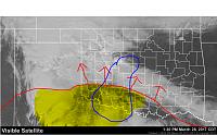
Area in yellow will be prime for development this evening and this area is expanding northward. The area I circled in blue is the region where short-range models indicate the scenario of training cells that are more isolated than the line that will be forming further to the west. These cells will bear a closer watch as we head into the evening hours.
Participating Member
MD is out:
Mesoscale Discussion 0355
NWS Storm Prediction Center Norman OK
0244 PM CDT Tue Mar 28 2017
Areas affected...Northwest Texas into southwest Oklahoma
Concerning...Severe potential...Tornado Watch likely
Valid 281944Z - 282215Z
Probability of Watch Issuance...95 percent
SUMMARY...Ongoing severe thunderstorms as well as new development
are expected to spread across much of northwestern Texas and into
southwestern Oklahoma through evening, with a threat of tornadoes,
wind and hail. A new tornado watch is likely.
DISCUSSION...A broken line of supercells currently extends from just
east of Lubbock toward Midland along a dryline. To the east into the
Abilene area, visible satellite shows deepening boundary layer
cumulus where heating is occurring. Just to the north, stable billow
clouds were noted which also corresponds to an area of
backed/easterly surface winds.
Models continue to suggest a large cluster of cells developing ahead
of the western line of storms by about 21Z. These cells would then
spread northeastward.
All modes of severe appear possible in this situation. Cellular
activity may become supercellular with a tornado threat as the
boundary layer shear will be increasing this evening. However,
magnitude of storm interaction is unknown at this time, which could
have a negative impact on tornado potential. Even so, a merging
cluster could still result in one or more severe bows containing
damaging wind and hail.
..Jewell/Guyer.. 03/28/2017
Participating Member
Is chat going to go? That is real helpful here at work.
Participating Member
Yep, chats up. Pretty quiet now until things get going though.
Link again:
http://www.weatherspotlight.com/chat.html
Participating Member
Virtually every cell is tornado-warned down in NW TX. The trend is for them to cluster up and become less favorable for tornados, but with sunset we could see a timeframe of favorable conditions which makes cells split again, or train in a line with appendages capable of producing spinups.
Keep an eye on south-central OK for cells to develop ahead of the main cluster. Anything developing in that area will have a solid shot at becoming strong storms.
Participating Member
Tons of redevelopment behind this initial cluster. This will be a fantastic soaking for a lot of OK.
Participating Member
Severe Thunderstorm Warning for basically all of OKC metro. Straight line wind gust is the main threat as the line is bowing out. After that it is a localized flash flooding threat.
Enjoy the drink tonight!!!
There are currently 1 users browsing this thread. (0 members and 1 guests)
 Posting Permissions

 Reply With Quote


Bookmarks