

Tornado warning for the area west of Okmulgee to Muskogee.

 David
David

Tornado warning for the area west of Okmulgee to Muskogee.
David
Main feeder band from Purcell to Seminole to Okemah to Okmulgee to Muskogee has areas with in that could cause a quick spin up. They'll be moving NW at about 15-25 mph.
David
Area west of Okemah, between Castle and Bearden has some weak rotation in there.
Participating Member

OKC will get how much rain out of this before it ends? 10 inches possible is what I heard this morning.
Participating Member
SC OK is already approaching 10 inches and still raining heavily down there.
Right now the low has stalled out directly over I-35 north of Dallas/Fort Worth. Currently, the intensity of the rain in and near OKC is not even close to that just to the south and east of the metro.
Participating Member
Seeing some reports on Twitter that the risk to south and east metro could be increasing as the storms positioned slight more NW.
Participating Member
FWIW...
https://twitter.com/ounwcm/status/611342249868197888
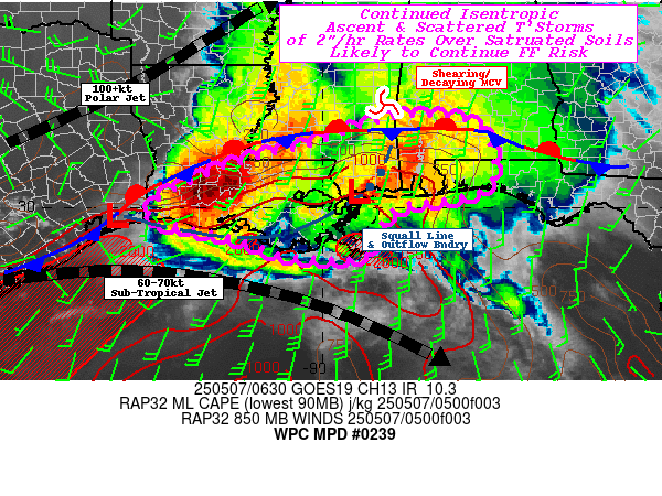
Here's the full WPC briefing:
MESOSCALE PRECIPITATION DISCUSSION 0239
NWS WEATHER PREDICTION CENTER COLLEGE PARK MD
907 PM EDT WED JUN 17 2015
AREAS AFFECTED...SRN OK...CENTRAL OK...ERN OK...NRN TX...WRN AR
CONCERNING...HEAVY RAINFALL...FLASH FLOODING LIKELY
VALID 180107Z - 180707Z
SUMMARY...A DANGEROUS FLASH FLOOD EVENT WAS UNFOLDING IN THE
ARBUCKLE MOUNTAINS OF SOUTHERN OK. EXCESSIVE RAINFALL WILL ALSO
FALL ON A BROAD PART OF OKLAHOMA AND ADJACENT NORTH TX AND WESTERN
AR TONIGHT.
DISCUSSION...OKLAHOMA MESONET OBSERVATIONS REVEALED INTENSE RAIN
RATES NEAR ARDMORE OK...AS EASTERLY FLOW AROUND THE CENTER OF T.D.
BILL WAS PRODUCING UPSLOPE FORCING INTO THE ARBUCKLE MOUNTAINS. AS
OF 0045Z RATES OF 5 INCHES IN 2 HOURS HAD BEEN MEASURED. TEH
CENTER OF BILL WAS LOCATED ABOUT 40 MILES SOUTH OF THIS AREA...AND
THE RAP MAINTAINS STOUT EASTERLY LOW LEVEL FLOW THROUGH AT LEAST
03Z. THE MESONET STATION AT NEWPORT HAD TOPPED 8 INCHES AND MAY
EXCEED 12 INCHES BEFORE THE EVENT THERE EASES.
A MORE GENERAL RAINFALL OF AT LEAST 4 TO 6 INCHES IS LIKELY...AND
APPEARS IN ALL THE MODEL SOLUTIONS FOR TONIGHT IN PARTS OF
SOUTHERN...CENTRAL...AND EASTERN OK. THE WPC QPF WAS INCREASED AND
REPOSITIONED SLIGHTLY NORTHWEST...PLACING MORE OF THE SOUTHERN AND
EASTERN SIDES OF THE OKLAHOMA CITY METRO AT A HIGH RISK OF
EXCESSIVE RAINFALL. PARTS OF EASTERN OK INCLUDING TULSA WERE ALSO
RECEIVING HEAVY RAIN...WHICH WILL ONLY INTENSIFY AS BILL
APPROACHES. GIVEN THE SIZE OF THE CYCLONE...FEEDER BANDS OVER
WESTERN ARKANSAS MAY CONTINUE THROUGH FORCING DESPITE LOSS OF
HEATING...AND WHILE MOVING MORE QUICKLY...THEY WILL DUMP HEAVY
RAIN LOCALLY IN A SHORT TIME WITHIN HILLY TERRAIN.
THE ONLY SILVER LINING SEEMS TO BE THE LACK OF INSTABILITY GIVEN
EXTENSIVE CONVECTION IN THE INFLOW REGION OVER TEXAS. STILL...THE
OUTLINED REGION SHOULD BE EXTREMELY SUSCEPTIBLE TO FLASH FLOODING.
OK MESONET DATA INDICATES THE BRIEF DRYING OF SOILS IN EARLY JUNE
HAD ALREADY BEEN REVERSED BY RECENT RAINY DAYS...WITH MOST SITES
MEASURING FRACTIONAL SOIL MOISTURE NEAR 100 PERCENT FOR ALL DEPTHS.
BURKE
Guest
This video is actually from 3 years ago but I saw current video on the evening news and the torrent of the water over the falls was even heavier than this.
On the other hand, clouds were actually thinning out in Stillwater until probably becoming partly cloudy as of 8:45PM. A bank of gray clouds stood out as they lined the distant horizon from south to east with a lower portion of a rainbow thrown in. So far, I think channel 9's forecast total for Stillwater of 3.9" by Friday morning is pretty far fetched. But still plenty of time left for things to come together. I don't see how Tulsa can escape it. Once again, my heart goes out toward those people whose flood prone localities can't escape from the heavy rain patterns.Originally Posted by John1744

David
Margin of error in tropical systems and their movement has a wide berth for a reason. Wobbles and such happen. Also, as has been said many times, there is going to be a sharp gradient with this system.
Considering it has been raining in Tulsa much of the day, probably a safe bet.
Moving on...
TD Bill is parked and not moving at all looking at radar. Rain continues to redevelop over SE OK and get pulled around the circulation. Velocity images showing winds increasing some with the system. Currently getting surface reports of sustained winds around 30 mph near the center of the circulation in Love County. Gusts 20-30 exist throughout the Western hemisphere of the system.
David
NWS Norman rainfall map has increased the SE Metro areas up a category.

David
Bulletin - eas activation requested
flash flood warning
national weather service norman ok
945 pm cdt wed jun 17 2015
the national weather service in norman has issued a
* flash flood warning for...
Mcclain county in central oklahoma...
Seminole county in east central oklahoma...
Northwestern pontotoc county in east central oklahoma...
Pottawatomie county in central oklahoma...
Northern garvin county in southern oklahoma...
Southern grady county in central oklahoma...
Cleveland county in central oklahoma...
* until 345 am cdt thursday
* at 942 pm cdt...doppler radar and automated rain gauges indicated
heavy rain falling from near seminole and shawnee west to
norman... Newcastle... Purcell... Lindsey and rush springs. Up to
two inches of rain has already fallen.
* some locations that will experience flooding include...
Southeastern oklahoma city...norman...moore...shawnee...
Newcastle...blanchard...seminole...tecumseh...purc ell...noble...
Slaughterville...mcloud...wewoka...lindsay...lexin gton...pink...
Goldsby...konawa...maysville and rush springs.
Additional rainfall amounts of 2 to 4 inches are possible in the
warned area.
If it's true that Bill is considered a rather small tropical depression, its poking along or stalling could have been worse.
I already knew that and will be watching this band of rain with interest to see what it does as it moves northwest and approaches where sharp gradients are forecast to suddenly start setting in.

Participating Member
Still sitting there. This thing is unwinding with it being stalled. Some heavy bands are now coming around on the northeast sides of OKC area. Amounts will be higher as this thing just camps out.
David
Center appears to still be about 6 mi west of Marietta. Winds continue to be sustained in the NW Quadrant near the center at 30 mph with gusts to tropical storm force at 41 mph.

The north edge of it is still advancing slowly NNW. The first moderate band, narrow, is making its way through Stillwater as of midnight.
David
Center of Bill starting to move east finally. Based on surface winds approaching Madill. Heaviest rain band moving through Chandler-Norman-Blanchard now. Looks like some dry air working in that could give areas south of Noble down to about Pauls Valley a break for a bit. Areas along/north of Highway 9 look to be stuck in the rain for awhile as additional showers are developing back towards Seminole - Holdenville and McAlester.
Flood Advisory Flood Advisory
Updated: Thu Jun-18-15 01:18am CDT
Effective: Thu Jun-18-15 01:18am CDT
Expires: Sat Jun-20-15 01:00pm CDT
Severity: Minor
Urgency: Expected
Certainty: Likely
Status: Actual
Type: Alert
Category: Met
Instructions: Excessive runoff from heavy rainfall will cause elevated levels on small creeks and streams...and ponding of water in urban areas... Highways...streets and underpasses as well as other poor drainage areas and low lying spots. Excessive runoff from heavy rainfall will cause flooding of small creeks and streams...highways and underpasses. Additionally...country roads and farmlands along the banks of creeks...streams and other low lying areas are subject to flooding.
Message summary: The national weather service in norman has issued a
* urban and small stream flood advisory for...
Northwestern mcclain county in central oklahoma...
Southern logan county in central oklahoma...
Oklahoma county in central oklahoma...
Payne county in central oklahoma...
Lincoln county in central oklahoma...
Eastern canadian county in central oklahoma...
Northern pottawatomie county in central oklahoma...
Northern grady county in central oklahoma...
Northwestern cleveland county in central oklahoma...
* until 715 am cdt thursday
* at 110 am cdt...national weather service radar indicated heavy rain that will cause urban and small stream flooding in the advisory area. Up to 1.5 inches of rain has fallen in the past hour east of oklahoma city. One to three additional inches could occur before sunrise east of oklahoma city with lower amounts to the west.
* some locations that will experience minor flooding include oklahoma city...edmond...midwest city...moore...stillwater...del city...el reno...chickasha...guthrie...yukon...bethany...mus tang...
The village...warr acres...choctaw...cushing...harrah...tuttle...
Nichols hills...spencer...piedmont...chandler...stroud...j ones...
Nicoma park...perkins...prague...minco...langston and union city.
Participating Member
The way it was raining it made me homesick for Florida. It may be me but it seemed like it rains differently when it is a tropical event vs the storms that Oklahoma normally gets.
Participating Member
The air has definitely felt more like the Southeastern United States over the past week than it has Oklahoma.
Stillwater got right around .80" from Bob, distributed nearly equally within city limits. The rain gently fell for about five hours. Maybe that is a tropical characteristic. The rainfall amount was well off the projected 1.2" from KOCO-5 and 3.9" from KWTV-9. Showing how sharp the gradient in the precip bands were, Cushing, 25 miles to the SE of Stillwater, got 2.54".
The storm really went over the top to a highly unfortunate extent in south central Oklahoma where rainfall amounts were between 7 and 12+". No wonder boulders crashed down on I-35 there, and it had to be closed. Interesting how the Arbuckle Mountains were blamed for jacking up the precip amounts. When I drive through there on I-35, it just seems like a very long, fairly short hill.
It's going to be hot and sticky now. Heat index hovering around 100. Uugh..
Participating Member
Who's Bob?
Participating Member
Not directly OKC, but to get a sense of just how anomalous these rains we've had are...
https://twitter.com/AlexJLamers/stat...86072318988289
Here are the 60-day rainfall totals for the state, along with the return period graph for Ardmore. Note just how high this month's rainfall is above even the 1000-year line.

There are currently 1 users browsing this thread. (0 members and 1 guests)
 Posting Permissions

 Reply With Quote


")


Bookmarks