

Hrrr hints at a couple isolated super cells early this evening over northwest into central Oklahoma before the main mcs catches it. With so many boundaries around I wouldn't rule out something like last night of a few quick spin ups.

 David
David

Hrrr hints at a couple isolated super cells early this evening over northwest into central Oklahoma before the main mcs catches it. With so many boundaries around I wouldn't rule out something like last night of a few quick spin ups.
Participating Member

Tornado watch for TX PH coming.
MESOSCALE DISCUSSION 0863
NWS STORM PREDICTION CENTER NORMAN OK
0323 PM CDT FRI JUN 06 2014
AREAS AFFECTED...TX/OK PANHANDLES AND NERN NM
CONCERNING...SEVERE POTENTIAL...TORNADO WATCH LIKELY
VALID 062023Z - 062130Z
PROBABILITY OF WATCH ISSUANCE...80 PERCENT
SUMMARY...THE RISK FOR SUPERCELLS WITH LARGE HAIL...DAMAGING
WINDS...AND TORNADOES IS INCREASING...AND THE ISSUANCE OF A TORNADO
WATCH IS LIKELY.
DISCUSSION...THE AIR MASS S OF STALLED OUTFLOW BOUNDARY ARCING FROM
NRN NM TO NEAR/E OF AMARILLO IS MOIST AND STRONGLY UNSTABLE...AND
HAS SHOWN SIGNS OF NWD RETREAT. SUPERCELLS DEVELOPING OVER THE
HIGHER TERRAIN OF NM WILL ADVANCE EWD ONTO THE PLAINS. STRONG
LOW-LEVEL DIRECTIONAL SHEAR WILL FOSTER A RISK FOR
TORNADOES...ESPECIALLY NEAR/N OF THE OUTFLOW BOUNDARY. DMGG WINDS
AND LARGE HAIL ARE ALSO EXPECTED.
..COHEN/WEISS.. 06/06/2014
Participating Member
This is the boundary in question:

Participating Member
Is there any concern about conditions becoming more favorable for tornadoes in W and C OK?
And so the flash flood watch in effect for most of the northern 3/4 of Oklahoma until 7 pm Sunday. Judging from development on the radar, it looks like at least two waves of rain tonight coming from CO, KS and NE. Also tornado watch out for the Texas and Oklahoma panhandles.
Flash Flood Watch
Updated: Fri Jun-06-14 02:44pm CDT
Effective: Fri Jun-06-14 02:44pm CDT
Expires: Sun Jun-08-14 07:00pm CDT
Severity: Severe
Urgency: Expected
Certainty: Possible
Status: Actual
Type: Alert
Category: Met
Areas affected: Alfalfa; Beckham; Blaine; Caddo; Canadian; Cleveland; Custer; Dewey; Ellis; Garfield; Grady; Grant; Greer; Harper; Hughes; Kay; Kingfisher; Kiowa; Lincoln; Logan; Major; McClain; Noble; Oklahoma; Payne; Pottawatomie; Roger Mills; Seminole; Wash ita; Woods; Woodward
Instructions: Monitor weather forecasts and information. Make plans to get to higher ground if flooding happens...and never drive your vehicle into water over roadways. Remember...turn around don`t drown!
Message summary: ...flash flood watch through sunday evening...
.scattered thunderstorms will be possible each day...along with overnight storm complexes that are expected to bring heavy rain to parts of northern...western...and central oklahoma. Some areas have already received heavy rainfall over the last few days...and additional heavy rainfall may lead to flash flooding where the ground is already saturated.
...flash flood watch in effect through sunday evening...
The national weather service in norman has issued a
* flash flood watch for portions of central oklahoma...east central oklahoma...northern oklahoma...northwest oklahoma...
Southwest oklahoma and western oklahoma...including the following areas...in central oklahoma...canadian...cleveland...
Grady...kingfisher...lincoln...logan...mcclain...o klahoma...
Payne and pottawatomie. In east central oklahoma...hughes and seminole. In northern oklahoma...garfield...grant...kay and noble. In northwest oklahoma...alfalfa...blaine...dewey...
Ellis...harper...major...woods and woodward. In southwest oklahoma...caddo...greer and kiowa. In western oklahoma...
Beckham...custer...roger mills and wash ita.
* through sunday evening
* in addition to scattered afternoon storms...repetitive overnight storm complexes are expected tonight and tomorrow night...resulting in heavy rainfall across portions of northern...central...and western oklahoma. Rainfall amounts of 2 to 4 inches...with locally higher amounts...will be possible from tonight through sunday evening. Heavy rainfall and excessive runoff may lead to areas of flooding and flash flooding.
Participating Member
Looks like TX PH, near the OK PH, is about to go.
David
Mesonet analysis shows the sig tor index increasing along the boundary highlighted above.Originally Posted by mblackwell

Banned
Isnt this boundary more towards SW Oklahoma and mostly in the Texas panhandle? Are the storms going to form on this boundary and then move NE or E towards central Oklahoma with tornados possible with them as they move into the metro?
Participating Member
TOR watch up for SW KS now.
Towers trying to go up in TX PH right now. Will probably break through as sunset approaches.
W OK is very unstable, C OK is semi unstable, and E OK is stable.
SE winds are flying into this boundary lifting north over W OK and TX panhandle. Will probably see favorable tornado environment shortly after sunset.
Participating Member
Supercells exploding all over TX PH.
Going to have to start watching the outflow boundary in NW OK, echos trying to go up there, storms in this area will be susceptible to rotation especially after first coming up. And a window just after sunset will increase this likelihood.
Participating Member
Is there much of a tornado risk for the OKC metro with this or does it look like mostly a NW Oklahoma thing?
Participating Member
Tornado risk lower in C OK, but damaging wind threat is high.
Will have to watch for rotation on leading edge of storms of squall line, too.
Participating Member
Storms merging and getting bigger and bigger ...
It's going to be a rough evening!
David
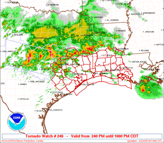
URGENT - IMMEDIATE BROADCAST REQUESTED
TORNADO WATCH NUMBER 249
NWS STORM PREDICTION CENTER NORMAN OK
805 PM CDT FRI JUN 6 2014
THE NWS STORM PREDICTION CENTER HAS ISSUED A
* TORNADO WATCH FOR PORTIONS OF
WESTERN AND NORTHERN OKLAHOMA
* EFFECTIVE THIS FRIDAY NIGHT AND SATURDAY MORNING FROM 805 PM
UNTIL 300 AM CDT.
* PRIMARY THREATS INCLUDE...
A COUPLE INTENSE TORNADOES POSSIBLE
SCATTERED DAMAGING WINDS LIKELY WITH ISOLATED SIGNIFICANT GUSTS
TO 80 MPH POSSIBLE
SCATTERED LARGE HAIL LIKELY WITH ISOLATED VERY LARGE HAIL EVENTS
TO 2 INCHES IN DIAMETER POSSIBLE
THE TORNADO WATCH AREA IS APPROXIMATELY ALONG AND 65 STATUTE
MILES EAST AND WEST OF A LINE FROM 15 MILES NORTH NORTHWEST OF
ALVA OKLAHOMA TO 45 MILES SOUTH SOUTHEAST OF CLINTON OKLAHOMA.
FOR A COMPLETE DEPICTION OF THE WATCH SEE THE ASSOCIATED WATCH
OUTLINE UPDATE (WOUS64 KWNS WOU9).
PRECAUTIONARY/PREPAREDNESS ACTIONS...
REMEMBER...A TORNADO WATCH MEANS CONDITIONS ARE FAVORABLE FOR
TORNADOES AND SEVERE THUNDERSTORMS IN AND CLOSE TO THE WATCH
AREA. PERSONS IN THESE AREAS SHOULD BE ON THE LOOKOUT FOR
THREATENING WEATHER CONDITIONS AND LISTEN FOR LATER STATEMENTS
AND POSSIBLE WARNINGS.
&&
OTHER WATCH INFORMATION...CONTINUE...WW 241...WW 242...WW
243...WW 244...WW 245...WW 247...WW 248...
DISCUSSION...TSTMS NOW OVER THE TX PANHANDLE...AND OTHERS EXPECTED
TO FORM SHORTLY IN NW OK...EXPECTED TO MOVE/DEVELOP GENERALLY
EWD...WITH AN ATTENDANT THREAT FOR DMGG WIND...LARGE HAIL...AND
TORNADOES. ACTIVITY WILL BE PROMOTED BY WAA ASSOCIATED WITH EXIT
REGION OF STRENGTHENING...MOIST...SLY LLJ. ACTIVITY MAY EVOLVE INTO
A COMPLEX MCS CONTAINING LEWPS/BOWING SEGMENTS CAPABLE OF HIGH
WIND/HAIL AND SHORT-LIVED TORNADOES LATER TNGT.
AVIATION...TORNADOES AND A FEW SEVERE THUNDERSTORMS WITH HAIL
SURFACE AND ALOFT TO 2 INCHES. EXTREME TURBULENCE AND SURFACE
WIND GUSTS TO 70 KNOTS. A FEW CUMULONIMBI WITH MAXIMUM TOPS TO
550. MEAN STORM MOTION VECTOR 26030.
Tornadoes
Wind
Probability of 2 or more tornadoes
Probability of 1 or more strong (F2-F5) tornadoes
Hail
Probability of 10 or more severe wind events
Probability of 1 or more wind events > 65 knots
Combined Severe Hail/Wind
Probability of 10 or more severe hail events
Probability of 1 or more hailstones > 2 inches
Probability of 6 or more combined severe hail/wind events
Participating Member
TOR watch NW 1/3rd of OK.
Looks like flash flooding is main threat at the moment as these storm merge together and eventually become a squall line.
David
Upgrade to Moderate Risk
DAY 1 CONVECTIVE OUTLOOK
NWS STORM PREDICTION CENTER NORMAN OK
0758 PM CDT FRI JUN 06 2014
VALID 070100Z - 071200Z
...THERE IS A MDT RISK OF SVR TSTMS FOR THE ERN TX PANHANDLE...NW
OK...S-CNTRL KS...
...THERE IS A SLGT RISK OF SVR TSTMS ACROSS THE CNTRL/SRN PLAINS...
...THERE IS A SLGT RISK OF SVR TSTMS OVER PARTS OF THE SOUTHEAST...
...SUMMARY...
SCATTERED TO WIDESPREAD SEVERE WINDS...LARGE HAIL...AND A FEW
TORNADOES WILL BE MOST LIKELY ACROSS PARTS OF THE SOUTHERN GREAT
PLAINS TONIGHT. ADDITIONAL SEVERE STORMS MAINLY IN THE FORM OF
DAMAGING WINDS WILL PERSIST OVER THE CENTRAL GREAT PLAINS AND
SOUTHEAST STATES THIS EVENING.
...GREAT PLAINS...
SEVERAL SUPERCELLS ACROSS ERN NM INTO THE TX PANHANDLE AND SWRN KS
APPEAR TO BE IN THE PROCESS OF CONSOLIDATING INTO A
FORWARD-PROPAGATING MCS. THIS MCS SHOULD EVOLVE EWD THIS EVENING AS
THE LLJ STRENGTHENS ACROSS WRN/CNTRL TX INTO WRN OK. DOWNSTREAM
STORM DEVELOPMENT WILL LIKELY OCCUR ON A RESIDUAL E/W-ORIENTED FRONT
NEAR THE KS/OK BORDER...ALONG THE 700 MB THERMAL GRADIENT NOTED BY
12 DEG C IN 00Z OUN RAOB VERSUS 8 DEG C IN 00Z LMN RAOB. ONGOING
RISKS OF ALL SEVERE HAZARDS INCLUDING SIGNIFICANT LARGE HAIL AND A
FEW TORNADOES WILL PERSIST FOR AT LEAST THE NEXT FEW HOURS GIVEN
STRONG BUOYANCY AND AN ELONGATED HODOGRAPH SAMPLED BY 00Z AMA RAOB.
THESE RISKS WILL LARGELY TRANSITION TO SEVERE WIND GUSTS AS THE COLD
POOL STRENGTHENS. WITHIN A STEEP LAPSE RATE ENVIRONMENT AND
DOWNSTREAM PLUME OF 60S TO LOWER 70S SURFACE DEW POINTS AMIDST 35-40
KT 500 MB WLYS...BOWING STRUCTURES SHOULD DEVELOP CAPABLE OF INTENSE
WIND GUSTS.
SEVERE WIND GUSTS AND HAIL SHOULD ALSO CONTINUE WITH LINES OF STORMS
FROM S-CNTRL NEB TO NWRN KS THAT WILL LIKELY EVOLVE E/SEWD TONIGHT.
Participating Member
Storm going up in Woodward county is rotating.
David
All 3 storms in NW OK are spinning. Strong rotation between Buffalo and Fort Supply.
Participating Member
Guys, I heard a forecast for tomorrow and I think what I heard for OKC was basically a carbon copy of today. Overnight storms maybe into the morning which will create conditions that would delay evening storms until later Sat night and overnight, wash and repeat for Sunday, maybe Monday. Is that basically how you guys see it? Why this cycle?
Participating Member
Stalled out front that just has these little lows traveling across it in pieces of energy.
This will be wave after wave of storms. The timing is impossible to guess due to each wave leaving stable air behind it, that becomes rapidly unstable if sunshine heating (likely) occurs.
Unless, the state is getting well fixed for a good, overall soaking, you gotta be positioned just right under all those clouds to get something decent. That squall line at mid morning only brought .18" for me in Stillwater. Interesting, though, the map above on post #104 shows Stillwater about in the max bulleye for 8.5".
Also interesting how long time retired KFOR weatherman, Jim Williams, thinks Mike Morgan is the only TV weatherman, who has his act together.
David
MESOSCALE DISCUSSION 0872
NWS STORM PREDICTION CENTER NORMAN OK
1055 PM CDT FRI JUN 06 2014
AREAS AFFECTED...MUCH OF CNTRL OK
CONCERNING...SEVERE POTENTIAL...WATCH LIKELY
VALID 070355Z - 070600Z
PROBABILITY OF WATCH ISSUANCE...95 PERCENT
SUMMARY...A LINE OF SEVERE STORMS WITH A DAMAGING WIND THREAT IS
EXPECTED TO AFFECT MUCH OF OK LATER TONIGHT. A SEVERE THUNDERSTORM
WATCH IS LIKELY BEFORE 5Z.
DISCUSSION...A LINE OF STORMS CONTINUES TO EVOLVE OUT OF THE TX
PANHANDLE AND INTO WRN OK. WIDESPREAD 50-60 MPH WIND GUSTS HAVE BEEN
MEASURED WITH THESE CELLS...WITH A FEW STRONGER GUSTS EARLIER ON.
THE 00Z OUN SOUNDING...AS WELL AS OBJECTIVE ANALYSIS INDICATE
RELATIVELY WARM/DRY PROFILES ALOFT AROUND 700 MB...WITH THE MOST
SUBSTANTIAL CONVECTIVE INHIBITION ACROSS SRN OK INTO TX. HOWEVER...A
INSTABILITY/THETA-E AXIS EXTENDS FROM NWRN ACROSS CNTRL AND SERN OK
WHERE THE HIGHER DEWPOINTS LIE. WITH A STRONG COLD POOL BEHIND THE
NWRN OK ACTIVITY...THESE STORMS SHOULD CONTINUE TO PROPAGATE IN AN
E/SE DIRECTION WITH A THREAT OF SEVERE WIND GUSTS.
..JEWELL/CORFIDI.. 06/07/2014
David
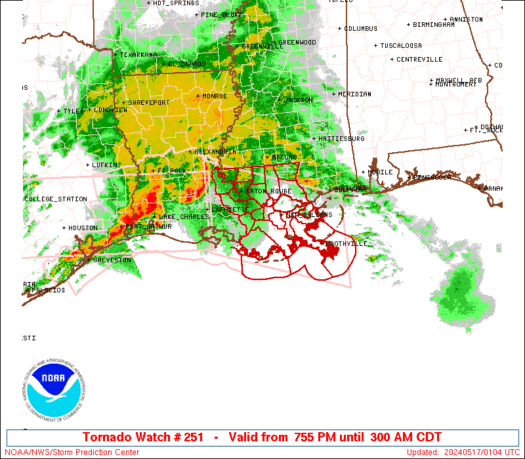
New Watch
BULLETIN - IMMEDIATE BROADCAST REQUESTED
SEVERE THUNDERSTORM WATCH OUTLINE UPDATE FOR WS 251
NWS STORM PREDICTION CENTER NORMAN OK
1125 PM CDT FRI JUN 6 2014
SEVERE THUNDERSTORM WATCH 251 IS IN EFFECT UNTIL 500 AM CDT
FOR THE FOLLOWING LOCATIONS
OKC015-017-019-027-031-033-035-037-049-051-063-067-081-083-087-
091-097-099-101-105-107-109-111-113-117-119-123-125-131-133-137-
141-143-145-147-071000-
/O.NEW.KWNS.SV.A.0251.140607T0425Z-140607T1000Z/
OK
. OKLAHOMA COUNTIES INCLUDED ARE
CADDO CANADIAN CARTER
CLEVELAND COMANCHE COTTON
CRAIG CREEK GARVIN
GRADY HUGHES JEFFERSON
LINCOLN LOGAN MAYES
MCCLAIN MCINTOSH MURRAY
MUSKOGEE NOWATA OKFUSKEE
OKLAHOMA OKMULGEE OSAGE
PAWNEE PAYNE PONTOTOC
POTTAWATOMIE ROGERS SEMINOLE
STEPHENS TILLMAN TULSA
WAGONER WASHINGTON
ATTN...WFO...OUN...TSA...
David
URGENT - IMMEDIATE BROADCAST REQUESTED
SEVERE THUNDERSTORM WATCH NUMBER 251
NWS STORM PREDICTION CENTER NORMAN OK
1125 PM CDT FRI JUN 6 2014
THE NWS STORM PREDICTION CENTER HAS ISSUED A
* SEVERE THUNDERSTORM WATCH FOR PORTIONS OF
SOUTHWEST THROUGH NORTHEAST OKLAHOMA
* EFFECTIVE THIS FRIDAY NIGHT AND SATURDAY MORNING FROM 1125 PM
UNTIL 500 AM CDT.
* PRIMARY THREATS INCLUDE...
WIDESPREAD DAMAGING WINDS LIKELY WITH ISOLATED SIGNIFICANT GUSTS
TO 75 MPH POSSIBLE
ISOLATED LARGE HAIL EVENTS TO 1.5 INCHES IN DIAMETER POSSIBLE
A TORNADO OR TWO POSSIBLE
THE SEVERE THUNDERSTORM WATCH AREA IS APPROXIMATELY ALONG AND 70
STATUTE MILES EAST AND WEST OF A LINE FROM 45 MILES EAST
SOUTHEAST OF FORT SILL OKLAHOMA TO 15 MILES NORTH OF BARTLESVILLE
OKLAHOMA. FOR A COMPLETE DEPICTION OF THE WATCH SEE THE
ASSOCIATED WATCH OUTLINE UPDATE (WOUS64 KWNS WOU1).
PRECAUTIONARY/PREPAREDNESS ACTIONS...
REMEMBER...A SEVERE THUNDERSTORM WATCH MEANS CONDITIONS ARE
FAVORABLE FOR SEVERE THUNDERSTORMS IN AND CLOSE TO THE WATCH
AREA. PERSONS IN THESE AREAS SHOULD BE ON THE LOOKOUT FOR
THREATENING WEATHER CONDITIONS AND LISTEN FOR LATER STATEMENTS
AND POSSIBLE WARNINGS. SEVERE THUNDERSTORMS CAN AND OCCASIONALLY
DO PRODUCE TORNADOES.
&&
OTHER WATCH INFORMATION...CONTINUE...WW 247...WW 248...WW
249...WW 250...
DISCUSSION...WRN OK SQLN WITH EMBEDDED LEWPS AND LOW-AMPLITUDE
BOWS/SUPERCELLS EXPECTED TO CONTINUE GENERALLY EWD THROUGH EARLY
SAT. STRONGEST UPDRAFTS MAY TEND TO BUILD SLIGHTLY S OF E WITH TIME
AS SQLN FURTHER ENCOUNTERS THETA-E GRADIENT/OLD OUTFLOW BOUNDARY
STALLED ROUGHLY WNW-ESE FROM W CNTRL TO S CNTRL OK. UPLIFT IN EXIT
REGION OF 30-35 KT SLY LLJ SHOULD CONTINUE TO PROMOTE STRONG STORM
DEVELOPMENT...WITH FAIRLY HIGH PW /AOA 1.25 IN/ AUGMENTING RISK FOR
DMGG SFC GUSTS. ALSO...A TORNADO OR TWO CANNOT BE RULED OUT IN
ASSOCIATION WITH EMBEDDED MESOVORTICES.
AVIATION...A FEW SEVERE THUNDERSTORMS WITH HAIL SURFACE AND ALOFT
TO 1.5 INCHES. EXTREME TURBULENCE AND SURFACE WIND GUSTS TO 65
KNOTS. A FEW CUMULONIMBI WITH MAXIMUM TOPS TO 600. MEAN STORM
MOTION VECTOR 26030.
Tornadoes
Wind
Probability of 2 or more tornadoes
Probability of 1 or more strong (F2-F5) tornadoes
Hail
Probability of 10 or more severe wind events
Probability of 1 or more wind events > 65 knots
Combined Severe Hail/Wind
Probability of 10 or more severe hail events
Probability of 1 or more hailstones > 2 inches
Probability of 6 or more combined severe hail/wind events
Participating Member
Should I go to sleep or go ahead and wait until these pass?
There are currently 1 users browsing this thread. (0 members and 1 guests)
 Posting Permissions

 Reply With Quote


Bookmarks