Widgets Magazine
Page 5 of 9 FirstFirst 123456789 LastLast
Results 101 to 125 of 211

Thread: Oklahoma Weather Discussion - August 2013

  1. Default Re: Oklahoma Weather Discussion - August 2013

    Per mesonet data...

    Norman annual average 37.39". With last nights rainfall that puts us at 36.63" for the year to date. The wettest since 2007 when 56.09" was received.

    Official reporting site for OKC at WRWA had 43.47" as of last night which compares to an average of 35.85. Based on averages we still have another 11-12 inches to go for the year which would take us to 55.09". All time record is 56.95" so the way it looks right now, unless we dry out completely, we'll probably break that.
    Last edited by venture; 08-09-2013 at 09:15 AM. Reason: Corrected Norman annual to be NWS 30 year avg

  2. #102

    Default Re: Oklahoma Weather Discussion - August 2013

    Just wondering if you have the numbers for the Canton lake area? Was hoping that they would start getting back to normal rains but I think they are still way below average.

  3. #103

    Default Re: Oklahoma Weather Discussion - August 2013

    OKC is up to like 45 inches this year.

  4. Default Re: Oklahoma Weather Discussion - August 2013

    Quote Originally Posted by OKCRT View Post
    Just wondering if you have the numbers for the Canton lake area? Was hoping that they would start getting back to normal rains but I think they are still way below average.
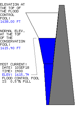
    They've only gained maybe a percentage point up to 22% full.


    Seiling is the nearest mesonet station that is within the watershed area for Canton, as far as I know, and they are only 3 inches away from Normal. So they are seeing a lot of rain, it just isn't making it to the lake.

  5. Default Re: Oklahoma Weather Discussion - August 2013

    Quote Originally Posted by soonerguru View Post
    OKC is up to like 45 inches this year.
    See two posts above yours.

  6. #106

    Default Re: Oklahoma Weather Discussion - August 2013

    Quote Originally Posted by venture79 View Post
    All time record is 56.95" so the way it looks right now, unless we dry out completely, we'll probably break that.
    and all that with no Tropical Storm activity (so far).

  7. #107

    Default Re: Oklahoma Weather Discussion - August 2013

    Quote Originally Posted by venture79 View Post
    Rotation in these situations can be a few things. 1) Potential for hail to start ramping up, 2) Wind increase in strength in a very localized area, and 3) a quick weak spin up.

    If a tornado would happen in this, it would be a weak one and very quick. The wind damage would likely be more widespread and cover things up a bit more. It has come back down some, but still showing winds up to 65 mph.
    Take this for what it's worth...

    https://www.facebook.com/ATsFans/posts/642902569062507

    Aaron Tuttle Meteorologist (weatherman)


    Went through and analyzed some radar data from last night's tornado. It formed at 12:08am and hit the Love's truck stop at I-35/NW 122nd street at 12:09. Then moved ENE across the bridge and to the turnpike before dissipating at 12:11am. So it basically lasted about 4 minutes. It was weak with a max wind speed of around 100 mph when it moved to the east side of the interstate. EF1 category. These types of embedded tornadoes are hard to warn on from the National Weather Service because they are so small and short-lived and sometimes fall within the 4-6 minute low elevation updates from the NEXRAD. It's not the typical tornado that forms from a supercell storm. However, the TDWR provides 60 second updates and they are easier to spot with that faster scan rate and higher native resolution.

    You really have to watch Doppler radar trends second by second at the lowest tilts to catch them. Which is where the TV guys come into play. Those with a live radar that scans the lowest elevation every 10-20 seconds can watch it happen in near real-time (assuming they look at velocity) and tell you as long as they pay attention. Most however do not, as was the case last night. Your loss when that occurs. That's a shame too as that's where you can make a difference. The good news is that these are often weak. The bad news is that they are not always close enough to the radar to be detected, so they do occur quite often, they're just never captured because it's a low level phenomenon that the radar can't see when more than 30 miles away.


  8. Default Re: Oklahoma Weather Discussion - August 2013

    While the radar presentation was definitely very impressive that a tornado was definitely possible last night, I haven't seen anything from NWS Norman to support Tuttle's claim. The radar signature definitely highlighted decently tight rotation, but confirming anything actually touched down will be tough with severe winds also likely occurring at the same time.

    Everyone knows where I stand on Tuttle, so I'll wait for the NWS survey.

  9. #109

    Default Re: Oklahoma Weather Discussion - August 2013

    Why wasn't a tornado warning issued?

  10. #110

    Default Re: Oklahoma Weather Discussion - August 2013

    Quote Originally Posted by Anonymous. View Post
    This will put the central OK region about 4 inches away from the wettest ever.

    Just imagine what the year total is going to be if we are adding this much in August... (just kidding, winter will probably be dry as a bone, lol)
    DON'T SAY THAT!!!!!!! I WANT A COLD SNOWY WINTER!! lol ;P

  11. Default Re: Oklahoma Weather Discussion - August 2013

    Blog post and collection of radar images from last night's feature that developed in NE OKC: August 8th/9th (early AM) OKC Severe Weather | Weather Spotlight

  12. #112

    Default Re: Oklahoma Weather Discussion - August 2013

    saw sarah libby on the channel 4 morning show today (sunday). didn't know she was back on air.

  13. Default Re: Oklahoma Weather Discussion - August 2013

    Slight Risk tomorrow, for right now just northern 2 tiers of counties officially.

    ...KS INTO NRN OK...
    HEAVY RAIN AND STORMS WILL LIKELY BE ONGOING ACROSS SRN KS...AND
    PERHAPS INTO FAR NRN OK MON MORNING...SUPPORTED BY AN EARLY SWLY LOW
    LEVEL JET BUT LIKELY DWINDLING DURING THE LATE MORNING. LATER IN THE
    DAY...HEATING WILL OCCUR S AND W OF THE OUTFLOW...WITH STRONG
    INSTABILITY DEVELOPING FROM WRN/SRN KS INTO NRN/ERN OK. MODEST LOW
    TO MIDLEVEL FLOW WILL EXIST...ALONG WITH RELATIVELY STRONG UPPER
    LEVEL FLOW WITH THE NOSE OF THE UPPER JET. GIVEN THE DEGREE OF
    INSTABILITY...AT LEAST ISOLATED LARGE HAIL AND DAMAGING WINDS APPEAR
    LIKELY ALONG A CORRIDOR NEAR THE BOUNDARY.

  14. #114

    Default Re: Oklahoma Weather Discussion - August 2013

    At least one lake out of the drought zone, which supplies municipal drinking water, has NOT risen to a comfortable level. An example is Lone Chimney Lake, located between Pawnee and Stillwater. That lake seems to have gotten bypassed from the rains worse than Stillwater. Below is a video about it, plus a link to printed news story:

    Lone Chimney Lake remains dangerously low » Local News » Stillwater NewsPress


  15. #115

    Default Re: Oklahoma Weather Discussion - August 2013

    Storms and showers maturing in SW OK and NW TX.

    This is the beginning of a off/on wet week.

  16. #116

    Default Re: Oklahoma Weather Discussion - August 2013

    Showers died just before reaching metro last night.

    Daytime heating today will aid in the front bubbling up over much of OK today. Random storms likely this afternoon.

  17. #117

    Default Re: Oklahoma Weather Discussion - August 2013

    Unfortunately I lost several boxes of stuff with that last rain up there. Who would have thought my old house would have flooded 3 times in less than 3 months in the middle of summer in Oklahoma. Crazy weather and my friends in SE Kansas and SW Missouri are getting it worse and it's raining up there again. It's just been hot and dry here and I'm not complaining one bit.

  18. #118

    Default Re: Oklahoma Weather Discussion - August 2013

    Here is precipitation estimates for this week:


    This image will refresh.


    Flood watches issued for northeastern 1/3 of OK. Does not include OKC metro at this time.

  19. #119

    Default Re: Oklahoma Weather Discussion - August 2013

    Quote Originally Posted by Anonymous. View Post
    Showers died just before reaching metro last night.

    Daytime heating today will aid in the front bubbling up over much of OK today. Random storms likely this afternoon.
    Flash flood watch out for most of the northeast half of Oklahoma until 1am Wednesday. Among major cities it has Tulsa, Stillwater and Enid. But not Oklahoma City.

  20. #120

    Default Re: Oklahoma Weather Discussion - August 2013

    Storms firing with heating north of Clinton and all over TX pandhandle. Should eventually evolve into large MCS tonight and sweep across state.


    No anticipation of a watch, but that storm north of Clinton is mighty stout at the moment.

  21. #121

    Default Re: Oklahoma Weather Discussion - August 2013

    Warning now out on the Clinton storm.

    Also the FloodWatch has been extended south to include the OKC metro.

  22. #122

    Default Re: Oklahoma Weather Discussion - August 2013

    Weak rotation coming up on the Clinton storm as it is taking a supercell structure.

  23. Default Re: Oklahoma Weather Discussion - August 2013


    MESOSCALE DISCUSSION 1704
    NWS STORM PREDICTION CENTER NORMAN OK
    0400 PM CDT MON AUG 12 2013


    AREAS AFFECTED...PORTIONS OF WRN/CNTRL/SRN OK...CNTRL/SRN AR...FAR
    NRN TX


    CONCERNING...SEVERE POTENTIAL...WATCH UNLIKELY


    VALID 122100Z - 122300Z


    PROBABILITY OF WATCH ISSUANCE...5 PERCENT


    SUMMARY...A FEW STORMS COULD BECOME SVR INTO THE LATE AFTERNOON
    HOURS AND EVENING HOURS.


    DISCUSSION...SFC OBS INDICATE A CONVECTIVELY AUGMENTED BOUNDARY
    EXTENDING FROM CNTRL AR WWD INTO SERN OK THAT ALSO ARCS NWWD INTO
    NWRN OK. GREATER CONVECTIVE COVERAGE -- AND ATTENDANT STRONGER/MORE
    WIDESPREAD COLD POOL ORGANIZATION -- ASSOCIATED WITH A MINOR
    MID-LEVEL IMPULSE IS CONTRIBUTING TO MORE NOTABLE SWD/SEWD MOTION OF
    THE BOUNDARY FROM SERN OK INTO CNTRL AR...WHILE THE BOUNDARY IS MORE
    QUASI-STATIONARY NWWD INTO NWRN OK.


    THE AIR MASS HAS BECOME MODERATELY TO STRONGLY UNSTABLE ALONG AND S
    OF THE BOUNDARY...AS SFC TEMPERATURES HAVE CLIMBED INTO THE 90S
    AMIDST DEWPOINTS IN THE UPPER 60S TO THE LOWER 70S. THIS MAY
    CONTRIBUTE TO VIGOROUS UPDRAFTS/DOWNDRAFTS...WITH A FEW STORMS
    POTENTIALLY PRODUCING SVR WIND/HAIL ON A SPORADIC BASIS. THE
    GREATEST POTENTIAL FOR STRONGER STORMS WOULD EXIST INVOF THE
    QUASI-STATIONARY SEGMENT OF THE BOUNDARY FROM CNTRL OK INTO NWRN
    OK...WHERE CONVECTION MAY HAVE A LOWER POTENTIAL TO BE UNDERCUT BY
    THE BOUNDARY.


    HOWEVER...AREA VWP DATA INDICATE THAT STRONGER DEEP SHEAR WILL
    REMAIN RELEGATED TO THE COOL SIDE OF THE SFC BOUNDARY...WHERE
    RELATIVELY MORE STABLE THERMODYNAMIC PROFILES MAY PRECLUDE
    SUSTENANCE OF INTENSE CONVECTION. THE LACK OF OVERLAP OF FAVORABLY
    STRONG SHEAR AND BOUNDARY-LAYER BUOYANCY FOR SUSTAINED/ORGANIZED
    CONVECTION AMIDST ONLY MODEST MID-LEVEL LAPSE RATES MAY LARGELY
    MITIGATE A MORE WIDESPREAD SVR THREAT FROM EVOLVING.


    ..COHEN/KERR.. 08/12/2013

  24. Default Re: Oklahoma Weather Discussion - August 2013

    Here is the severe storm out to the west. Movement SE at 15-20 mph. Track is on the main hail core/inflow area of the storm.


  25. Default Re: Oklahoma Weather Discussion - August 2013

    Outflow boundary passing through Norman now and extends SW towards the area between Lindsay and Alex. It should run into the storm near Chickasha here in the next 15-20 minutes. This is the storm that produced 1" hail over Fort Cobb Lake is weakening right now but maybe we'll get something out of it..

Thread Information

Users Browsing this Thread

There are currently 1 users browsing this thread. (0 members and 1 guests)

Similar Threads

  1. Oklahoma Weather Discussion - July 2013
    By Bunty in forum Weather & Geosciences
    Replies: 208
    Last Post: 08-01-2013, 11:27 AM
  2. Oklahoma Severe Weather Discussion - May 2013
    By venture in forum Weather & Geosciences
    Replies: 1222
    Last Post: 06-06-2013, 10:16 PM
  3. Oklahoma Weather Discussion - January 2013
    By venture in forum Weather & Geosciences
    Replies: 154
    Last Post: 01-31-2013, 06:52 PM
  4. Oklahoma Weather Discussion - August/September 2012
    By venture in forum Weather & Geosciences
    Replies: 143
    Last Post: 09-26-2012, 02:01 PM
  5. Oklahoma Severe Weather Discussion - July & August 2011
    By venture in forum Weather & Geosciences
    Replies: 265
    Last Post: 09-06-2011, 07:29 PM

Bookmarks

Posting Permissions

  • You may not post new threads
  • You may not post replies
  • You may not post attachments
  • You may not edit your posts
  •  
Single Sign On provided by vBSSO