


After a very wet July, the heat is still on for August. August is typically a quiet, hot month for Oklahoma but so far this hasn't be a normal summer. The Fall severe weather season usually kicks off in late September/early October, but we also start seeing increased chances of tropical systems effecting our weather starting this time of year. For those that don't like the high summer heat, it is good to note we are now starting to decent into Fall as average highs start to decrease after August 9th.
Current ConditionsSevere Weather Information
Norman Warning Area Map Tulsa County Warning Area Map Tornado Warning | Tornado Watch | Severe Thunderstorm Warning | Severe Thunderstorm Watch
Red Flag Warning | Fire Warning | Severe Weather Statement | Special Weather Statement
Hazardous Weather Outlook | Fire Weather Watch
Other Color Meanings: Web-Based Watch/Warning/Advisory Map Colors - NOAA's National Weather Service
Oklahoma Mesonet Current Conditions
Red - Air Temp, Green - Dewpoint, Barbs - Wind Speed/Direction, Gray - Gusts, Blue - Precip since Midnight
SPC Convection (Severe Weather) Outlooks
*Click any above graphic to view discussion.*
Day 1 Outlook Tornado Outlook Wind Outlook Hail Outlook
Day 2 Outlook Day 2 Probabilistic Outlook Day 3 Outlook Day 3 Probabilistic Outlook
Days 4 through 8 Outlook
Day 4 Day 5 Day 6 Day 7 Day 8
SPC Severe Weather Reports
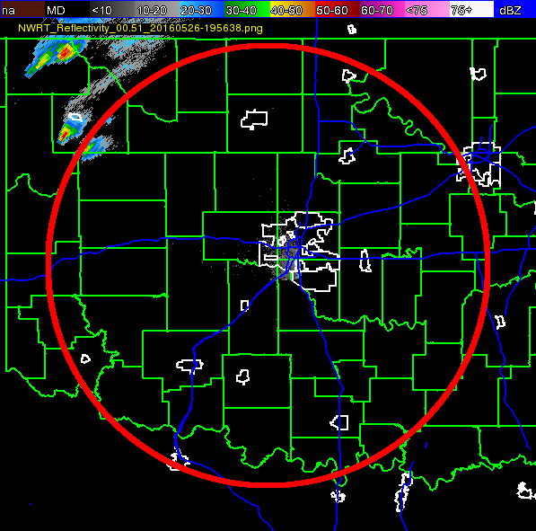
State Radar ImagesState Satellite Images
WSR-88D Twin Lakes WSR-88D Frederick WSR-88D Vance AFB Experimental Test Beds or Specialized Radars
Some experimental products may not always be live or up to date.
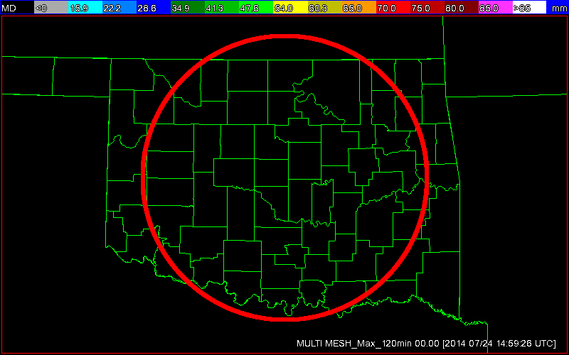
Phased Array Radar (Next Generation Test Bed) Multi-Radar Products
Multi-Radar Hail Core Tracks (Past 120 min) Multi-Radar Maximum Expected Hail Size (MESH)
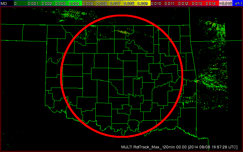
Multi-Radar Products
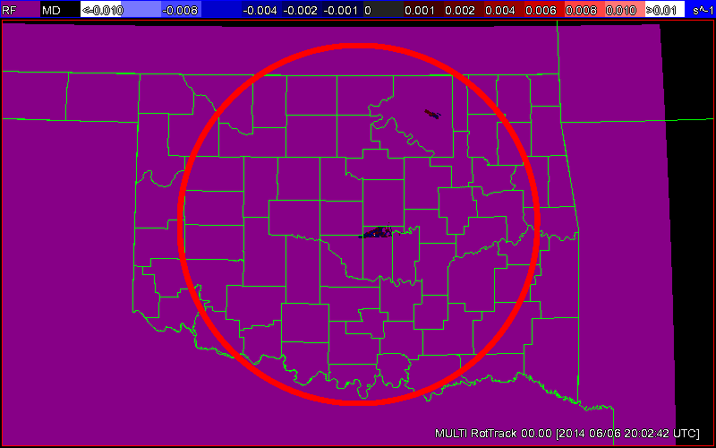
Multi-Radar Rotation Tracks (Past 120 min) Multi-Radar Azimuthal Shear Composite
Oklahoma Mesonet Visible Satellite Image
Image will appear blank overnight.
References
- COD Weather Analysis Page: COD Meteorology -- Surface and Upper Air Data
- NWS Norman Page: NWS
- Storm Prediction Center: Storm Prediction Center
- Oklahoma Mesonet: Mesonet | Home Page
- West Texas Mesonet: Texas Tech University : West Texas Mesonet
- Oklahoma Fire Weather: NWS Norman Fire Weather Forecasts
- Oklahoma Road Conditions: Road Conditions
- Severe Weather Values Reference Guide: The Southern Indiana Weather Spotter's Reference -or- SEVERE WEATHER INDICES PAGE
- TwisterData Model Page: TwisterData.com | Weather Data & Model Forecasts
- Earl Barker's Central US Model Page: Earl Barker's CENTRAL US Model Page
- NSSL WRF Model: NSSL Realtime WRF model Forecasts
- NSSL 4KM WRF Model Forecast Soundings: NSSL 4km WRF Forecast Soundings
- HRRR Rapid Refresh Model: HRRR Model Fields - Experimental
Tutorial: HOW TO VIEW DATA IN HRRR
Step 1) Go the main page: High-Resolution Rapid Refresh (HRRR)
Step 2) Click on 3km HRRR-CONUS hourly
Step 3) Under Domain select SC for South Central US
Step 4) Look at the time frames available. Usually if it isn't through Hour 06 yet, I'll just go up to Date and select the previous time.
Step 5) Depending on what you want to see you can click on the specific time or to loop all the times available you'll see a Check Mark under loop. You can click that to loop them all.
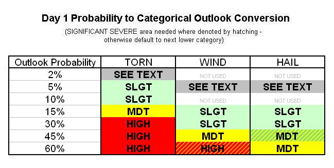
Tutorial: WHAT SPC PERCENTAGES MEANS IN RELATION TO CATEGORICAL RISK LEVEL
Tutorial: HOW TO READ SKEW-T CHARTS
The main Skew-T is your 3 lines with wind barbs on both sides. So the lines first off. Solid is air temp and dashed dewpoint. The dotted line is the temp of the parcel of air as it goes up. So follow that up. If the solid line is to the right of that dotted line that is air that is warmer than that parcel and the parcel won't rise. Also known as your cap. When the air parcel gets warmer than air temp that area between the solid line and dotted line, that is your CAPE. This also shows that the parcel of air will continue to rise up until it meets the air temp again. Here is a good video to help explain it...
Okay so we are looking at that and we can things are going to be unstable with a lot of CAPE. Move of to the wind barbs on the right, that is your wind direction and speed at the various heights. This is also how we detect shear. The two main kinds are going to be speed shear and directional shear. In this exactly we are seeing surface winds out of the SE/SSE, or backed winds as you'll read often, and then they change directions to the SW and WSW as you go up in height. Good example of directional shear. Speed shear is when you have wind speed increase as you go up. We have some of that here as well. All in all this says, good shear. Sometimes you have to be careful of too much shear or speeds being too high in the upper levels because that can just rip updrafts apart.
So we got an unstable atmosphere and wind shear. Finally the squiggly line that is the hodograph. Used to find things like shear vectors and storm relative winds. These are good to help determine if you are going to be dealing with splitting storms and such. Typically in class right turning supercells we look for the hodograph to arch from the center to the right. Which we have here...for the most part. I won't get too much more into it right now, but googling should bring up a ton of resources on it.
So now we get down to the values. A lot of these are open to interpretation and how they play into storm formation, severe storms, and tornadoes. I'm just going to hit on a few of the variables instead of every one, otherwise this will be a book and probably confuse more than need be. Going left to right since these aren't perfect columns.
- LI - Lifted Index. Negative is unstable, usually want lower than -4 for severe.
- KI or K Index you usually want mid 20s for storm development and over 35 for strong development.
- Equil P - That is where your air parcel meets the air temp again after getting warmer than it.
- HAIL - Subjective to this sounding project on estimated hail size.
- ConvT - Convective temperature or air temp needed to break cap without much forcing. This is more important in summer usually.
- Lapse Rates also need to be looked at, in this care the value is favorable for severe weather.
- SRH this is the Storm Relative Helicity in the first kilometer of air from the service...or your low level shear. This is also modified by the direction storms will move. Usually anything over 150 would be pretty significant.
- SWEAT Index helps highlight severe storm potential. Usually 300-500 is what we look for, anything higher is significant.
- TTI or Total Totals is another index looked at for storm development in general. Mid 40s are usually looked at for storm development, anything higher would indicate a more volatile setup.
- Storm Dir/Speed - This is your storm direction in degrees and this is where the storm is coming from. So the example here is ~ 225 degrees which translates into moving NE. Speed is in knots so take the value and multiply by 1.15 to get MPH.
- CapI - Strength of cap. Usually you want 2 or lower to help keep somewhat of a lid on things early. Over 4 requires a nuke to get rid of, less would lead to grunge fest.
- LCL - Lowest cooling level. This is the atmospheric pressure height (measured in millibars) where the air can condense and form clouds. So a high number here means the level is lower to the ground and better chance for surface based convection. If you see numbers lower than say 850 mb, you are talking mostly high based elevated storms. Tornadoes need high LCL values (or lower cooling levels) since they are tied with surface based storms in most cases.
- Sup Potential: Value specific to this product estimating percentage chance if any storm forms that it will be severe.
- Precip Water measures the amount of water in the air. Usually you don't want it more than 1.5 or 1.75 for severe storms otherwise you are looking at just heavy rain. Lower than say 0.75 and its going to be too dry for much precip.
- CAPE most are familiar with. Anything over 0 is unstable. Depending on the season will determine how much you need. Usually anything over 2000 j/kg is very unstable. However as we get into late spring/summer you'll see values over 5000 but not get anything. Even though its extremely unstable, it doesn't do any good without lift or something to break a cap.
- CINH: Convective inhibition. Usually when you start getting lower than -100 you have issues getting anything going.
- 0-1km Shear - Like earlier this is your shear in the first kilometer of air, but this isn't storm direction dependant. When you start getting over 100 to 150 in this department you need to start being vigilant.
- 1km EHI or Energy Helicity Index another way to measure energy/shear. Usually more than 2 or 3 is pretty high.
That's pretty much the main ones without going longer...which I already went a bit too long. We can get more specific about the individual values if more clarification is needed. I went pretty general and with a broad brush on a lot of these. This is mainly to give you an idea of what to look for. The main thing to remember is that so much goes into this, and hopefully this is another example of how much there is, that you can't focus on just a few of these and figure big time storms. Think of it as a recipe. You have to have near perfect amounts of each to get a good tasting soup...otherwise you are just left with a pot full of odd smelling/looking/tasting water.


 Reply With Quote


Bookmarks