


Yeah, as the drought monitor indicates, it's still abnormally dry in Stillwater after all these rains. Boomer Lake still hasn't gone over the spillway as pictured below. Some water is seeping through it, though:
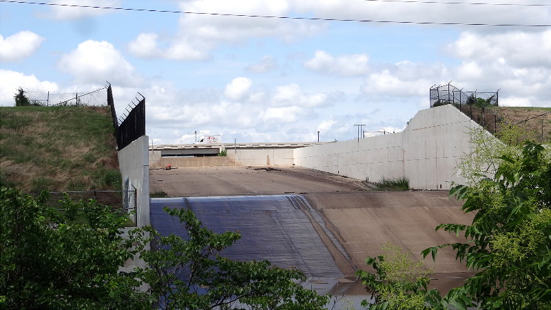

Yeah, as the drought monitor indicates, it's still abnormally dry in Stillwater after all these rains. Boomer Lake still hasn't gone over the spillway as pictured below. Some water is seeping through it, though:
 David
David

El Reno tornado's EF5 rating needs closer look, NWS official says | Tulsa World
Main point of the article is that they are going to continue to look at the El Reno tornado rating. There has yet to be any ground damage verification to support the EF5 rating. Greg Carbin in the article is a meteorologist with SPC in Norman.
I would not be shocked if this one gets knocked back down.
Participating Member
NEW! This Sat (6/8) @MidlandUSA is hosting a NOAA Weather Radio Day in Moore, 9am-2pm, SW 19th #Walmart #okwx http://pbs.twimg.com/media/BMGgMkmCcAAlkYY.png
Participating Member

News9 has the temps going up into the mid 90s next week. Are we going to be in the 100s shortly after?Originally Posted by venture79

Participating Member
I hate to be a buzzkill here but I was a triage nurse at a local ER when 99 tornado went through. A man doing just what you described ended up dying. A projectile penetrated the mattress and entered his midsection, mattress innards and all. Since that night, Im underground or out of the way completely....
Participating Member
We were probably in the same section. I was at a house across the street from a mauled Tundra. I dont know how many houses were in that area from school to the main drag but I counted 5 that had a mid section left( and they stuck out like sore thumbs)....and that was all..the biggest about 5x10. Some were bathtubs, a couple closets and a couple that were obviously the kitchen's pantry....but nothing else....everything else leveled to foundation....everything...
Participating Member
You’re very smart.
Something that you may know more about that I think goes way under reported is injuries that people live with that are sometimes very costly and painful for life.
If you don’t have a safe room / underground shelter and have plenty of time it’s always better if you can get out of the way….because surviving doesn’t automatically always mean getting on with your life as fully capable as you once were.
Sounds like a great thing to do. Speaking of NOAA weather radio, Wunderground has a network of online streaming NOAA weather radio stations. Oklahoma has at least 3 or 4. National directory of them is at Wunder Radio Directory | Weather Underground
So you're saying the vast majority of people will survive in a closet or bathtub if their domicile receives EF-5 damage? Have you seen EF-5 damage up close? I think your central point is true: in the vast majority of tornadoes, an interior room will do it MOST OF THE TIME. But EF-5 damage is catastrophic and extreme. It is dangerous to suggest this to people and provide them with a false sense of safety. Folks in tornado alley need to be thinking of getting storm shelters for their homes -- or consider evacuating on "high-end" severe days. We only have a few of them each year.
David
Slight Risk today mainly NW 1/3rd of OK. Main risks hail and wind.
AY 1 CONVECTIVE OUTLOOK
NWS STORM PREDICTION CENTER NORMAN OK
0748 AM CDT SAT JUN 08 2013
VALID 081300Z - 091200Z
...THERE IS A SLGT RISK OF SVR TSTMS THIS AFTN AND EVE ACROSS PARTS
OF THE CENTRAL AND SOUTHERN PLAINS...
...SYNOPSIS...
A BELT OF MODESTLY STRONG MID/UPPER FLOW...INCLUDING THE REMNANTS OF
ANDREA...AND AN UPSTREAM IMPULSE NOW MIGRATING NORTHEASTWARD THROUGH
THE MID ATLANTIC COAST STATES...APPEARS LIKELY TO GRADUALLY SHIFT
FROM THE NORTHWESTERN THROUGH NORTHERN PERIPHERY OF SUBTROPICAL
RIDGING CENTERED OVER THE WESTERN ATLANTIC TODAY. AS THIS
OCCURS...MODELS SUGGEST UPPER RIDGING WILL BEGIN TO EXPAND WESTWARD
INTO THE SOUTH ATLANTIC COAST STATES AND EASTERN GULF OF MEXICO.
AT THE SAME TIME...MODELS INDICATE THAT A STRONG UPPER JET EMERGING
FROM THE PACIFIC WILL CONTINUE TO NOSE INLAND ALONG THE WESTERN
CANADIAN/U.S. BORDER. WHILE THIS REGIME WILL REMAIN MORE OR LESS
ZONAL IN NATURE...AN IMPULSE EMANATING FROM IT IS IN THE PROCESS OF
DIGGING TO THE LEE OF THE ROCKIES...AND WILL CONTRIBUTE TO
SHARPENING UPPER TROUGHING OVER THE CENTRAL PLAINS LATER TODAY INTO
TONIGHT.
...MID MO VALLEY INTO THE SRN HIGH PLAINS/TEXAS BIG BEND REGION...
IN ASSOCIATION WITH THE AMPLIFYING UPPER TROUGH...MODELS INDICATE
THE CONTINUED DEVELOPMENT AND SOUTHEASTWARD PROGRESSION OF A LOW/
MID-LEVEL CYCLONE OVER THE MID MISSOURI VALLEY REGION TODAY. THIS
FEATURE...AND SURFACE TROUGHING EXTENDING SOUTH SOUTHWESTWARD
THROUGH THE SOUTHERN HIGH PLAINS AND SOUTHWEST TEXAS...ARE EXPECTED
TO PROVIDE THE FOCUS FOR CONSIDERABLE THUNDERSTORM ACTIVITY DURING
THIS PERIOD. A SIGNIFICANT MOISTURE RETURN FROM THE GULF OF MEXICO
IS UNLIKELY. HOWEVER...MID/UPPER 50S SURFACE DEW POINTS NOW PRESENT
ACROSS MUCH OF THE CENTRAL AND SOUTHERN PLAINS...COUPLED WITH SOME
FURTHER INCREASE DUE TO EVAPOTRANSPIRATION...PROBABLY WILL SUPPORT
WEAK TO MODERATE CAPE IN THE PRESENCE OF STEEP LOW/MID LEVEL LAPSE
RATES ACROSS PARTS OF THE CENTRAL PLAINS INTO THE TEXAS PANHANDLE.
VERTICAL SHEAR ACROSS THIS REGION APPEARS LIKELY TO BE SUPPORTIVE OF
ORGANIZED STORM DEVELOPMENT...INCLUDING SUPERCELLS. TORNADIC
POTENTIAL REMAINS A BIT UNCLEAR. LARGE CLOCKWISE CURVED LOW-LEVEL
HODOGRAPHS ARE EXPECTED NEAR A 30-40 KT SOUTHERLY LOW-LEVEL JET
ACROSS CENTRAL KANSAS INTO THE MID MISSOURI VALLEY...WHERE MID TO
HIGH LEVEL FLOW LIKELY WILL REMAIN RELATIVELY WEAK. STRONGER
MID/UPPER FLOW SUPPORTIVE OF LONGER HODOGRAPHS WILL BE FOCUSED
ACROSS PARTS OF SOUTHWEST KANSAS INTO THE OKLAHOMA/TEXAS PANHANDLE
REGION...WHERE LOW-LEVEL HODOGRAPHS MAY REMAIN SOMEWHAT SMALL UNTIL
MID TO LATE EVENING. REGARDLESS...THERMODYNAMIC PROFILES WILL
MOSTLY BE CHARACTERIZED BY SIZABLE LOWER/MID TROPOSPHERIC
TEMPERATURE-DEW POINT SPREADS...WHICH PROBABLY WILL RESULT IN THE
TENDENCY FOR CONVECTIVE OUTFLOW TO QUICKLY UNDERCUT ANY DEVELOPING
MESOCYCLONES. AS A RESULT...LARGE HAIL AND STRONG WIND GUSTS APPEAR
THE PRIMARY SEVERE WEATHER THREATS.
David
Sorry a little late on this. Wanted to get the yard mowed before more rain.
URGENT - IMMEDIATE BROADCAST REQUESTED
SEVERE THUNDERSTORM WATCH NUMBER 288
NWS STORM PREDICTION CENTER NORMAN OK
330 PM CDT SAT JUN 8 2013
THE NWS STORM PREDICTION CENTER HAS ISSUED A
* SEVERE THUNDERSTORM WATCH FOR PORTIONS OF
CENTRAL AND SOUTHERN KANSAS
WESTERN OKLAHOMA AND THE OKLAHOMA PANHANDLE
WEST TEXAS AND THE TEXAS PANHANDLE
* EFFECTIVE THIS SATURDAY AFTERNOON AND EVENING FROM 330 PM UNTIL
1100 PM CDT.
* PRIMARY THREATS INCLUDE...
SEVERAL LARGE HAIL EVENTS LIKELY WITH A FEW VERY LARGE HAIL
EVENTS TO 2 INCHES IN DIAMETER POSSIBLE
SEVERAL DAMAGING WIND GUSTS TO 70 MPH LIKELY
A FEW TORNADOES POSSIBLE
THE SEVERE THUNDERSTORM WATCH AREA IS APPROXIMATELY ALONG AND 75
STATUTE MILES EAST AND WEST OF A LINE FROM 35 MILES NORTHWEST OF
SALINA KANSAS TO 60 MILES SOUTH OF AMARILLO TEXAS. FOR A
COMPLETE DEPICTION OF THE WATCH SEE THE ASSOCIATED WATCH OUTLINE
UPDATE (WOUS64 KWNS WOU8).
PRECAUTIONARY/PREPAREDNESS ACTIONS...
REMEMBER...A SEVERE THUNDERSTORM WATCH MEANS CONDITIONS ARE
FAVORABLE FOR SEVERE THUNDERSTORMS IN AND CLOSE TO THE WATCH
AREA. PERSONS IN THESE AREAS SHOULD BE ON THE LOOKOUT FOR
THREATENING WEATHER CONDITIONS AND LISTEN FOR LATER STATEMENTS
AND POSSIBLE WARNINGS. SEVERE THUNDERSTORMS CAN AND OCCASIONALLY
DO PRODUCE TORNADOES.
&&
DISCUSSION...TSTMS EXPECTED TO FORM AND/OR INCREASE IN
COVERAGE/STRENGTH DURING THE NEXT FEW HOURS ALONG DEEP WIND
SHIFT/COLD FRONT IN KS ASSOCIATED WITH AMPLIFYING NEB UPR VORT.
ADDITIONAL STORMS MAY FORM ALONG LEE TROUGH/DRY LINE SWD INTO W
CNTRL TX. 40-50 KT DEEP NWLY SHEAR...WITH A LARGE...DEEP DIRECTIONAL
COMPONENT SHOULD PROMOTE DEVELOPMENT OF A FEW SUPERCELLS WITH LARGE
HAIL/HIGH WIND AND POSSIBLY A TORNADO OR TWO. THE STORMS SHOULD
ORGANIZE INTO A E/SE-MOVING LINE OR TWO BY EARLY EVE...WITH A
CONTINUING RISK FOR SVR WIND/HAIL.
AVIATION...A FEW SEVERE THUNDERSTORMS WITH HAIL SURFACE AND ALOFT
TO 2 INCHES. EXTREME TURBULENCE AND SURFACE WIND GUSTS TO 60
KNOTS. A FEW CUMULONIMBI WITH MAXIMUM TOPS TO 500. MEAN STORM
MOTION VECTOR 28025.
Participating Member
Dang, I was wanting to put mowing off till tomorrow.....better get busy I guess
You just had to mention postponed mowing, didn't you . . . =)
Participating Member
I got it done, the edging will have to wait though...
Good light show out there tonight!
I guess my mowing will have to wait until about Tuesday . . . Had to work today and again tomorrow and Monday. Right after I do the front "lawn" =) which should warm the break-in oil in the new Toro "assisted push" mowing machine enough to change it I will attack the stack in the back. Estimated time to "completion" thirty minutes max. If it don't rain again. =) You're right: Good Light Show tonight.
Thanks, again to Venture and all that you do.
(it ain't gonna rain on Tuesday is it? please say that it ain't . . . =)
Seriously: I take your work in this area at least twice as seriously as the stuff pouring in on the TV.
Participating Member
Right as this thing moved through, I got a stuffy and runny nose.. I hate allergies.
Participating Member
Glad I mowed Friday
Participating Member
Venture79 or Anonymous. (or anybody else) do you know the criteria that must be meet to issue a PDS tornado watch?
And if you do please explain in the simplest way you can?
Participating Member
Hi ou48A,
I have wondered the same thing. But leading up to those Friday night storms, I believe one of the meteorologists said it's rather arbitrary and up to the SPC meteorologists to use their experience and collaboration with others as the determining factor. In other words, there is no real yardstick or this has to hit that to actually trigger a PDS. Somebody correct me if I'm wrong, I'm just passing on what was said around Wednesday or Thursday of that week.
Participating Member
Never mind, but thanks.
Particularly dangerous situation - Wikipedia, the free encyclopedia
PDS tornado watches are issued when there is a higher than normal risk of multiple strong, violent tornadoes in the watch area (usually amounting to damage consistent with EF4 or EF5 tornadoes), also including significant wind and hail damage, when in addition to tornadoes. While there are no set criteria for a PDS watch to be issued, they are usually issued when the potential exists for a major tornado outbreak.
Participating Member
Thanks.... apparently what you say is correct.
David
There isn't any firm criteria, but typically you are looking at a more high end day when it comes to coverage. If the expectation for multiple strong or violent tornadoes, they'll go with a PDS redbox. I know you didn't ask, but on the flip side...a PDS Severe (blue box) will be put up when a high end Derecho is expected.
Like Zoo said, at the end of the day it is the call of that forecaster at SPC who is putting it together. When we see the probability forecast, I think when looking at the Strong tornado portion...the threshold is going to be 60% or higher on the PDS watches - at least going by this year. 50% or lower, even when the general tornado probability is high, tends to stay a general red box.
So it all comes down to expected coverage. May 31st had the potential to be much more widespread but we saw the convection south of I-40 in SW OK just fade and not get very well established.
Participating Member
Looks like we are getting our first taste of summer this week. 90s and approaching 100s with little to no chance of precip.
You may now proceed to kick anyone who complained about it being "too rainy and cool".
David
Nah. We should just make them pay our electric bill.
Participating Member
I vote for BOTH!
There are currently 1 users browsing this thread. (0 members and 1 guests)
 Posting Permissions

 Reply With Quote

Bookmarks