

Not sure...maybe wind damage?Originally Posted by silvergrove


 David
David

Not sure...maybe wind damage?
Hi, everyone. I never got back onto Venture's chatroom last night, but we were in the cellar at my mom's house for over two hours with sirens blaring and funnels sighted all around her home. Minimal fence damage at her house (a couple of panels), but I did sustain significant damage to my wonderful maple tree in my front yard. The tree was blown by what must have been *incredible* straight-line north winds. The leaves on the tree's surviving limbs are bent to the south. We all just spent the better part of a couple of hours cleaning away the dead limbs.
We were very fortunate. Don't know enough about trees to guess whether it can survive the damage, but if our worst loss is that tree, we're miles ahead of folks who lost everything.
Hope everyone is well.
David
Good to hear you guys are safe Dave. Sorry to hear about the maple, at least it wasn't more like you said.
VIP Member
I appreciate those of you who understand that flash flooding can happen anywhere in a storm like last night's. ou48A, do you even understand sympathy? Or empathy? Enjoy your house on a hill. We aren't all as smart as you, I guess. Seeing as we live in a mostly flat city with a lot of creeks, rivers, and lakes.
Also, this is the very first home I've ever owned. I think I'm afforded a couple of mistakes. Number one being the fact that we bought it, but yeah, we have done everything to control flooding but when you get nearly 8" in a matter of a few hours, there isn't much you can do. This is still my home. It's just a little wetter than normal, that's all.
Still corrupting young minds
Participating Member
I've been meaning to clean the carport but now it's all clean lol
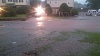
My front yard last night
David
US National Weather Service Norman Oklahoma
29 minutes ago
NEW: EF0 tornado track identified in Moore, just west of I-35, and just north of Moore Medical Center. This minor damage occurred just outside the damage path of the May 20th tornado!
David
NWS Norman @NWSNorman 13m
SURVEY UPDATE: Crews are still out. Still nothing higher than EF3 on the El Reno tornado. Still looking.
NWS Norman @NWSNorman 12m
SURVEY UPDATE: not complete, but appears tornado began near SW 15th and Morgan Road and moved SE. Survey ongoing.
NWS Norman @NWSNorman 1m
Today's surveys are more complicated than last week's. We can confirm at least five tornadoes, and there will probably be more.
NEW: SW OKC Tornado. EF1. 10.4 mile path from SW 15th and Morgan Rd across Will Rogers Airport to near I240 and Western
David
Latest Update...
PUBLIC INFORMATION STATEMENT
NATIONAL WEATHER SERVICE NORMAN OK
350 PM CDT SAT JUN 1 2013
...UPDATE ON MAY 31 SEVERE WEATHER...
A LARGE...SLOW-MOVING CLUSTER OF SUPERCELL THUNDERSTORMS MOVED ACROSS
CENTRAL AND NORTHERN OKLAHOMA THE LATE AFTERNOON AND EVENING OF
FRIDAY... MAY 31. THE NATIONAL WEATHER SERVICE IN NORMAN DISPATCHED
THREE DAMAGE SURVEY CREWS TO VARIOUS PARTS OF THE OKLAHOMA CITY AREA
TO DETERMINE THE NATURE AND EXTENT OF THESE STORMS. REPORTS FROM
THESE TEAMS FOLLOW.
...UPDATES...
1/ ADDED SOUTHEAST OKLAHOMA CITY EF0 TORNADO.
2/ ADDED MOORE EF0 TORNADO.
3/ ADDED SOUTHWEST OKLAHOMA CITY EF1 TORNADO AND MOORE TORNADO TIME.
...MAY 31 SOUTHEAST OKLAHOMA CITY TORNADO /OKLAHOMA COUNTY/...
RATING: EF0
PATH LENGTH: 0.4 MILES
PATH WIDTH /MAXIMUM/: 200 YARDS
TIME: 7:33 PM TO 7:40 PM
LOCATION: CREEKWOOD TERRACE TO KEITH DRIVE
/EAST OF VALLEY BROOK/.
...MAY 31 MOORE TORNADO /CLEVELAND COUNTY/...
RATING: EF0
PATH LENGTH: 0.5 MILES
PATH WIDTH /MAXIMUM/: 500 YARDS
TIME: 7:50 PM TO 7:55 PM
LOCATION: NW 5TH STREET TO W MAIN STREET.
...MAY 31 SOUTHWEST OKLAHOMA CITY TORNADO /CANADIAN AND
OKLAHOMA COUNTIES/...
RATING: EF1
PATH LENGTH: 10.4 MILES
PATH WIDTH /MAXIMUM/: 1.4 MILES
TIME: 6:51 PM TO 7:23 PM
LOCATION: FAIFAX LANE /NORTHWEST OF SW 15TH AND
MORGAN ROAD INTERSECTION/ TO INTERSECTION
OF SW 56TH AND BLACKWELDER AVE.
David
Two more...one we already know about...
...MAY 31 LIGHTNING CREEK PARK EF1 TORNADO /OKLAHOMA COUNTY/...
RATING: EF1
PATH LENGTH: 0.4 MILES
PATH WIDTH /MAXIMUM/: 250 YARDS
TIME: 6:25 PM TO 6:30 PM
LOCATION: LIGHTNING CREEK PARK /STRAKA TERRACE AND
WESTERN AVE/.
...MAY 31 EL RENO EF3 TORNADO /CANADIAN COUNTY/...
RATING: EF3
PATH LENGTH: TO BE DETERMINED
PATH WIDTH /MAXIMUM/: TO BE DETERMINED
TIME: TO BE DETERMINED
LOCATION: SOUTHWEST TO SOUTHEAST OF EL RENO.
The poster formerly known as cleanskull
My backyard maple is no longer the tallest around. OG&E did a good job of getting power back on in Mustang. Missing some shingles.
Participating Member
I was several miles south of Mustang and though I could see a tornado though the haze?
But it wasn’t a clear view.
I was concerned that it might grow and head into the Moore Norman area.
The poster formerly known as cleanskull
I had bailed with the wife and ferret and started heading south and west. I would stop somewhere and they would holler twister. Ended up in Anadarko. Took forever to get back home. Couldn't sleep without my cpap running. 10 min naps and wake up. Going to sleep like a drunk baby tonight.
The poster formerly known as cleanskull
It was the getting back that was so slow. So many stoplights out. Passing all the windmill power towers was interesting last night. Mostly dark with blinking red lights on them. I heard them saying on the radio that the interstates were like a parking lot.
Participating Member
Even well away from OKC the interstates and many other state roads were like parking lots. I have an atlas map of all the county roads in Oklahoma. I used it to navigate the back roads, but many of them were still pretty crowed. I think my days of storm chasing even from a very safe distance are over. There were just too many dangerous drivers.
The poster formerly known as cleanskull
The Oklahoma Atlas and Gazetter is a handy little thing to have. The back roads I headed out on were to flooded to come back on, that and a tree across one made me stick to state highways.
Administrator


people... wish i could've been here yesterday to handle these off-topic posts sooner. again, let's leave any drama out of this thread. thanks. -M
Administrator
lots of off topic posts removed... if you want to debate where you think folks should live, start another thread. -M
Participating Member
Sad news...just saw a release that 3 of those killed in El Reno were storm chasers. One was the well known and renowned Tim Samaras from the Discovery show Storm Chasers. His son and a crew member were also killed. Tim was considered one of the safest and most cautious of chasers. Sad, sad, beyond sad. I really admired Tim and his work.
Participating Member
I saw that too.... Storm chasers among Oklahoma fatalities - CNN.com
Participating Member
Word is now that they were killed when they got "stuck in storm chaser convergence." Nice way of saying too many chasers on some small county road and they couldn't get out of the way. Sad
Participating Member
Can someone please explain why the EF scale starts at 0 and not 1? Sorry if this is such an elementary question.
David
The increasing chaser convergence is one of the reasons I put the keys, laptop, and ham radio up a few years ago. When I started in the mid 90s it would be you and maybe a couple other guys out there on a storm. No congestion on the roads and you also had to use your head - mobile radar was rare you had people that would nowcast you into position. GPS wasn't completely common yet...Delorme Oklahoma atlas and Roads of Texas were the tools there. It came down to know storm struction, envisioning what you think it was going to do, and then enact your plan.
Today it seems it is more about get your HD camera with boom mic ready and your laptop with radar and video streaming capabilities connected to mobile wifi. People spend too much time looking at the screen than at the sky. From what I know, Tim was definitely one of the more cautious and experienced guys out there. Definitely nothing like the new crop of kids I saw pop up about 10 years ago who seem to be more into it for the thrill than the enjoyment of nature and providing valuable reports back through the proper channels. Around 2007 chasing in Texas was when I noticed things were just going to get too dangerous out there. Not from the storms...from the vast number of people who've taken on the hobby.
Participating Member
I wonder if storm chasers need to be licensed and if you're out there without one you get a big fine.
David
Dr. Fujita started it at F0 (now EF0) to signify those tornadoes are going to produce little to no damage. Granted the scale itself today is mostly a damage scale, but if you get a weak tornado touch down in a wheat field you are going to get some swirls in the grass/wheat and that's about it.
Most may, or may not, know that the original scale did go to F12 which is Mach 1. It was never intended that a tornado would get that strong. Good chart I found on Wiki to so the relation...
Interesting to note the original F0 tornado had estimated winds from 40-72 mph, which is pretty much our typical "light breeze" here in Oklahoma.This was updated to 65-85 mph however.
Here are the tables to help compare...
cale Estimated wind speed*[3] Relative frequency[citation needed] Average Damage Path Width (meters)[citation needed] Potential damage[3] mph km/h F0 4072 64116 38.9% 1050 (approx. 32-164 ft ) Light damage.Some damage to chimneys; branches broken off trees; shallow-rooted trees pushed over; sign boards damaged. F1 73112 117180 35.6% 30150 (approx. 98-493 ft) Moderate damage.The lower limit is the beginning of hurricane wind speed; peels surface off roofs; mobile homes pushed off foundations or overturned; moving autos pushed off the roads; attached garages may be destroyed. F2 113157 181253 19.4% 110250 (approx. 360-820 ft) Significant damage.Roofs torn off frame houses; mobile homes demolished; boxcars overturned; large trees snapped or uprooted; highrise windows broken and blown in; light-object missiles generated. F3 158206 254332 4.9% 200500 (approx.655ft- 1/3 mile) Severe damage.Roofs and some walls torn off well-constructed houses; trains overturned; most trees in forest uprooted; heavy cars lifted off the ground and thrown. F4 207260 333418 1.1% 400900 (approx. 1/4-1/2 mile) Devastating damage.Well-constructed houses leveled; structures with weak foundations blown away some distance; cars thrown and large missiles generated. F5 261318 419512 <0.1% 1100 ~(approx. 3/4 mile or more) Incredible damage.Strong frame houses lifted off foundations and carried considerable distances to disintegrate; automobile sized missiles fly through the air in excess of 100 m (109 yd); trees debarked; steel reinforced concrete structures badly damaged.
Scale Wind speed
(Estimated)[4]Example of damage mph km/h m/s EF0 6585 104137 2937 EF1 86110 138177 3849 EF2 111135 178217 5060 EF3 136165 218266 6173 EF4 166200 267322 7490 EF5 >200 >322 >90
EF0 EF1 EF2 EF3 EF4 EF5 Weak Strong Violent Significant Intense
David
We don't need LEOs pulling people over during a tornado when it is in progress. In my opinion it would be better to go after irresponsible chasers who knowingly violate road laws and post documented video proof online for all to see. Of course I'm not sure of the legalities of that, but that's for another thread I think.
There are currently 1 users browsing this thread. (0 members and 1 guests)
 Posting Permissions

 Reply With Quote
 But also glad to know that the important things are okay. We're trying to remember that here as we dry out.
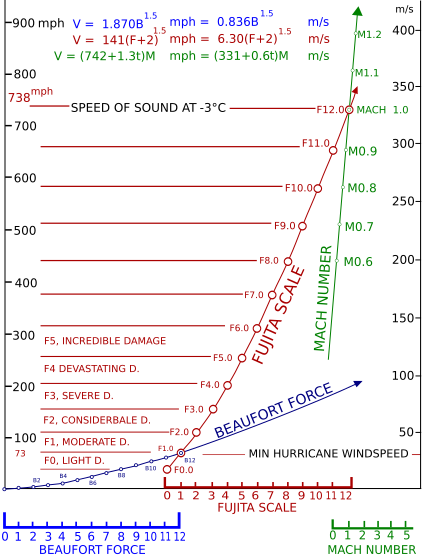


.jpg)

.jpg)


Bookmarks