

This is funny.

 Participating Member


This is funny.
David
NWS Norman @NWSNorman2m
Don't be surprised to see sub-freezing svr t-storm warnings tonight! Frzg rain and severe hail at the same time in spots! #okwx
Banned
I totally agree they are fascinating. I haven't studied meteorology, but I can appreciate the complexity (degree in applied math).Originally Posted by ZYX2

David
Looks like SW OK is finally going to go.
Cells popping up now from Minco back to west of Lawton. Storm down in Baylor Co TX is now severe.
Banned
I do follow them during "risky" days because you guys are awesome.It just seems like some posters are actually dissapointed when there is not massive hail and tornadoes.
Participating Member
https://twitter.com/NWSNorman
NWS Norman@NWSNorman1h
Parts of Oklahoma are 50-60 degrees colder than they were at this time yesterday! #okwx pic.twitter.com/6fRLMa64M9
Participating Member
Sounds like a severe thunderstorm watch can be expected shortly based on the latest tweet from the NWS. Having elevated severe thunderstorms over a near- or sub-freezing surface layer is just ridiculous. I love the Plains, lol.
David
Cell near Medicine Park and another near Grandfield now, both below severe levels. Cell north of Gage in NW OK may be severe shortly.
David
OUN WW 86 SEVERE TSTM KS OK TX 092235Z - 100600Z http://1.usa.gov/bjHcdO?OUN
WW 86 SEVERE TSTM KS OK TX 092235Z - 100600Z
AXIS..75 STATUTE MILES EAST AND WEST OF LINE..
35SSW SPS/WICHITA FALLS TX/ - 45N HUT/HUTCHINSON KS/ ..AVIATION COORDS.. 65NM E/W /30SSW SPS - 17SW SLN/ HAIL SURFACE AND ALOFT..2 INCHES. WIND GUSTS..60 KNOTS.
MAX TOPS TO 500. MEAN STORM MOTION VECTOR 23035.
OKLAHOMA COUNTIES INCLUDED ARE ALFALFA BECKHAM BLAINE CADDO CANADIAN CLEVELAND COMANCHE COTTON CUSTER DEWEY ELLIS GARFIELD GARVIN GRADY GRANT GREER HARMON HARPER JACKSON JEFFERSON KAY KINGFISHER KIOWA LINCOLN LOGAN MAJOR MCCLAIN NOBLE OKLAHOMA PAYNE POTTAWATOMIE ROGER MILLS STEPHENS TILLMAN WASH!TA WOODS WOODWARD
URGENT - IMMEDIATE BROADCAST REQUESTED
SEVERE THUNDERSTORM WATCH NUMBER 86
NWS STORM PREDICTION CENTER NORMAN OK
535 PM CDT TUE APR 9 2013
THE NWS STORM PREDICTION CENTER HAS ISSUED A
SEVERE THUNDERSTORM WATCH FOR PORTIONS OF
CENTRAL KANSAS
CENTRAL AND WESTERN OKLAHOMA
WESTERN NORTH TEXAS
EFFECTIVE THIS TUESDAY AFTERNOON AND WEDNESDAY MORNING FROM 535
PM UNTIL 100 AM CDT.
WIDESPREAD LARGE HAIL
ISOLATED HAIL TO 2.0 INCHES IN DIAMETER POSSIBLE
THE SEVERE THUNDERSTORM WATCH AREA IS APPROXIMATELY ALONG AND 75
STATUTE MILES EAST AND WEST OF A LINE FROM 35 MILES SOUTH
SOUTHWEST OF WICHITA FALLS TEXAS TO 45 MILES NORTH OF HUTCHINSON
KANSAS. FOR A COMPLETE DEPICTION OF THE WATCH SEE THE ASSOCIATED
WATCH OUTLINE UPDATE (WOUS64 KWNS WOU6).
REMEMBER...A SEVERE THUNDERSTORM WATCH MEANS CONDITIONS ARE
FAVORABLE FOR SEVERE THUNDERSTORMS IN AND CLOSE TO THE WATCH
AREA. PERSONS IN THESE AREAS SHOULD BE ON THE LOOKOUT FOR
THREATENING WEATHER CONDITIONS AND LISTEN FOR LATER STATEMENTS
AND POSSIBLE WARNINGS. SEVERE THUNDERSTORMS CAN AND OCCASIONALLY
DO PRODUCE TORNADOES.
DISCUSSION...SCATTERED THUNDERSTORMS ARE EXPECTED TO INTENSIFY THIS
AFTERNOON AND EVENING OVER THE WATCH AREA. STORMS WILL BE BEHIND A
STRONG SURFACE COLD FRONT. BUT DESPITE THE VERY COLD LOW LEVEL
ENVIRONMENT...FORECAST SOUNDINGS SHOW AMPLE ELEVATED INSTABILITY AND
SHEAR FOR ROTATING THUNDERSTORMS CAPABLE OF LARGE HAIL. COVERAGE OF
STORMS MAY CONTINUE TO INCREASE THROUGH MIDNIGHT.
AVIATION...A FEW SEVERE THUNDERSTORMS WITH HAIL SURFACE AND ALOFT
TO 2 INCHES. EXTREME TURBULENCE AND SURFACE WIND GUSTS TO 60
KNOTS. A FEW CUMULONIMBI WITH MAXIMUM TOPS TO 500. MEAN STORM
MOTION VECTOR 23035.
Participating Member
I can't recall ever seeing a severe tstorm watch in sub-freezing air.
Participating Member
In about 1972/1973 or so there was a documented tornado in southern Oklahoma that occurred while it was sleeting.
Participating Member
This is sort of scary... The probability of getting greater than half an inch of ice has appeared. Before it was just .25".

Participating Member
I was just outside during the instant temperature drop. Pretty cool! ... no pun intended.
Maybe it is The Weather Apocalypse predicted on the Inca Calendar.
Perhaps PPanda has exactly the right plants to enhance the viewing of The Event.
(from the rosetta stone of obscure references: refer to post 200 ^^^)
Did I hear someone placing bets on weather events?
Has the Elks Club, the VFW, the American Legion and/or The Rotary heard about this?
David
Quick surface map with radar...
West of the White line is below freezing.

In my 48 years here in the great state of Oklahoma, I cannot remember ever hearing of such a thing. Hail and freezing rain in the same storm!?!?
Participating Member
I like how that front goes from fairly straight from Texas to Lawton, then bulges out just so it can get OKC early on
This is potentially horrendous.
David
Well...when was the big ice storm...4 years ago? We had thunderstorms during it, so its kinda the same thing...just that we didn't have hail with it. Just consider the hail REALLY BIG sleet.
Guess we've still got a couple hours before anything down at Lawton would head this way....
David
Beautiful evening to be out on Mount Scott. Storm moving in from the south with hail up to 0.55" right now. NW winds sustained at 33 mph gusting to 43 mph. Air temp...49. Sounds relaxing doesn't it?
Participating Member
So will OKC get ice or not?
David
Looks probable, but lets see how this convection continues to develop first.
David
This is where we stand now with the storms and freezing line.

Participating Member
I looked at the KOTV website this afternoon. The current temperature was 79 and there was a Winter Weather Advisory in the upper left corner of the screen. That's crazy.")
There are currently 1 users browsing this thread. (0 members and 1 guests)
 Posting Permissions

 Reply With Quote
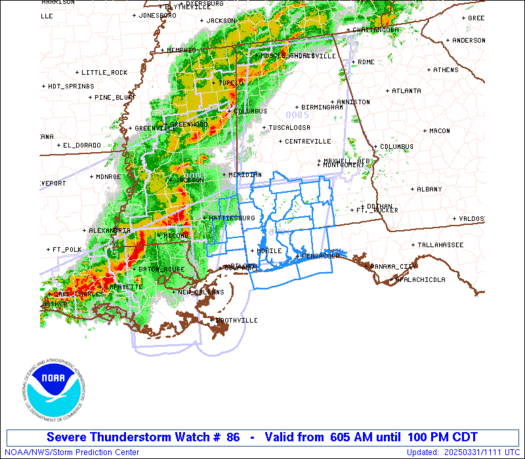
Bookmarks