


December marks the start of meteorological winter, even though record highs have been widespread. History has shown that Oklahoma weather during this time of year can fluctuate a lot. Fire Danger also goes up significantly as vegetation is now dormant. Severe weather, while not typical isn't completely rare this time of year. The severe weather images though will be removed for the winter to clear things up a bit in this post.
This initial post will contain information, images, and links that can be used at any time. Images posted later through the thread may or may not be accurate on the day you are viewing them (check the post comments). Information contained in this thread should not be used as an alternative to weather radios, media, or other means of getting weather warnings/advisories.
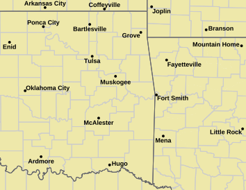
Current Conditions
Severe Weather Information
Norman Warning Area Map Tulsa County Warning Area Map Tornado Warning | Tornado Watch | Severe Thunderstorm Warning | Severe Thunderstorm Watch
Red Flag Warning | Fire Warning | Severe Weather Statement | Special Weather Statement
Hazardous Weather Outlook | Fire Weather Watch
Other Color Meanings: Web-Based Watch/Warning/Advisory Map Colors - NOAA's National Weather Service
Oklahoma Mesonet Current Conditions
Red - Air Temp, Green - Dewpoint, Barbs - Wind Speed/Direction, Gray - Gusts, Blue - Precip since Midnight
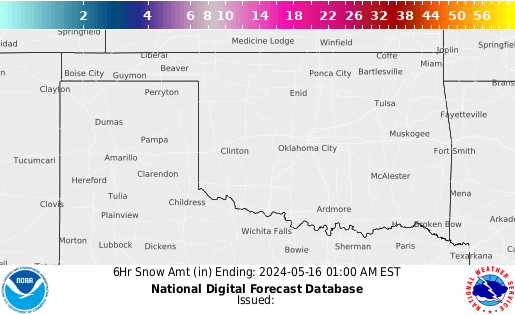
Snowfall Images
24 Hour Snowfall Totals
6 Hour Snowfall Forecasts
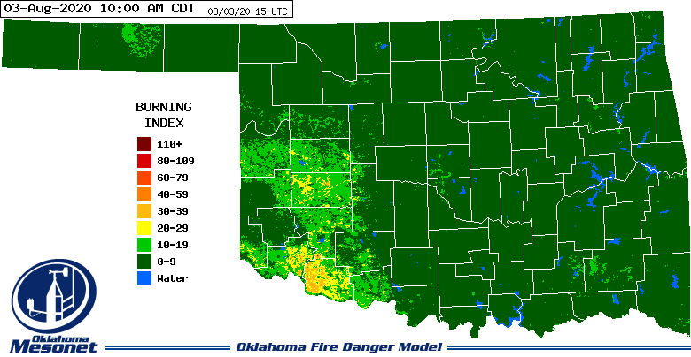
Fire Weather Images
6 Hr 12 Hr 18 Hr 24 Hr 30 Hr 36 Hr 42 Hr 48 Hr
Oklahoma Mesonet 24-inch Fractional Weather Index Image
Image will appear blank overnight.
Oklahoma Mesonet Relative Humidity Image
Enhanced Colors - Blues are higher/colder cloud tops, Reds are warmer normally clear skies.
Oklahoma Mesonet -Burn Index Image
Image will appear blank overnight.
Oklahoma Mesonet Consecutive Days with Less Than 0.25" of Rain Image
Enhanced Colors - Blues are higher/colder cloud tops, Reds are warmer normally clear skies.
SPC Fire Weather Outlooks
*Click any above graphic to view discussion.*
References
- COD Weather Analysis Page: COD Meteorology -- Surface and Upper Air Data
- NWS Norman Page: NWS
- Storm Prediction Center: Storm Prediction Center
- Oklahoma Mesonet: Mesonet | Home Page
- West Texas Mesonet: Texas Tech University : West Texas Mesonet
- Oklahoma Fire Weather: NWS Norman Fire Weather Forecasts
- Oklahoma Road Conditions: Road Conditions
- Severe Weather Values Reference Guide: The Southern Indiana Weather Spotter's Reference -or- SEVERE WEATHER INDICES PAGE
- TwisterData Model Page: TwisterData.com | Weather Data & Model Forecasts
- Earl Barker's Central US Model Page: Earl Barker's CENTRAL US Model Page
- NSSL WRF Model: NSSL Realtime WRF model Forecasts
- NSSL 4KM WRF Model Forecast Soundings: NSSL 4km WRF Forecast Soundings
- HRRR Rapid Refresh Model: HRRR Model Fields - Experimental
Tutorial: HOW TO VIEW DATA IN HRRR
Step 1) Go the main page: High-Resolution Rapid Refresh (HRRR)
Step 2) Click on 3km HRRR-CONUS hourly
Step 3) Under Domain select SC for South Central US
Step 4) Look at the time frames available. Usually if it isn't through Hour 06 yet, I'll just go up to Date and select the previous time.
Step 5) Depending on what you want to see you can click on the specific time or to loop all the times available you'll see a Check Mark under loop. You can click that to loop them all.
Oklahoma Mesonet Visible Satellite Image
Image will appear blank overnight.
Oklahoma Mesonet IR Satellite Image
Enhanced Colors - Blues are higher/colder cloud tops, Reds are warmer normally clear skies.


 Reply With Quote


Bookmarks