

It should loosen the opposite direction the blade turns I think.... or I may have that backwards

 Participating Member

It should loosen the opposite direction the blade turns I think.... or I may have that backwards
Thanks, amigo . . .
I guess I'll just have to call My LawnCare Expert.
I don't know if he is right...or left...
But for sure he ain't a-gonna leave to mud on the driveway. =)
Apology: Everybody talks about the weather. Or not.
Venture: Thank you for your forbearance and understanding.
(did i spell forbearance rite?)
And thanks a lot for bringing us that [dad-gumm-burned/blaimed] hailstorm a couple of weeks ago. =)
Participating Member
Rain is coming!!! Rain is coming!!!
Participating Member
This
Participating Member
Is it still June? Or is Venture sacking on creating a July thread?
VIP Member
If you look a few posts up, OKCisOK4me, then you'll see that venture had planned on adding July to the June thread since there wasn't enough of a change to warrant a new thread. I guess it just never happened.
Still corrupting young minds
Participating Member
Sorry. We're all guilty of not looking a few posts up from time to time, lol.
VIP Member
Oh yeah, it happens to all of usHowever, it's not like the weather has changed, anyway. July might as well be June at this point.
Still corrupting young minds
David
Yeah I put in a request to have one of the mods add July to the title since there wasn't much point in creating a new one. LOL
I'll put in another request and see if they can update it for me.
David
Good amount of dust being kicked up over Southern Norman by this thing.
SEVERE THUNDERSTORM WARNING
OKC027-087-142315-
/O.NEW.KOUN.SV.W.0401.120714T2252Z-120714T2315Z/
BULLETIN - IMMEDIATE BROADCAST REQUESTED
SEVERE THUNDERSTORM WARNING
NATIONAL WEATHER SERVICE NORMAN OK
552 PM CDT SAT JUL 14 2012
THE NATIONAL WEATHER SERVICE IN NORMAN HAS ISSUED A
* SEVERE THUNDERSTORM WARNING FOR...
SOUTHEASTERN CLEVELAND COUNTY IN CENTRAL OKLAHOMA...
EXTREME EAST CENTRAL MCCLAIN COUNTY IN CENTRAL OKLAHOMA...
* UNTIL 615 PM CDT
* AT 550 PM CDT...NATIONAL WEATHER SERVICE METEOROLOGISTS DETECTED
A SEVERE THUNDERSTORM CAPABLE OF PRODUCING DAMAGING WINDS IN
EXCESS OF 60 MPH. THIS STORM WAS LOCATED NEAR ETOWAH...MOVING
SOUTHWEST AT 20 MPH.
* LOCATIONS IMPACTED INCLUDE...
PURCELL...SLAUGHTERVILLE...LEXINGTON...ETOWAH AND LAKE THUNDERBIRD.
THIS INCLUDES INTERSTATE 35 BETWEEN MILE MARKERS 88 AND 98.
PRECAUTIONARY/PREPAREDNESS ACTIONS...
MOVE INSIDE A STURDY BUILDING UNTIL THE STORM HAS PASSED.
&&
LAT...LON 3493 9737 3512 9742 3528 9719 3511 9714
3503 9714
TIME...MOT...LOC 2250Z 54DEG 19KT 3510 9723
Participating Member
It keeps getting hotter at my house... was 96 and I was waiting for it to cool down before I mowed and now it's 99.
Down to 91 so I can mow
Participating Member
OK, its getting close to fall garden planting time. Some of my vegetables won’t survive extreme heat particularly when they are very young. When is this hot high pressure system going to move on?
I need to plant things in the next 10 days or so, or the production will be limited this fall.
David
We might get into a Northwest flow pattern by early August but right now I wouldn't bet on it. The ridge is firmly entrenched and no indication of it moving. At this point we very well could remain in this setup until the end of August or early September. Of course if we could El Nino going faster that could help bring the jetstream back south sooner.Originally Posted by ou48A

Participating Member
Thanks Venture
Last night Gary England said that we might see slightly cooler weather this next Thursday and Friday.
As far as fall gardening goes that’s probably going to be my best shot.
I ‘m sure glad I don’t depend on growing things in Oklahoma to make a living.
Participating Member
slightly cooler could be 100 *lol*
Participating Member
Current conditions at
Norman / Max Westheimer
106°F
Humidity32%
Wind Speed N 9 mph
Barometer 30.02 in
Dewpoint 70°F (21°C)
Visibility 10.00 mi
Heat Index116°F
Participating Member
NOAA says drought to possibly extend and remain virtually intact through October. Yikes.
http://climatecrocks.com/2012/07/20/...l-linger-noaa/
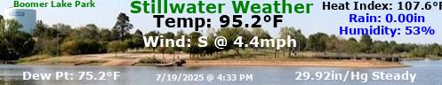
Norman is getting a lot of heat today Yesterday was the hottest day of the year in Stillwater with 106. If forecasted high of 110 works out it will be topped.
Participating Member
Sitting here sipping a large glass of ice tea with a ceiling fan on me and the thermoset set on 73 sure has me nostalgic for my old outdoor hard working days and for my football 2 days. not.....
It’s now 108 at Norman / Max Westheimer
Participating Member
Im beginning to really hate the phrase "heat dome".
Participating Member
Current conditions at Norman / Max Westheimer
Partly Cloudy 109°F…… Heat Index 117°F
David
Severe weather statement
national weather service norman ok
408 pm cdt fri jul 20 2012
okc069-099-123-202130-
/o.con.koun.sv.w.0405.000000t0000z-120720t2130z/
murray ok-pontotoc ok-johnston ok-
408 pm cdt fri jul 20 2012
...a severe thunderstorm warning remains in effect until 430 pm
cdt for northeastern murray...southwestern pontotoc and extreme
northwestern johnston counties...
At 407 pm cdt...national weather service meteorologists detected a
severe thunderstorm capable of producing damaging winds in excess
of 60 mph. This storm was located near fitzhugh...moving southwest
at 20 mph.
David
MESOSCALE DISCUSSION 1520
NWS STORM PREDICTION CENTER NORMAN OK
0345 PM CDT FRI JUL 20 2012
AREAS AFFECTED...SRN/WRN OK...NRN TX...ERN TX PANHANDLE
CONCERNING...SEVERE POTENTIAL...WATCH UNLIKELY
VALID 202045Z - 202315Z
PROBABILITY OF WATCH ISSUANCE...5 PERCENT
SUMMARY...A VERY ISOLATED SVR MICROBURST POTENTIAL WILL EXIST THIS
AFTERNOON...AND THE ISSUANCE OF A WW IS UNLIKELY.
DISCUSSION...OKLAHOMA MESONET OBSERVATIONS INDICATE THAT A SFC
HOT-THERMAL AXIS -- TEMPS FROM 105 TO 109 DEGREES -- ARCS FROM NW OK
THROUGH THE OKC METRO AREA AND FARTHER SE INTO SERN OK. A SFC TROUGH
ALIGNS WITH THERMAL AXIS...WITH A REMNANT/DIFFUSE STATIONARY FRONT
DRAPED NEARLY W-E JUST NORTH OF THE THERMAL AXIS. OVERLAPPING THE
SRN FRINGES OF THE HOTTEST SFC TEMPERATURES...A RIBBON OF ENHANCED
MID-LEVEL MOISTURE PER WATER VAPOR IMAGERY EXTENDS FROM THE ERN TX
PANHANDLE TROUGH SRN OK/NRN TX AND FARTHER EAST ACROSS SRN AR/NRN
LA...WITH 700-MB DEWPOINTS IN EXCESS OF 6C PER 12Z RAOBS. DEEP
BOUNDARY-LAYER CIRCULATIONS AMIDST THIS RELATIVE MAXIMUM IN MOISTURE
HAVE ALLOWED VERY ISOLATED STORMS TO DEVELOP. THIS DEVELOPMENT HAS
BEEN AIDED BY ASCENT ALONG THE TROUGH...AND PERHAPS BY A REMNANT
MID-LEVEL CIRCULATION NEAR THE INTERSECTION OF I-35 AND THE RED
RIVER WHICH HAS BECOME INCREASINGLY ILL-DEFINED THROUGH THE DAY.
WEAK FLOW THROUGH THE LOW/MID LEVELS PER AREA VWP DATA WILL FOSTER A
PULSE CONVECTIVE MODE AND DISORGANIZED CONVECTION...MOVING SLOWLY
SSWWD/SWWD. HOWEVER...VERY STEEP LOW-LEVEL LAPSE RATES OWING TO THE
HOT SFC TEMPERATURES -- SUPPORTING DCAPE WELL IN EXCESS OF
1000 J/KG -- WILL PROMOTE STRONG MICROBURSTS THROUGH THE AFTERNOON.
GIVEN THESE THERMODYNAMIC CONDITIONS...VERY ISOLATED INSTANCES OF
SVR WIND GUSTS CANNOT BE RULED OUT WITH THE STRONGEST STORMS.
..COHEN/HART.. 07/20/2012
Participating Member
power flickered here in central OKC.
David
Slight Risk of severe weather today for Central into Northeast Oklahoma.
...OK THROUGH MID MS VALLEY REGION...
OTHER STORMS WILL REDEVELOP AND INTENSIFY ALONG SWRN EXTENSION OF
FRONT AND PRE-FRONTAL OUTFLOW BOUNDARIES FROM THE MID MS VALLEY INTO
NRN PARTS OF THE SRN PLAINS. MOST OF THIS REGION WILL REMAIN SOUTH
OF THE STRONGER FLOW ALOFT ASSOCIATED WITH AMPLIFYING UPPER TROUGH.
HOWEVER...THE THERMODYNAMIC ENVIRONMENT WILL FAVOR A THREAT OF
ISOLATED DAMAGING WIND AND DOWNBURSTS WITH MULTICELL CONVECTION AS
LOW LEVEL LAPSE RATES STEEPEN ALONG THERMAL AXIS.
There are currently 1 users browsing this thread. (0 members and 1 guests)
 Posting Permissions

 Reply With Quote


Bookmarks