

its time to start the new weather post for March/April. This time of the year is Severe weather season so be safe when it happen.

 Participating Member

its time to start the new weather post for March/April. This time of the year is Severe weather season so be safe when it happen.
Last edited by Pete; 03-25-2012 at 08:53 AM.
Participating Member
i say we will get some severe weather for March and April but hopefully no tornadoes
Participating Member
http://www.srh.noaa.gov/images/fxc/o...mage_full3.jpg
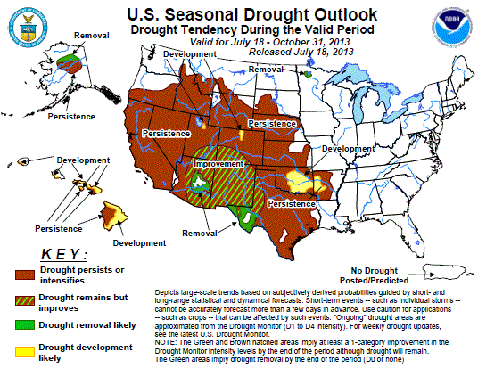
glad that part of the state is drought free
Participating Member
Is it suppose to be "in like a lion out like a lamb" or the other way around this storm season?
David
This thread is used to discussion upcoming/ongoing severe weather events through the month of March. We are coming off of a very mild and somewhat dry La Nina Winter. How this will impact our severe weather season isn't in stone yet, but we have had significant tornado seasons as well as very quiet seasons. This initial post will contain information, images, and links that can be used at any time. Images posted later through the thread may or may not be accurate on the day you are viewing them (check the post comments). Information contained in this thread should not be used as an alternative to weather radios, media, or other means of getting weather warnings/advisories.
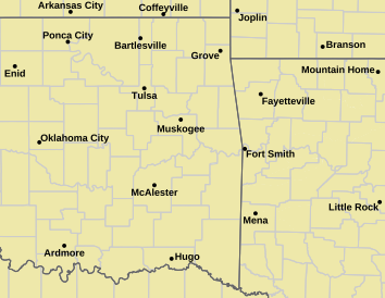
_________Norman Warning Area Map __________________ Tulsa County Warning Area Map____

Tornado Warning | Tornado Watch | Severe Thunderstorm Warning | Severe Thunderstorm Watch | Blizzard Warning | Red Flag Warning | Fire Warning | Winter Storm Warning | Winter Storm Watch | Freezing Rain Advisory | Heavy Snow Warning | Winter Weather Advisory | Severe Weather Statement | Special Weather Statement | Hazardous Weather Outlook | Fire Weather Watch
Other Color Meanings: http://www.weather.gov/wwamap-prd/faq.php
NWS NEXRAD Radar Loop - Twin Lakes/Oklahoma City/Norman
SPC Convection (Severe Weather) Outlooks
________ Day 1 ________________ Day 2 _________________ Day 3 ___________ Days 4 through 8 ___


*Click any above graphic to view discussion.*
SPC Fire Weather Outlooks
________ Day 1 ________________ Day 2 ______________ Days 3 to 8 _____


*Click any above graphic to view discussion.*
Oklahoma Mesonet Visible Satellite Image (will appear blank overnight)
Oklahoma Mesonet IR Satellite Image (will appear blank overnight)
Oklahoma Mesonet Water Vapor Satellite Image (will appear blank overnight)
Oklahoma Mesonet Current Conditions
SPC Severe Weather Reports (Today and Yesterday)
________ Today _____________ Yesterday _____
Useful Links
COD Weather Analysis Page: http://weather.cod.edu/analysis/
NWS Norman Page: http://www.srh.noaa.gov/oun/
Storm Prediction Center: http://www.spc.noaa.gov/
Oklahoma Mesonet: http://www.mesonet.org/
West Texas Mesonet: http://www.mesonet.ttu.edu/
Oklahoma Fire Weather: http://www.srh.noaa.gov/oun/?n=fireweather
Oklahoma Road Conditions: http://www.dps.state.ok.us/cgi-bin/weathermap.cgi
Severe Weather Values Reference Guide: http://weatherspotter.net/index11.php -or- http://www.theweatherprediction.com/severe/indices/
TwisterData Model Page: http://www.twisterdata.com/
Earl Barker's Central US Model Page: http://128.121.193.153/central_models.htm
NSSL WRF Model: http://www.nssl.noaa.gov/wrf/
NSSL 4KM WRF Model Forecast Soundings: http://www.nssl.noaa.gov/wrf/sdg/
HRRR Rapid Refresh Model: http://rapidrefresh.noaa.gov/hrrrconus/[/QUOTE]
David
...
David
Things are a little disorganized for the start of this thread since 2 others got merged in. So my apologies for things being out of order.
Participating Member
Hey venture any thoughts about El niño in the 5-10 month range?
Participating Member

Latest Seasonal Assessment - The drought outlook for February 16 – May 31, 2012 is based on short-, medium-, and long-range forecasts, climate anomalies associated with a weakening La Niña, initial conditions, and climatology. Since the release of the previous drought outlook on February 2, 2012, significant precipitation has fallen across the Pacific Northwest, portions of the Rockies, the southern Plains, the lower Mississippi Valley, and the central Gulf Coast region. The Climate Prediction Center (CPC) predicts a tilt in the odds for above-normal temperatures for most areas east of the Continental Divide in March, and enhanced odds for below-normal temperatures across the West Coast states and the southern two-thirds of Alaska. This general pattern is also anticipated for the March-May 2012 season, though with increased odds for above-normal temperatures across the Southwest. For precipitation, there is a tilt in the odds for wetter-than-normal conditions across the Pacific Northwest and the southern Alaska Panhandle in March, and for a fairly large area encompassing the Great Lakes, the Ohio Valley, and eastern portions of the upper and middle Mississippi Valley. In general, these same regions are expected to receive above-median precipitation during the March-May 2012 period, though with reduced coverage. Unfortunately, most of the anticipated precipitation is forecast to fall just east and southeast of where it is needed most in the upper Midwest. Most indicators support a westward expansion of dryness across the Dakotas. The CPC precipitation forecast for March also calls for elevated odds of below-median precipitation across most of California, the Southwest, and the Gulf Coast and southern Atlantic Coast regions. For the March-May 2012 forecast period, the same general areas are expected to receive below-median precipitation, though with the addition of south-central and southeastern Alaska. However, for Texas and the Gulf Coast region, the upcoming 5-7 days is likely to feature heavy to very heavy precipitation (2”-5”), which should provide at least temporary, short-term drought relief, but may have little impact on longer-term hydrologic deficits. In Hawaii, improvement is forecast for Oahu, with some improvement considered most likely for the leeward slopes of Maui, Molokai , Lanai, and the Big Island.
Participating Member
Looks like another spring and summer having to only mow once a month
David
Significant fire danger tomorrow for most of Oklahoma.
URGENT - FIRE WEATHER MESSAGE
NATIONAL WEATHER SERVICE NORMAN OK
220 PM CST WED FEB 29 2012
OKZ006>008-011>031-033>039-044-TXZ083>089-011100-
/O.CON.KOUN.FW.A.0005.120301T1800Z-120302T0000Z/
ALFALFA-GRANT-KAY-MAJOR-GARFIELD-NOBLE-ROGER MILLS-DEWEY-CUSTER-
BLAINE-KINGFISHER-LOGAN-PAYNE-BECKHAM-WA****A-CADDO-CANADIAN-
OKLAHOMA-LINCOLN-GRADY-MCCLAIN-CLEVELAND-POTTAWATOMIE-SEMINOLE-
HARMON-GREER-KIOWA-JACKSON-TILLMAN-COMANCHE-STEPHENS-COTTON-
HARDEMAN-FOARD-WILBARGER-WICHITA-KNOX-BAYLOR-ARCHER-
220 PM CST WED FEB 29 2012
...FIRE WEATHER WATCH REMAINS IN EFFECT THURSDAY AFTERNOON FOR
VERY WARM... WINDY AND DRY CONDITIONS FOR PARTS OF NORTHERN...
CENTRAL... AND WESTERN OKLAHOMA... AND WESTERN NORTH TEXAS...
* WIND...GUSTY SOUTHWEST WIND 15 TO 25 MPH WITH GUSTS NEAR 30
MPH...ESPECIALLY CENTRAL AND NORTH CENTRAL OKLAHOMA.
* HUMIDITY...AFTERNOON HUMIDITY WILL FALL BELOW 20 PERCENT
ACROSS AT LEAST WESTERN OKLAHOMA AND WESTERN NORTH TEXAS
* TEMPERATURE...WILL WARM INTO THE 70S AND LOWER 80S.
* IMPACTS...ANY FIRES THAT DEVELOP WILL LIKELY SPREAD RAPIDLY.
OUTDOOR BURNING IS NOT RECOMMENDED.
PRECAUTIONARY/PREPAREDNESS ACTIONS...
MONITOR WEATHER FORECASTS AND INFORMATION.
David
So tomorrow will have a significant risk of a severe weather outbreak east of Oklahoma, but what do we have to look forward to. This is based off the 12Z GFS.
Thursday 8th - Chance of showers/storms over much of the state. Precip amounts generally less than an inch. Low risk of severe weather.
Friday 9th - Chance of storms, some severe over much of OK.
Saturday 10th - Chance of storms over Western OK, some severe.
Sunday 11th - Storms, some with heavy rain. Severe chances mainly eastern half.
Tuesday 13th - Slight chance of storms, some severe.
Wednesday 14th - Slight chance of storms, severe probable.
Thursday 15th - Severe storms.
Then appears to be a cool down after the 15th with another strong storm system moving on shore in the Pac Northwest. Wouldn't be shocked if the following weekend we see more unsettled weather. Appears spring is here and ready to roll.
Participating Member
Looks like the drought prediction a couple posts up isn't off to a great start ...Bring on the precip now that we are in the 60's and 70's
HYDROLOGIC OUTLOOK
Message summary: ...spring flood potential outlook for western and central oklahoma and western north texas...
The potential for flood conditions in western/central oklahoma and western north texas will be near normal this spring. Flooding usually occurs in response to specific precipitation events. There are currently no indications of extreme hydrologic conditions to alter the flood potential of the area. So far this water year /1 october 2011 through 29 february 2012/...areas along the i-44 corridor in central and southwestern oklahoma...as well as western north texas...have received below normal rainfall. However portions of western...northern...and southern oklahoma have received above normal precipitation for the water year. For february...ellis..woodward...woods...and eastern harper counties have seen 300 to 600 percent of normal rainfall. The rest of north central oklahoma received monthly precipitation amounts of 125 to 300 percent of normal. The remainder of the area is below to well below normal...with most locations receiving only 25 to 75 percent of the normal rainfall over the past month. The climate prediction center /cpc/ outlook for spring 2012 /march-april-may/ indicates equal chances for above...near...and below normal rainfall and an enhanced chance for above normal temperatures across western/central oklahoma and western north texas. Soil moisture across most of oklahoma and in western north texas is currently reflecting near normal conditions for this time of year...with moisture values in the 30th to 70th percentiles. However...soil moisture is well below normal in extreme western oklahoma...with values in the 10th to 30th percentiles. According to the u.s. Geological survey...streams and rivers are running at normal to below normal levels across western/central oklahoma and western north texas. There is currently no ongoing flooding. Reservoirs in parts of northern oklahoma have near 100 percent of their flood control storage available with full conservation pools according to the u.s. Army corps of engineers. However...reservoirs in parts of western and southern oklahoma...as well as western north texas...are utilizing only 20 to 75 percent of their conservation pools. The u.s. Drought monitor for february 28th indicates that moderate to extreme drought conditions exist generally along and northwest of a line from duncan to ada to holdenville in western and central oklahoma. Moderate to exceptional drought conditions are occurring in western north texas. The u.s. Seasonal drought outlook from march 1 indicates that drought conditions are likely to persist in this area through the spring months.
Participating Member
Bunty, This post is just to highlight the most important part of that for the OKC area.Originally Posted by Bunty

David
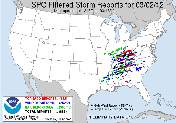
Still early on how many tornadoes there actually were, but the SPC filtered reports (which tries to consolidate similar reports for the same tornado) has it at 80 total. So far 32 confirmed fatalities. Not a good start to the season.
Participating Member
Don't wish them on anyone and call me selfish but fine with these popping up to the east of us this spring
I'm not fine with it, since I fear it may mean things will get real rough here by April or May. I don't like the stress and worry about being under a tornado warning.
David
The SE US is normally under the gun Feb-Apr...we start to pick up in April. The only odd thing was these were a bit further North than they should be this time of year.
Participating Member
Its not spring yet though, at least not officially. We still have a long way to go until severe weather season ends.
Participating Member
My thoughts and prayers to those affected by the storms.
David
Longer range outlook for Central/Western OK according to the 12Z GFS...haven't done one of these in awhile.
Dry through Tuesday Mar 8.
Weds Mar 7 - Increasing precip through the day. Mostly light rain/drizzle Central and more heavier amounts West. Could have a few storms around, severe risk is relatively low.
Thur Mar 8 - Moderate/Heavy rain statewide. Could see some areas with over 1". Strong cold front will be moving through, temps ahead of it will be in the 60s/70s and in the 30s behind. Right now coldest air should be I-35 and west. 12Z GFS is showing a chance for a change over to snow across Western OK. The highest amounts are indicated in NW OK where over 12" are predicted, but take that with a high level of uncertainty please. Amounts will go down to around an inch or less in SW OK.
Fri Mar 9 - Wrap around moisture will move through the state on Friday. Temps will be in the 30s/40s, so some additional snow accumulation or rain/snow mix could be possible. Could see a dusting across Central OK and up to an inch East.
Sat Mar 10 - Additional precip possible over the East, but otherwise dry. Temps in the 40s.
Sun Mar 11 - Dry. Temps 30s North, 40s elsewhere.
Mon Mar 12 - Dry. Temps 50s or lower where snow pack may exist.
Tue Mar 13 - Dry. Temps 50s/60s.
Wed Mar 14 - Dry with a slight chance of a storm out West. Temps 60s/70s.
Thur Mar 15 - Slight chance of storms West, some severe possible. Temps 60s/70s.
Fri Mar 16 - Slight chance of storms West, some severe possible. Temps 60s/70s.
Sat Mar 17 - Chance of storms Northwest half of OK, slight risk of severe storms mainly NW and West Central OK. Temps 60s/70s.
Sun Mar 18 - Showers/Storms. Some severe early but evolve to a general area of convection through the day. Temps 60s/70s with cooler temps where precip is more prolonged.
Mon Mar 19 - Storms/Storms. Some severe as instability will increase through the day. Temps 60s.
No real indication of any major pockets of cold air redeveloping for a late month cool down. Things should stay pretty seasonable is appears. As always this time of year, any chance there is a chance of storms there is a risk of severe weather. As it stands now the 17th has the higher probability of severe weather, but it is still 2 weeks out. Risk for the upcoming week could be higher than indicated, but models aren't really in much agreement right now. Either way, take it all with a grain of salt and things will get clearer as we get closer.
David
Meteorological Spring starts March 1st, so it depends who you talk to. :-)
David
Rough few days with Fire Weather coming up.
David
00Z GFS is keeping with the accumulating snow chances next week. Also severe weather risks.
There are currently 1 users browsing this thread. (0 members and 1 guests)
 Posting Permissions

 Reply With Quote


Bookmarks