Widgets Magazine
Page 1 of 10 123456 ... LastLast
Results 1 to 25 of 250

Thread: Oklahoma Severe Weather Discussion - September/October 2011

  1. Default Oklahoma Severe Weather Discussion - September/October 2011

    This thread will be used to discussion upcoming/ongoing severe weather events through the months of September and October. As we transition into Fall, Oklahoma typically experiences a secondary severe weather/tornado season. This initial post will contain information, images, and links that can be used at any time. Images posted later through the thread may or may not be accurate on the day you are viewing them (check the post comments). Information contained in this thread should not be used as an alternative to weather radios, media, or other means of getting weather warnings/advisories.


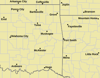
    _________Norman Warning Area Map __________________ Tulsa County Warning Area Map____

    Tornado Warning | Tornado Watch | Severe Thunderstorm Warning | Severe Thunderstorm Watch | Blizzard Warning | Red Flag Warning | Fire Warning | Winter Storm Warning | Winter Storm Watch | Freezing Rain Advisory | Heavy Snow Warning | Winter Weather Advisory | Severe Weather Statement | Special Weather Statement | Hazardous Weather Outlook | Fire Weather Watch
    Other Color Meanings: http://www.weather.gov/wwamap-prd/faq.php

    SPC Convection (Severe Weather) Outlooks

    ________ Day 1 ________________ Day 2 _________________ Day 3 ___________ Days 4 through 8 ___


    *Click any above graphic to view discussion.*

    SPC Fire Weather Outlooks

    ________ Day 1 ________________ Day 2 ______________ Days 3 to 8 _____


    *Click any above graphic to view discussion.*

    CoD NEXRAD Radar Mosaic


    CoD Visible Satellite Image (will appear blank overnight)


    Oklahoma Mesonet Current Conditions


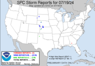
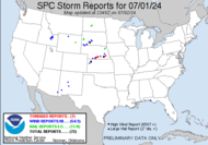
    SPC Severe Weather Reports (Today and Yesterday)
    ________ Today _____________ Yesterday _____


    Useful Links
    COD Weather Analysis Page: http://weather.cod.edu/analysis/
    NWS Norman Page: http://www.srh.noaa.gov/oun/
    Storm Prediction Center: http://www.spc.noaa.gov/
    Oklahoma Mesonet: http://www.mesonet.org/
    West Texas Mesonet: http://www.mesonet.ttu.edu/
    Oklahoma Fire Weather: http://www.srh.noaa.gov/oun/?n=fireweather
    Oklahoma Road Conditions: http://www.dps.state.ok.us/cgi-bin/weathermap.cgi
    Severe Weather Values Reference Guide: http://weatherspotter.net/index11.php -or- http://www.theweatherprediction.com/severe/indices/
    TwisterData Model Page: http://www.twisterdata.com/
    Earl Barker's Central US Model Page: http://128.121.193.153/central_models.htm
    NSSL WRF Model: http://www.nssl.noaa.gov/wrf/
    NSSL 4KM WRF Model Forecast Soundings: http://www.nssl.noaa.gov/wrf/sdg/

  2. Default Re: Oklahoma Severe Weather Discussion - September/October 2011

    Initial outlook taking us through the 21st of the month...

    Late Wednesday into Thursday - Chance of rain/storms West and Southwest OK.
    Sunday 11th - Chance of showers NE.
    Wednesday 14th - Chance of rain/storms NW half of Oklahoma.
    Thursday 15th - Chance of rain/storms Western OK.
    Friday 16th - Slight chance of rain, Northern & Western OK.

    Instability looks to start increasing as we go further out in the month, so storm chances will increase instead of just rain. No major severe weather producers showing up just yet.

  3. Default Re: Oklahoma Severe Weather Discussion - September/October 2011

    Thanks, Venture!

    I'm going to call it that we will see no tornado in Oklahoma...at least not within the metro area. It will probably be the east, east, east, and more of the eastern half. Its all about the east this year. LOL

  4. #4

    Default Re: Oklahoma Severe Weather Discussion - September/October 2011

    Any rain is welcome but it looks like it will be dry for at least the next week over most of the state. There is always the potential that tropical moisture could play a role in the coming weeks. Hoping for more of an active pattern as we transition to fall.

  5. #5

    Default Re: Oklahoma Severe Weather Discussion - September/October 2011

    If you want a radar map that isn't a mess of ground clutter, then go to this interactive one here: http://www.intellicast.com/Local/WxMapFull.aspx

  6. Default Re: Oklahoma Severe Weather Discussion - September/October 2011

    Bunty, don't think it can be linked to appear directly on here. Nothing wrong with the radar images that Venture posted up above. Most of us know what ground clutter is and can pinpoint the difference between that and storm cells. What I'm saying here, Bunty, is that Venture is one of very few heroes to me and that I look up to him (don't think he realize that).

  7. Default Re: Oklahoma Severe Weather Discussion - September/October 2011

    Quote Originally Posted by Bunty View Post
    If you want a radar map that isn't a mess of ground clutter, then go to this interactive one here: http://www.intellicast.com/Local/WxMapFull.aspx
    There are pluses and minuses to a map like that. The map is definitely cleaner looking, but you don't get near the accurate detail of what is going on. A map like that typically has any returns under 20 dbz filtered out. So this is going to remove any ability to see features like fronts and outflow boundaries. Of course not everyone wants the higher level of detail, but for the sake of these threads I always will go with a more detail image.

  8. #8

    Default Re: Oklahoma Severe Weather Discussion - September/October 2011

    To me, the ground clutter can cover up so much you get ZERO detail. I'll take the intellicast radar map any time over this mess of a map: http://stillwaterweather.com/ridge.html Of course, I'm simply one of those who goes for less detail. Of course, if I want I can go to more detailed radar maps.

  9. #9

    Default Re: Oklahoma Severe Weather Discussion - September/October 2011

    Quote Originally Posted by Thunder View Post
    Bunty, don't think it can be linked to appear directly on here. Nothing wrong with the radar images that Venture posted up above. Most of us know what ground clutter is and can pinpoint the difference between that and storm cells. What I'm saying here, Bunty, is that Venture is one of very few heroes to me and that I look up to him (don't think he realize that).
    So I wasn't trying to be critical or negative of Venture's fine contributions, just pointing people to a prettier radar map to look at. Besides, not all of us are highly expert about interpreting various weather radar images.

  10. Default Re: Oklahoma Severe Weather Discussion - September/October 2011

    Potential seems to be going up for some well needed rain. Severe weather risk looks low to absent almost every day. The "Low to Near Slight" days are ones with a bit more instability, but things shouldn't reach severe limits except in a rare occasion. Temps look very manageable, but of course that part of the forecast could be swayed a lot by any occurring precip or lack thereof.

    Today 10th - Chance mostly Northeast OK. Mild 70s to 80s. Severe Risk: Very low.
    Sunday 11th - Mostly dry. 70s to 80s. Severe Risk: None.
    Monday 12th - Dry. 80s to low 90s. Severe Risk: None.
    Tues 13th - Slight chance Northern & Western OK. Upper 70s north, mid 90s southwest. Severe Risk: Very low.
    Weds 14th - Light to moderate rain Northern OK, chance SW. 70s north, near 90 south. Severe Risk: Low.
    Thurs 15th - Light to moderate rain statewide. Upper 50s north to upper 70s south. Severe Risk: Low to near Slight.
    Friday 16th - Light rain east, slight chance elsewhere. 60s and 70s. Severe Risk: Very low.
    Saturday 17th - Chance statewide. 70s and 80s. Severe Risk: Low to near Slight.
    Sunday 18th - Chance for widespread moderate rain statewide. 70s to near 80 south. Severe Risk: Low to near Slight.
    Monday 19th - Slight chance Southern/Southeast OK. 70s north, 80s south. Severe Risk: Very low.
    Tuesday 20th - Dry. 70s and 80s. Severe Risk: None.
    Wednesday 21st - Dry. 70s and 80s. Severe Risk: None.
    Thursday 22nd - Dry. 60s Northeast to near 80 southwest. Severe Risk: None.
    Friday 23rd - Dry. Mid 60s east, near 80 west. Severe Risk: None.
    Saturday 24th - Dry. Mid 60s east, near 80 west. Severe Risk: None.
    Sunday 25th - Dry. 70s and 80s. Severe Risk: None.

  11. #11

    Default Re: Oklahoma Severe Weather Discussion - September/October 2011

    Imagine that. It might rain when the fair comes to town. <VBG>

  12. Default Re: Oklahoma Severe Weather Discussion - September/October 2011

    Quote Originally Posted by kevinpate View Post
    Imagine that. It might rain when the fair comes to town. <VBG>
    Shhh. Don't let it know that.

    Even though it is nice that it is usually a guarantee to rain during the fair. LOL

  13. Default Re: Oklahoma Severe Weather Discussion - September/October 2011

    It will always rain a lot during the Great State Fair of Oklahoma.

  14. Default Re: Oklahoma Severe Weather Discussion - September/October 2011

    Still look to be on tap for rain started this week. Chances extend through early next week. Last day of 100+...hopefully for the year.

    Side note, looks like NWS Norman has joined the other offices already doing this and allowing people to take the spotter training online.

    https://www.meted.ucar.edu/training_course.php?id=23

    It will probably take a couple hours to complete, but it is a great (and free) tool to expand understanding of weather.

  15. #15

    Default Re: Oklahoma Severe Weather Discussion - September/October 2011

    Quote Originally Posted by Bunty View Post
    To me, the ground clutter can cover up so much you get ZERO detail. I'll take the intellicast radar map any time over this mess of a map: http://stillwaterweather.com/ridge.html Of course, I'm simply one of those who goes for less detail. Of course, if I want I can go to more detailed radar maps.
    It's probably a matter of training your eyes to process through the clutter. Takes time.

  16. #16

    Default Re: Oklahoma Severe Weather Discussion - September/October 2011

    The 100s came back Monday. Some people thought or hoped they would never come back for the rest of the year. I wonder if they will return again after this soon upcoming cool spell? As long as September days go on with all time record highs in the 100s in the record books, I wouldn't bet against it.

  17. #17

    Default Re: Oklahoma Severe Weather Discussion - September/October 2011

    Here's a map of the expected 5 day precipitation totals expected in the country. Looks like fairly attractive amounts of rain are in store for most of Oklahoma at least compared to what little we have been generally getting all summer long. It looks like a dark spot between Stillwater and Cushing may get 1.6" for some of the heaviest. A somewhat larger spot in southwestern Oklahoma will also get 1.6". The western tip of the panhandle may get a good amount. http://www.hpc.ncep.noaa.gov/qpf/p120i00.gif

  18. #18

    Default Re: Oklahoma Severe Weather Discussion - September/October 2011

    Quote Originally Posted by HewenttoJared View Post
    It's probably a matter of training your eyes to process through the clutter. Takes time.
    Anomalous propagation can be fun.

  19. Default Re: Oklahoma Severe Weather Discussion - September/October 2011

    Hi Maynard, what do you think of the cooler weather? Ready for a Blizzard?

  20. #20

    Default Re: Oklahoma Severe Weather Discussion - September/October 2011

    Quote Originally Posted by Thunder View Post
    Hi Maynard, what do you think of the cooler weather? Ready for a Blizzard?

  21. Default Re: Oklahoma Severe Weather Discussion - September/October 2011

    I see you are quite excited. We should have a thread where all members post their best pictures of snowmen, snowwomen, and snowanimal. :-)

  22. #22

    Default Re: Oklahoma Severe Weather Discussion - September/October 2011

    Yeah, it's about that time of year when we switch from global warming to global cooling.

  23. Default Re: Oklahoma Severe Weather Discussion - September/October 2011

    OUN's afternoon discussion...


    DISCUSSION...
    HIGH PRESSURE...CENTERED OVER THE UPPER MIDWEST...WILL CONTINUE TO
    PUSH COOL AND DRY AIR INTO OKLAHOMA AND NORTH TEXAS. AT THE SAME
    TIME...MOIST AIR AT MID-LEVELS WILL BE FORCED OVER THIS COOL AIR
    MASS. THE RESULTING LIFT WILL BRING WIDESPREAD RAIN AND A FEW
    THUNDERSTORMS TO MOST...IF NOT ALL...OF OUR FORECAST AREA OVER
    THE NEXT 24 TO 36 HOURS. HOWEVER...IT APPEARS THAT THE QUANTITY
    OF RAINFALL WILL BE RELATIVELY LIGHT IN MOST LOCATIONS.

    THE COOL...DRY LOW-LEVEL AIR...COMBINED WITH OCCASIONAL
    RAIN...WILL HOLD TEMPERATURES PERHAPS 5 TO 10 DEGREES ABOVE THE
    WET-BULB VALUES. THIS MEANS DAYTIME TEMPERATURES TOMORROW ARE
    LIKELY TO REMAIN IN THE 50S AND 60S OVER MOST OF OUR AREA...EXCEPT
    FOR A FEW 70S IN THE SOUTH. IF THERE IS MORE RAIN THAN CURRENTLY
    ANTICIPATED...TEMPERATURES MAY STAY EVEN LOWER. THE NAM CONTINUES
    TO SHOW LATE AFTERNOON TEMPERATURES IN THE UPPER 40S IN NORTHWEST
    OKLAHOMA. THIS...OF COURSE...IS IMPROBABLE...BUT NOT IMPOSSIBLE.


    AFTER TOMORROW...RAIN CHANCES BECOME MUCH MORE HIT-AND-MISS. LOW-
    LEVEL FLOW TURNS SOUTHERLY...AND MID-LEVEL FLOW WILL BE MAINLY
    ZONAL WITH UNFORECASTABLE SMALL WAVES RIPPLING THROUGH THE FLOW.
    THIS MEANS LOW POPS FOR MOST OF THE REST OF THE FORECAST
    PERIOD...AND A SLOW WARMING TREND INTO EARLY NEXT WEEK.

  24. Default Re: Oklahoma Severe Weather Discussion - September/October 2011

    Has anyone else noticed that it seems, at least in the last few years, that there is no gradual switch from one season to the next, but instead it's like someone flips the switch and BAM! It's fall? BAM! It's winter?

    I am not complaining in any way about cooler temperatures. The window unit in my classroom caused the electrical strip to get so hot there for a few days it would shut itself off around 2pm, leaving me with what little air would escape the vents in the ceiling from the "chillers" outside. I much prefer these days where I never even have to turn that noisy thing on! Bring on fall!
    Still corrupting young minds

  25. #25

    Default Re: Oklahoma Severe Weather Discussion - September/October 2011

    Quote Originally Posted by venture79 View Post
    OUN's afternoon discussion...


    DISCUSSION...
    HIGH PRESSURE...CENTERED OVER THE UPPER MIDWEST...WILL CONTINUE TO
    PUSH COOL AND DRY AIR INTO OKLAHOMA AND NORTH TEXAS. AT THE SAME
    TIME...MOIST AIR AT MID-LEVELS WILL BE FORCED OVER THIS COOL AIR
    MASS. THE RESULTING LIFT WILL BRING WIDESPREAD RAIN AND A FEW
    THUNDERSTORMS TO MOST...IF NOT ALL...OF OUR FORECAST AREA OVER
    THE NEXT 24 TO 36 HOURS. HOWEVER...IT APPEARS THAT THE QUANTITY
    OF RAINFALL WILL BE RELATIVELY LIGHT IN MOST LOCATIONS.

    THE COOL...DRY LOW-LEVEL AIR...COMBINED WITH OCCASIONAL
    RAIN...WILL HOLD TEMPERATURES PERHAPS 5 TO 10 DEGREES ABOVE THE
    WET-BULB VALUES. THIS MEANS DAYTIME TEMPERATURES TOMORROW ARE
    LIKELY TO REMAIN IN THE 50S AND 60S OVER MOST OF OUR AREA...EXCEPT
    FOR A FEW 70S IN THE SOUTH. IF THERE IS MORE RAIN THAN CURRENTLY
    ANTICIPATED...TEMPERATURES MAY STAY EVEN LOWER. THE NAM CONTINUES
    TO SHOW LATE AFTERNOON TEMPERATURES IN THE UPPER 40S IN NORTHWEST
    OKLAHOMA. THIS...OF COURSE...IS IMPROBABLE...BUT NOT IMPOSSIBLE.


    AFTER TOMORROW...RAIN CHANCES BECOME MUCH MORE HIT-AND-MISS. LOW-
    LEVEL FLOW TURNS SOUTHERLY...AND MID-LEVEL FLOW WILL BE MAINLY
    ZONAL WITH UNFORECASTABLE SMALL WAVES RIPPLING THROUGH THE FLOW.
    THIS MEANS LOW POPS FOR MOST OF THE REST OF THE FORECAST
    PERIOD...AND A SLOW WARMING TREND INTO EARLY NEXT WEEK.
    Just on the weather last night they said heavy rainfall was possible. I guess this was incorrect and now were supposed to be getting light rain?

Thread Information

Users Browsing this Thread

There are currently 1 users browsing this thread. (0 members and 1 guests)

Similar Threads

  1. Oklahoma Severe Weather Discussion - July & August 2011
    By venture in forum Weather & Geosciences
    Replies: 265
    Last Post: 09-06-2011, 07:29 PM
  2. Oklahoma Severe Weather Discussion - June 2011
    By venture in forum Weather & Geosciences
    Replies: 155
    Last Post: 06-29-2011, 04:47 AM
  3. Oklahoma Severe Weather Discussion - May 2011
    By venture in forum Weather & Geosciences
    Replies: 377
    Last Post: 05-31-2011, 11:33 PM
  4. Oklahoma Severe Weather Discussion - April 2011
    By venture in forum Weather & Geosciences
    Replies: 286
    Last Post: 04-29-2011, 11:28 PM
  5. Oklahoma Severe Weather Discussion - March 2011
    By venture in forum Weather & Geosciences
    Replies: 94
    Last Post: 04-03-2011, 10:39 AM

Bookmarks

Posting Permissions

  • You may not post new threads
  • You may not post replies
  • You may not post attachments
  • You may not edit your posts
  •  
Single Sign On provided by vBSSO