


If I was, I would have, instead, moved to Colorado Springs years ago. Typical for that city in the middle of summer is to have highs in the 80s and lows in the 50s.Originally Posted by Thunder


If I was, I would have, instead, moved to Colorado Springs years ago. Typical for that city in the middle of summer is to have highs in the 80s and lows in the 50s.
 Participating Member

CH 4 DP says we have about another 7 or 8 days of 108 to 110+ then it might cool off to the upper 90’s
Participating Member
Well, that'll still get us to 50+ days this year...
Colorado Springs and Denver can get temps. in the 90's often in the summer, but the humidity is low and afternoon thunderstorms and clouds that develop over the Front Range move east and cool it off almost every day.
David
Yawn...
AREA FORECAST DISCUSSION
NATIONAL WEATHER SERVICE NORMAN OK
257 PM CDT THU AUG 4 2011
.DISCUSSION...
...EXCESSIVE HEAT WARNING THROUGH SUNDAY...
UNFORTUNATELY... THE UNUSUAL HAS BECOME THE USUAL WITH REGARDS TO
THE INTENSE HEAT THIS SUMMER OVER THE CWA. TEMPERATURES NEAR OR
EXCEEDING RECORD HIGH TEMPERATURES ARE EXPECTED THROUGH THE WEEKEND
INTO EARLY NEXT WEEK. MODELS STILL SHOWING A PATTERN SHIFT BEGINNING
AROUND TUESDAY AND CONTINUING THROUGH THE REST OF THE WEEK.
THE OUTFLOW/FRONTAL BOUNDARY WILL PLAY A PRETTY BIG ROLE IN THE
WEATHER THROUGH THE WEEKEND. THE STALLED BOUNDARY... WITH CLOUD
COVER FROM OVERNIGHT CONVECTION... SLOWED THE WARM UP OVER THE
NORTHERN HALF OF OKLAHOMA. HOWEVER... TEMPERATURES HAD ONCE AGAIN
EXCEEDED 100 DEGREES OVER ALL BUT OUR NORTHERN BORDER COUNTIES.
EXPECT ISOLATED THUNDERSTORMS TO DEVELOP NEAR THIS BOUNDARY LATE
THIS AFTERNOON INTO THIS EVENING. ADDITIONAL THUNDERSTORMS ARE
POSSIBLE OVER THE HIGHER TERRAIN... WHICH MAY THEN IN TURN MOVE INTO
NORTHERN OKLAHOMA OVERNIGHT.
THE BOUNDARY DOES LIFT NORTH TOMORROW INTO SATURDAY... BUT WILL
PROBABLY WAFFLE BACK AND FORTH INTO OKLAHOMA FRIDAY NIGHT AND
SATURDAY. THE PLACEMENT OF THE BOUNDARY AND ASSOCIATED CLOUD COVER
TO THE NORTH WILL DETERMINE THOSE THAT GET HOT... AND THOSE THAT GET
REALLY HOT. THE FORECAST TEMPERATURES FOR OKLAHOMA CITY COULD END
UP BEING A FEW DEGREES TOO WARM TOMORROW AND SATURDAY IF THE
BOUNDARY PUSHES FURTHER SOUTH THAN FORECAST.
THE MODELS CONTINUE TO INDICATE A PATTERN SHIFT EARLY NEXT WEEK...
WITH THE RIDGE BUILDING OVER THE WEST... AND NORTHWEST FLOW
DEVELOPING OVER THE SOUTHERN PLAINS. IF THAT DOES INDEED OCCUR...
TEMPERATURES MAY ACTUALLY APPROACH NORMAL FOR THIS TIME OF YEAR.
SOME GUIDANCE NUMBERS EVEN HAVE PARTS OF CENTRAL AND NORTHERN
OKLAHOMA A FEW DEGREES BELOW NORMAL. WE WILL NOT GET TOO CARRIED
AWAY AT THIS POINT... BUT WILL WATCH CLOSELY.
David
Humidity levels will drop Monday lower than what they normally have been and winds will be up.
URGENT - FIRE WEATHER MESSAGE
NATIONAL WEATHER SERVICE NORMAN OK
221 PM CDT SAT AUG 6 2011
OKZ005>029-033>038-TXZ083>085-070330-
/O.NEW.KOUN.FW.A.0048.110808T1700Z-110809T0200Z/
WOODS-ALFALFA-GRANT-KAY-ELLIS-WOODWARD-MAJOR-GARFIELD-NOBLE-
ROGER MILLS-DEWEY-CUSTER-BLAINE-KINGFISHER-LOGAN-PAYNE-BECKHAM-
WA****A-CADDO-CANADIAN-OKLAHOMA-LINCOLN-GRADY-MCCLAIN-CLEVELAND-
HARMON-GREER-KIOWA-JACKSON-TILLMAN-COMANCHE-HARDEMAN-FOARD-
WILBARGER-
221 PM CDT SAT AUG 6 2011
...FIRE WEATHER WATCH IN EFFECT FROM MONDAY AFTERNOON THROUGH
MONDAY EVENING
THE NATIONAL WEATHER SERVICE IN NORMAN HAS ISSUED A FIRE WEATHER
WATCH...WHICH IS IN EFFECT FROM MONDAY AFTERNOON THROUGH MONDAY
EVENING.
* WIND...20 TO 25 MPH.
* HUMIDITY...12 TO 18 PERCENT.
* TEMPERATURE...107 TO 112 DEGREES FAHRENHEIT.
* IMPACTS...ANY FIRES THAT DEVELOP WILL LIKELY SPREAD RAPIDLY.
OUTDOOR BURNING IS NOT RECOMMENDED. THERE IS A BURN BAN FOR ALL COUNTIES IN
OKLAHOMA.
PRECAUTIONARY/PREPAREDNESS ACTIONS...
MONITOR WEATHER FORECASTS AND INFORMATION.
David
Several Severe Storms moving through the Metro area right now.
...A SEVERE THUNDERSTORM WARNING REMAINS IN EFFECT UNTIL 600 PM CDT
FOR NORTHERN OKLAHOMA AND SOUTHERN LOGAN COUNTIES...
AT 523 PM CDT...NATIONAL WEATHER SERVICE RADAR DETECTED A SEVERE
THUNDERSTORM 5 MILES SOUTHEAST OF CEDAR VALLEY...MOVING EAST AT 15
MPH. THE OUTFLOW BOUNDARY FROM THIS STORM HAS MOVED WELL SOUTHEAST OF
THE PRECIPITATION. WIND GUSTS NEAR 70 MPH ARE POSSIBLE OVER NORTHERN
OKLAHOMA CITY... INCLUDING EDMOND.
HAZARDS IN THE WARNING INCLUDE...
WIND GUSTS TO 70 MPH...
HAIL UP TO THE SIZE OF QUARTERS...
FREQUENT CLOUD TO GROUND LIGHTNING WHICH MAY CAUSE WILDFIRES...
-----
...A SEVERE THUNDERSTORM WARNING REMAINS IN EFFECT UNTIL 615 PM CDT
FOR SOUTHERN PAYNE AND NORTHERN LINCOLN COUNTIES...
AT 544 PM CDT...NATIONAL WEATHER SERVICE RADAR DETECTED A SEVERE
THUNDERSTORM 4 MILES SOUTHEAST OF RIPLEY...MOVING EAST AT 15 MPH.
OUTFLOW FROM THIS THUNDERSTORM HAS PUSHED WELL SOUTHEAST TOWARD WELLSTON
AND CHANDLER.
HAZARDS IN THE WARNING INCLUDE...
HAIL UP TO THE SIZE OF QUARTERS...
WIND GUSTS UP TO 65 MPH...
FREQUENT CLOUD TO GROUND LIGHTNING WHICH MAY CAUSE WILDFIRES...
* LOCATIONS IN THE WARNING INCLUDE AGRA...AVERY...CARNEY...
----
THE NATIONAL WEATHER SERVICE IN NORMAN HAS ISSUED A
* SEVERE THUNDERSTORM WARNING FOR...
SOUTHERN LINCOLN COUNTY IN CENTRAL OKLAHOMA...
NORTHEASTERN OKLAHOMA COUNTY IN CENTRAL OKLAHOMA...
NORTHERN POTTAWATOMIE COUNTY IN CENTRAL OKLAHOMA...
* UNTIL 630 PM CDT
* AT 539 PM CDT...OUTFLOW FROM A THUNDERSTORM OVER GUTHRIE
HAS PUSHED WELL SOUTHEAST INTO OKLAHOMA COUNTY. NATIONAL
WEATHER SERVICE RADAR INDICATED THE OUTFLOW BOUNDARY
EXTENDED FROM 4 MILES NORTHEAST OF LUTHER TO NORTHERN
OKLAHOMA CITY...MOVING SOUTHEAST AT 35 MPH.
HAZARDS IN THE WARNING INCLUDE...
WIND GUSTS TO 65 MPH...
FREQUENT CLOUD TO GROUND LIGHTNING WHICH MAY CAUSE WILDFIRES...
Brady Block Fest cancelled in Tulsa after storms knocked down the stage rigging and blew over tents. This was before Primus and Flaming Lips were able to play.
On the plus side there is a lot of welcome rain coming down over the central and northern half of the state. This rain alone, and any more that we get, should help keep temps. down several degrees over the next few days. Humidity will increase however..
David
Something that hasn't happened for awhile...well officially...
DAY 2 CONVECTIVE OUTLOOK
NWS STORM PREDICTION CENTER NORMAN OK
1256 AM CDT SUN AUG 07 2011
VALID 081200Z - 091200Z
...THERE IS A SLGT RISK OF SVR TSTMS FROM A PORTION OF THE CNTRL AND
SRN PLAINS...MID-UPPER MS VALLEY AND A PORTION OF THE TN AND OH
VALLEYS...
...SYNOPSIS...
GRADUAL AMPLIFICATION OF LARGE SCALE TROUGH WILL OCCUR OVER THE ERN
HALF OF THE U.S. THROUGH MONDAY. UPPER TROUGH NOW OVER THE UPPER MS
VALLEY WILL MOVE THROUGH THE NERN STATES EARLY IN THE PERIOD
FOLLOWED BY A STRONGER SHORTWAVE TROUGH THAT WILL MOVE INTO THE
UPPER MS VALLEY MONDAY AFTERNOON. COLD FRONT WILL ADVANCE THROUGH
THE NERN STATES EARLY MONDAY IN ASSOCIATION WITH LEAD IMPULSE.
TRAILING PORTION OF THIS BOUNDARY WILL EXTEND WWD THROUGH MO AND
KS/NRN OK DURING THE LATE AFTERNOON. ANOTHER FRONT WILL MOVE INTO
THE NRN PLAINS AND UPPER MS VALLEY IN ASSOCIATION WITH UPPER MS
VALLEY IMPULSE.
...CNTRL PLAINS THROUGH MID MS VALLEY REGION...
STORMS SHOULD BE ONGOING PRIMARILY WITHIN ZONE OF WARM ADVECTION AND
ISENTROPIC ASCENT NORTH OF THE FRONT FROM PORTION OF NEB...KS INTO
MO. STORMS WILL SHIFT EWD AND MAY DECREASE DURING THE DAY AS THE LLJ
WEAKENS. THE STORMS WILL SERVE TO REINFORCE PRE-EXISTING BAROCLINIC
ZONE AS THE WARM SECTOR TO THE SOUTH DESTABILIZES WITH THE ONSET OF
DIABATIC WARMING. POTENTIAL WILL EXIST FOR STORMS TO REDEVELOP ALONG
AND NORTH OF THIS BOUNDARY FROM CNTRL/NRN OK AND KS INTO MO AS
SURFACE LAYER WARMS AND CAP WEAKENS. OTHER STORMS MAY DEVELOP OVER
WRN NEB IN THE MORE DEEPLY MIXED BOUNDARY LAYER AND ALONG TRAILING
END OF SEWD MOVING COLD FRONT. VORT MAX NOW OVER NRN CA IS FORECAST
TO ACCELERATE INTO THE CNTRL PLAINS MONDAY AFTERNOON. STRENGTHENING
HEIGHT GRADIENT WITH THIS IMPULSE AND SHORTWAVE TROUGH DROPPING INTO
THE UPPER MS VALLEY WILL CONTRIBUTE TO 40-45 KT EFFECTIVE SHEAR
SUPPORTIVE OF SUPERCELLS AND BOWING SEGMENTS OVER MUCH OF THIS
REGIONS. ACTIVITY MAY EVENTUALLY EVOLVE INTO AN MCS AS LLJ
STRENGTHENS OVERNIGHT AND CONTINUE EWD THROUGH THE TN VALLEY AND SRN
PORTIONS OF THE OH VALLEY.
..DIAL.. 08/07/2011
Participating Member
The drought is over the drought is over!
David
Yeah keeping dreaming. LOL
A few of those lines every day for a week would probably get things closer to normal. Northern and western parts of the OKC metro up toward Stillwater and up to Tulsa received over an inch of rain yesterday. The severe weather in Tulsa that caused the music festival to be cancelled also knocked out power and tore down tree limbs in midtown.
David
We will just need to see much more rain out of them. Here are the current Drought Termination figures if we wanted to get out of it with in a month.
Unfortunately, we would need 18 to 24 inches of rain. Amounts differ as the time period changes. Over 3 months is 18 to 21 inches, and over 6 months is 18 to 29 inches...all these take into account "precipitation, associated probabilities, and percent of normal precipitation needed to end or ameliorate drought." These figures are for the values at the end of July...and things have gotten drier since then.

Participating Member

Interesting they used green for the higher amounts of rain needed. Doesn't look so bad that way. I associate green with already being "wet". LOL
I didn't realize the SE was in such a drought. They could've really benefitted from Emily moving more northward into the Carolinas.
I still think it will take a tropical system to bring Texas and Oklahoma initially out of our drought, and for a more "normal" fall weather pattern with plenty of rain. The tropics, especially the Gulf, have been really quiet so far though.
David
Yeah Georgia has been hit especially hard being in an exceptional drought there for awhile. Florida has been in a drought for years. Emily would have meant a lot for them.
If it stays quiet into the first week of September, then I'll worry. August starts to up tick pretty fast in to the 2nd half of the month, for now we are still pretty close to average.
Only Perkins up toward Stillwater got over an inch of rain. In Stillwater, the rain only amounted to .10. Between Stillwater and Perkins power lines were down on highway 177 and was closed for around 2 hours. A church had part of its roof blown off due to winds of around 70mph.
David
Slight Risk today for severe storms with Damaging Winds...
DAY 1 CONVECTIVE OUTLOOK
NWS STORM PREDICTION CENTER NORMAN OK
0100 AM CDT MON AUG 08 2011
VALID 081200Z - 091200Z
...THERE IS A SLGT RISK OF SVR TSTMS FROM THE UPPER MS VALLEY REGION
SWD INTO KS/OK/MO/AR...AND EWD ACROSS THE MIDWEST/OH VALLEY...
...SYNOPSIS...
SHORT-WAVE TROUGHING MOVING ACROSS THE SRN CANADIAN PRAIRIE AND THE
N CENTRAL CONUS EARLY WILL DIG ESEWD ACROSS THE ERN HALF OF THE U.S.
WITH TIME...SUPPRESSING THE PERSISTENT CENTRAL U.S. RIDGE SWWD. AS
THIS OCCURS...A COLD FRONT WILL SHIFT SEWD ACROSS THE
MIDWEST/CENTRAL AND SRN PLAINS THROUGH THE PERIOD. THIS FRONT AND
ASSOCIATED UPPER TROUGHING SHOULD RESULT IN A LARGE AREA OF
GENERALLY LOWER-END SEVERE POTENTIAL THROUGH THE PERIOD.
...THE PLAINS...
MULTIPLE CLUSTERS OF STRONG/LOCALLY SEVERE STORMS ARE EXPECTED TO
AFFECT PORTIONS OF THE PLAINS FROM NEB SWD INTO PARTS OF KS/OK/MO/AR
THIS PERIOD...AS LARGE-SCALE RIDGING ALOFT IS SUPPRESSED SWWD WITH
TIME ALLOWING THE SURFACE COLD FRONT TO PROGRESS SWD.
STORMS SHOULD BE ONGOING ACROSS PARTS OF THE MID AND LOWER MS VALLEY
EARLY...AND AS AIRMASS DESTABILIZES...STORMS MAY RE-INTENSIFY INTO
THE AFTERNOON. AIDED BY MODERATE WLY/WNWLY FLOW AT MID
LEVELS...SOME THREAT FOR HAIL AND DAMAGING WINDS WILL EXIST WITH
STRONGER STORMS.
LATER...AS THE NEXT UPPER SYSTEM EMERGES INTO NEB/SD AND
VICINITY...STORMS SHOULD DEVELOP/SHIFT SEWD OUT OF THE HIGH PLAINS.
WITH MODERATE NWLYS ALOFT...SEWD-MOVING STORMS WILL BE CAPABLE OF
PRODUCING LOCAL WIND DAMAGE AND HAIL INTO THE EVENING HOURS.
..GOSS/GRAMS.. 08/08/2011
Participating Member
I don't know about you but the rain we got Saturday and the cooler weather in OKC Sunday was like a gift from God. I smiled more because I just wasn't so hot. We took the dog out to the park, and did some things we hadn't done for awhile.I know it was just a respite and the heat is coming back, but it was nice to just have a break. Fall is on its way. It can't get here soon enough for me.
Poster
Just 3 more weeks. Look at it this way...3 more months to Christmas shopping. :-O
David
Be thankful if you got a rest from it. Here in Norman we still hit 99 yesterday even with the clouds. Oh...no rain either. lol
David
Heads up for today.
URGENT - FIRE WEATHER MESSAGE
NATIONAL WEATHER SERVICE NORMAN OK
443 AM CDT MON AUG 8 2011
OKZ007-008-011>013-015>030-033>040-044-081745-
/O.UPG.KOUN.FW.A.0048.110808T1700Z-110809T0200Z/
/O.NEW.KOUN.FW.W.0046.110808T1700Z-110809T0200Z/
GRANT-KAY-MAJOR-GARFIELD-NOBLE-DEWEY-CUSTER-BLAINE-KINGFISHER-
LOGAN-PAYNE-BECKHAM-WA****A-CADDO-CANADIAN-OKLAHOMA-LINCOLN-GRADY-
MCCLAIN-CLEVELAND-POTTAWATOMIE-HARMON-GREER-KIOWA-JACKSON-TILLMAN-
COMANCHE-STEPHENS-GARVIN-COTTON-
443 AM CDT MON AUG 8 2011
...RED FLAG WARNING IN EFFECT FROM NOON TODAY TO 9 PM CDT THIS
EVENING FOR WINDY... HOT AND DRY CONDITIONS FOR MUCH OF NORTHERN...
CENTRAL AND SOUTHWESTERN OKLAHOMA...
THE NATIONAL WEATHER SERVICE IN NORMAN HAS ISSUED A RED FLAG
WARNING...WHICH IS IN EFFECT FROM NOON TODAY TO 9 PM CDT THIS
EVENING. THE FIRE WEATHER WATCH IS NO LONGER IN EFFECT.
* WIND...SOUTHWEST WINDS 20 MPH WITH HIGHER GUSTS POSSIBLE.
* HUMIDITY...10 TO 20 PERCENT.
* TEMPERATURE...107 TO 112 DEGREES FAHRENHEIT.
* IMPACTS...ANY FIRES THAT DEVELOP WILL LIKELY SPREAD RAPIDLY.
OUTDOOR BURNING IS NOT RECOMMENDED. THERE IS A BURN BAN FOR
ALL COUNTIES IN OKLAHOMA.
* A COLD FRONT WILL MOVE ACROSS THE AREA LATE MONDAY AFTERNOON AND
MONDAY NIGHT SHIFTING WINDS TO THE NORTH. THIS WIND SHIFT COULD
CREATE PROBLEMS WITH THE FIRE FIGHTING EFFORTS AT ANY ONGOING
FIRES.
PRECAUTIONARY/PREPAREDNESS ACTIONS...
FIRES MAY START EASILY AND SPREAD RAPIDLY. REPORT SMOKE OR FIRE
TO YOUR LOCAL FIRE DEPARTMENT.
David
So if you thought last month was really hot...
MESONET TICKER ... MESONET TICKER ... MESONET TICKER ... MESONET TICKER ...
August 8, 2011 August 8, 2011 August 8, 2011 August 8, 2011
Oklahoma July Warmest on Record for U.S.
Grover Cleveland was serving his second term as President in 1895. Victoria was
the Queen of England and Will Rogers was still a teenager. It is also the year
that statewide average temperature records begin for the United States. There
have been 1399 months pass by since 1895. Multiply that number by 48 and you
have 67,152 months of temperature records for the contiguous states. How hot
was it in Oklahoma last month? Of those statewide average temperature records
for the 48 states, none has been hotter than July 2011 in Oklahoma.
According to data from the Oklahoma Mesonet, the statewide average temperature
during July came in at 89.1 degrees, more than 7 degrees above normal. High
temperatures alone were nearly 9 degrees above normal at 102.9 degrees. The
National Climatic Data Center's statewide average for July stands at 88.9
degrees with data still being collected. Both values shattered the country’s
previous record of 88.1 degrees held by another legendary hot month in
Oklahoma, July 1954.
http://ticker.mesonet.org/archive/20...e_averages.png
The extreme heat is being fueled by one of the worst short-term droughts in
state history. The drought’s beginnings date back to August 2010 but
intensified beginning in the fall under the influence of La Niña. That climate
phenomenon, marked by cooler than normal water temperatures in the eastern
equatorial pacific, often means drier weather for the southern United States.
The statewide average precipitation total of 16.73 inches since October 1,
2010, is the driest on record at nearly 14 inches below normal. Parts of
southwestern Oklahoma have seen less than 6 inches of rain over that 10-month
period.
The loss of soil moisture and green vegetation has combined with the summer sun
to bake the state unmercifully. July was the hottest month in Oklahoma City’s
history, dating back to 1890. At 75 days through Sunday, Grandfield is quickly
approaching the state’s all-time record for days with highs above 100 degrees.
The record is 86 days, set at Hollis in the drought-fueled summer of 1956.
Unfortunately, the heat has only intensified during the first week of August.
The Mesonet has recorded a statewide average temperature of 92.1 degrees over
the month’s first seven days with an average high of 107 degrees and an average
low of 77 degrees. The state remains on course to record its warmest summer as
well. The statewide average temperature for the summer thus far is 87 degrees,
easily outpacing the current record of 85.2 degrees from 1934.
http://ticker.mesonet.org/archive/20..._above_100.png
Unfortunately, widespread relief has yet to appear on the horizon. The latest
seasonal drought outlook from the National Weather Service’s Climate Prediction
Center (CPC) calls for drought to persist or intensify in Oklahoma through the
end of October. Farther out, the news is just as troubling. While the La Niña
event faded in late spring, the CPC issued a La Niña watch last week for
possible development once again this winter. The possibility of extending the
current drought further would be very bad news for a state already hit hard by
the heat and lack of rainfall.
Gary McManus
Associate State Climatologist
Oklahoma Climatological Survey
(405) 325-2253
gmcmanus@mesonet.org
Participating Member
Am I reading this right?
Last month here was the hottest month for any state ever?
Hotter than Arizona, Texas, Nevada, Florida have ever recorded?
That is amazing.
VIP Member
Well, I guess if you're going to have heat like this, you might as well make it memorable.
Still corrupting young minds
There are currently 1 users browsing this thread. (0 members and 1 guests)
 Posting Permissions

 Reply With Quote
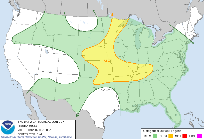
Bookmarks