
Originally Posted by
Thunder

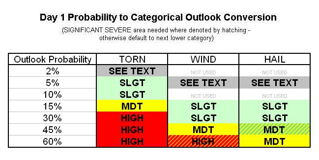
The chances are there. All of that. There is the potential. I think this is the greatest potential of the season so far and that the coverage is now including the western half. Slight risk that I see now and possibly upgrade to Mod risk (just my opinion) tomorrow maybe. I dunno, Venture knows it all, tho. :-)
His best advice will be just to be prepared. That is all we can do. Just be prepared and expect to change plans, etc. Keep watch on the weather, etc, there are multiple text and email alerts you can subscribe to for current on-goings. There are a whole lot of factors in play.
Its like next to impossible to predict if there will be long-track tornadoes, etc. Each storm/super cell has a mind of their own and it just depend. But the chances is there for severe storms with the potential. That is the best I can say. Venture can provide more.


 Reply With Quote


Bookmarks