Widgets Magazine
Page 10 of 16 FirstFirst ... 56789101112131415 ... LastLast
Results 226 to 250 of 378

Thread: Oklahoma Severe Weather Discussion - May 2011

  1. Default Re: Oklahoma Severe Weather Discussion - May 2011

    http://www.spc.noaa.gov/products/out...0523_1630.html


    DAY 1 CONVECTIVE OUTLOOK
    NWS STORM PREDICTION CENTER NORMAN OK
    1127 AM CDT MON MAY 23 2011

    VALID 231630Z - 241200Z

    ...THERE IS A MDT RISK OF SVR TSTMS ACROSS PORTIONS OF WESTERN AND
    NORTHERN OK...SOUTHEAST KS...AND SOUTHWEST MO...

    ...THERE IS A SLGT RISK OF SVR TSTMS OVER A LARGE AREA FROM THE
    SOUTHERN PLAINS...ACROSS THE MID MS AND OH VALLEYS...INTO NY/PA AND
    THE MID ATLANTIC REGION...

    A VERY COMPLEX CONVECTIVE DAY IS FORECAST ACROSS THE UNITED STATES
    TODAY...WITH NUMEROUS AREAS OF SEVERE WEATHER POTENTIAL.

    ...CENTRAL/SOUTHERN PLAINS...
    ISOLATED THUNDERSTORMS HAVE DEVELOPED NEAR DFW TODAY...AND ARE
    EXPECTED TO TRACK EASTWARD THROUGH THE DAY WITH A CONTINUED RISK OF
    ISOLATED SEVERE WEATHER. BEHIND THIS ACTIVITY...STRONG HEATING AND
    DEWPOINTS IN THE UPPER 60S TO LOWER 70S WILL YIELD AFTERNOON MLCAPE
    VALUES OF 4000-5000 J/KG AND A WEAK CAP. A SHORTWAVE TROUGH MOVING
    ACROSS WEST TX WILL LIKELY RESULT IN THE DEVELOPMENT A FEW DISCRETE
    SUPERCELL THUNDERSTORMS BY MID AFTERNOON OVER WESTERN OK. STORMS
    WILL ALSO LIKELY DEVELOP BY EARLY EVENING IN VICINITY OF REMNANT
    OUTFLOW BOUNDARIES OVER NORTHERN OK/SOUTHERN KS. BACKING LOW LEVEL
    FLOW THROUGH THE EVENING WILL PROMOTE UPDRAFT ROTATION WITH RISK OF
    VERY LARGE HAIL AND A FEW TORNADOES THROUGH THE EVENING.
    OVERNIGHT... GENERAL MODEL CONCENSUS SUGGESTS STORMS MAY GROW
    UPSCALE OVERNIGHT WITH AN MCS TRACKING TO AR WITH A RISK OF HAIL AND
    DAMAGING WINDS.

  2. #227

    Default Re: Oklahoma Severe Weather Discussion - May 2011

    so mister Thunder, r u taking over ventures job? jk.. I hope we dont get anything like joplin, but i do hope something takes my lemon of a car and mangles it, i really want a different car, My car isnt that old but has problems like very 6 months sincei have bought it!

  3. Default Re: Oklahoma Severe Weather Discussion - May 2011

    I am his assistant.

  4. Default Re: Oklahoma Severe Weather Discussion - May 2011

    Quote Originally Posted by Thunder View Post
    I am his assistant.
    Call me shocked. :-P

    Anyway. Initiation should be taking place in about 2-3 hours across western OK. Storms will probably be nearing the Metro are by 5-7PM.

  5. Default Re: Oklahoma Severe Weather Discussion - May 2011

    I love you, too.


    HAZARDOUS WEATHER OUTLOOK
    NATIONAL WEATHER SERVICE NORMAN OK
    1155 AM CDT MON MAY 23 2011

    OKZ004>048-050>052-TXZ083>090-231700-
    HARPER-WOODS-ALFALFA-GRANT-KAY-ELLIS-WOODWARD-MAJOR-GARFIELD-NOBLE-
    ROGER MILLS-DEWEY-CUSTER-BLAINE-KINGFISHER-LOGAN-PAYNE-BECKHAM-
    WA****A-CADDO-CANADIAN-OKLAHOMA-LINCOLN-GRADY-MCCLAIN-CLEVELAND-
    POTTAWATOMIE-SEMINOLE-HUGHES-HARMON-GREER-KIOWA-JACKSON-TILLMAN-
    COMANCHE-STEPHENS-GARVIN-MURRAY-PONTOTOC-COAL-COTTON-JEFFERSON-
    CARTER-JOHNSTON-ATOKA-LOVE-MARSHALL-BRYAN-HARDEMAN-FOARD-WILBARGER-
    WICHITA-KNOX-BAYLOR-ARCHER-CLAY-
    1155 AM CDT MON MAY 23 2011

    THIS HAZARDOUS WEATHER OUTLOOK COVERS NORTHERN...WESTERN...
    CENTRAL...AND SOUTHERN OKLAHOMA...AND WESTERN NORTH TEXAS.

    .DAY ONE...TODAY AND TONIGHT...

    THUNDERSTORM OUTLOOK...
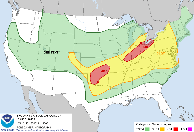
    THERE IS A MODERATE RISK OF SEVERE THUNDERSTORMS ACROSS PORTIONS OF
    CENTRAL AND WESTERN OKLAHOMA.
    THERE IS A SLIGHT RISK OF SEVERE
    THUNDERSTORMS ACROSS MUCH OF THE REMAINDER OF OKLAHOMA AND WESTERN
    NORTH TEXAS.

    LOCATION...
    THE MODERATE RISK IS EAST OF A WOODWARD TO ALTUS LINE...AND NORTH OF
    A FREDERICK TO WAURIKA TO HOLDENVILLE LINE. THE SLIGHT RISK IS SOUTH
    AND WEST OF THE MODERATE RISK ACROSS THE REMAINDER OF OKLAHOMA AND
    WESTERN NORTH TEXAS.

    IMPACTS...DAMAGE TO HOMES...CARS AND VEGETATION POSSIBLE FROM HAIL
    TO THE SIZE OF BASEBALLS AND DAMAGING WIND GUSTS OVER 65 MPH.


    TIMING...
    THE MOST LIKELY TIME FOR SEVERE WEATHER WILL BE THIS AFTERNOON AND
    EVENING... ALTHOUGH THE RISK OF SEVERE WEATHER WILL CONTINUE
    OVERNIGHT.

    RECOMMENDED ACTIONS...
    STORM SPOTTER GROUPS AND EMERGENCY MANAGEMENT PERSONNEL ACROSS THE
    RISK AREA SHOULD PLAN FOR THE POTENTIAL OF SEVERE WEATHER OPERATIONS
    THIS AFTERNOON THROUGH THE OVERNIGHT HOURS.

    DISCUSSION...
    A DRYLINE ACROSS THE OKLAHOMA AND TEXAS PANHANDLE WILL MOVE TO NEAR
    THE BORDER OF WESTERN OKLAHOMA AND THE TEXAS PANHANDLE THIS
    AFTERNOON. MEANWHILE...A COLD FRONT WILL BECOME STATIONARY ACROSS
    NORTHWEST OKLAHOMA...WHILE AN OUTFLOW BOUNDARY FROM STORMS IN
    NORTHEAST OKLAHOMA REMAINS IN NORTH CENTRAL OKLAHOMA. THUNDERSTORMS
    WILL LIKELY DEVELOP THIS AFTERNOON... ESPECIALLY NEAR THE FRONT
    AND OUTFLOW BOUNDARY IN THE NORTH... WITH OTHER STORMS POTENTIALLY
    DEVELOPING NEAR THE DRYLINE ACROSS WESTERN OKLAHOMA AND WESTERN
    NORTH TEXAS. OTHER ISOLATED STORMS MAY DEVELOP ELSEWHERE ACROSS THE
    AREA THIS AFTERNOON AND EVENING. THE ATMOSPHERE WILL ONCE AGAIN
    BE VERY UNSTABLE OVER OKLAHOMA AND NORTH TEXAS AND WILL SUPPORT
    SUPERCELLS CAPABLE OF PRODUCING HAIL LARGER THAN BASEBALLS...
    DAMAGING WINDS OVER 65 MPH... AND ISOLATED TORNADOES.
    STORMS WILL
    LIKELY BECOME MORE WIDESPREAD THIS EVENING AS THEY MOVE EASTWARD
    ACROSS OKLAHOMA AND NORTH TEXAS WITH THE CONTINUED POTENTIAL FOR
    SCATTERED SEVERE THUNDERSTORMS.

    PROBABILITY TABLE...
    VALID THROUGH 700 AM CDT TUESDAY MAY 24.
    PROBABILITY OF THUNDERSTORMS OCCURRING IN THE
    NWS NORMAN COUNTY WARNING AREA...80 PERCENT.
    PROBABILITY OF SEVERE STORMS IF STORMS OCCUR...100 PERCENT.
    Tomorrow and onward...

    .DAYS TWO THROUGH SEVEN...TUESDAY THROUGH SUNDAY...

    THUNDERSTORM OUTLOOK...
    THERE IS A POTENTIAL FOR MORE WIDESPREAD AND SIGNIFICANT SEVERE
    WEATHER ON TUESDAY...ESPECIALLY NEAR AND EAST OF INTERSTATE 35 WHERE
    THERE IS A MODERATE RISK OF SEVERE THUNDERSTORMS. SEVERE STORMS ARE
    EXPECTED TO DEVELOP BY AFTERNOON AS A STRONG UPPER SYSTEM LIFTS
    NORTHEASTWARD FROM THE SOUTHERN ROCKIES AND INTERACTS WITH A
    STRENGTHENING DRYLINE PUSHING INTO OKLAHOMA AND WESTERN NORTH TEXAS.
    VERY LARGE HAI...DAMAGING WINDS...AND TORNADOES WILL BE POSSIBLE.
    THUNDERSTORM CHANCES CONTINUE WEDNESDAY AND WEDNESDAY NIGHT ALTHOUGH
    THE RISK OF SEVERE WEATHER WILL LIKELY MOVE EAST OF THE AREA.

  6. Default Re: Oklahoma Severe Weather Discussion - May 2011

    Tomorrow, a new SPC (or discussion) just came out with possible upgrade...

    TORNADIC OUTBREAK POSSIBLE ACROSS THE CENTRAL AND SOUTHERN PLAINS TUESDAY. AN UPGRADE TO HIGH RISK MAY BE WARRANTED AS SITUATION BECOMES MORE CERTAIN...

  7. #232

    Default Re: Oklahoma Severe Weather Discussion - May 2011

    I don't see it happening.

    First off, I have always thought the weathermen here are full of crap and overdramatise things, as if they're hard up for action. I just watched the weather and they showed their predictor, which already seems to be wrong.

    Second off, I don't think tornadoes can hit certain parts of OKC. The part I refer to is the inner ring of the OKC metro. I've been right all these years, and I don't myself being proven wrong anytime soon.

    The inner ring I consist of is the square area surrounded by I-44, I-40, I-35, and I-240.

    I just don't see much happening today.

  8. Default Re: Oklahoma Severe Weather Discussion - May 2011


    DAY 2 CONVECTIVE OUTLOOK
    NWS STORM PREDICTION CENTER NORMAN OK
    1216 PM CDT MON MAY 23 2011

    VALID 241200Z - 251200Z

    ...THERE IS A MDT RISK OF SVR TSTMS FROM NWRN TX TO SRN NEB...

    ...THERE IS A SLGT RISK OF SVR TSTMS SURROUNDING THE MDT RISK OVER
    THE SRN/CNTRL PLAINS THROUGH THE OH/TN VALLEY TO SRN NY...


    ...TORNADIC OUTBREAK POSSIBLE ACROSS THE CENTRAL AND SOUTHERN PLAINS
    TUESDAY. AN UPGRADE TO HIGH RISK MAY BE WARRANTED AS SITUATION
    BECOMES MORE CERTAIN.
    ..


    A CLASSIC PLAINS TORNADIC OUTBREAK APPEARS TO BE EVOLVING ACROSS THE
    CNTRL/SRN PLAINS...ESPECIALLY FOR KANSAS AND OKLAHOMA. LATEST MODEL
    GUIDANCE IS CONSISTENT REGARDING THE PROGRESSION OF A VERY STRONG
    MID LEVEL SHORTWAVE TROUGH...CURRENTLY DIGGING ESEWD ACROSS SRN
    CA...INTO THE SWRN U.S./SRN ROCKIES BEFORE EJECTING INTO THE PLAINS
    BY PEAK HEATING. A VERY DIFFLUENT UPPER FLOW REGIME WILL OVERSPREAD
    THE PLAINS AS 30-60M 12HR HEIGHT FALLS EDGE EWD. ADDITIONALLY...H5
    SPEED MAX APPROACHING 80-90KT...AS NOTED IN THE GFS...WILL RACE TO A
    POSITION OVER NWRN TX/SWRN OK BY 25/00Z WHICH WILL GENERATE VERY
    STRONG SHEAR ACROSS THE WARM SECTOR FOR AREAS NEAR THE RED RIVER
    REGION...NWD INTO KS AND EVEN SRN NEB. NEEDLESS TO SAY A VERY
    DYNAMIC SHORTWAVE TROUGH SHOULD TIME FAVORABLY FOR RAPID SEVERE
    THUNDERSTORM INITIATION ALONG/AHEAD OF THE DRYLINE AS ATMOSPHERIC
    HEATING IS MAXIMIZED.

    EARLY IN THE MORNING A FEW THUNDERSTORM CLUSTERS MAY BE ONGOING
    WITHIN THE STRONGEST ZONE OF WARM ADVECTION FROM KS EWD INTO MO AND
    THE LOWER OH VALLEY. THIS REGION OF ASCENT AND STORMS MAY
    TEMPORARILY FORCE A CONVECTIVE OUTFLOW INTO NRN AR...NWWD INTO SRN
    KS. HOWEVER...A NWD RETREAT IS LIKELY TO AT LEAST THE I-70 CORRIDOR
    IN KS AS DAYTIME HEATING OCCURS ACROSS THE WARM SECTOR. FOR THIS
    REASON IT APPEARS A VERY UNSTABLE AIRMASS WILL BE IN PLACE FROM NRN
    TX INTO SRN KS WHERE SBCAPE VALUES COULD EXCEED 5000 J/KG WHERE SFC
    DEW POINTS HOLD IN THE LOWER 70S. FORECAST SOUNDINGS ACROSS THE
    WARM SECTOR EXHIBIT CLASSIC TORNADIC SUPERCELL STRUCTURES WITH
    STRONG LOW LEVEL HELICITY ACROSS KS/OK WITH DEEP LAYER SHEAR ON THE
    ORDER OF 50-60KT. BY MID AFTERNOON...STRONG HEATING SHOULD BE NOTED
    ALONG/WEST OF THE DRYLINE FORCING TEMPERATURES TO SOAR WELL INTO THE
    90S...EFFECTIVELY REMOVING INHIBITION FOR CONVECTIVE DEVELOPMENT
    WHERE LOW LEVEL CONVERGENCE IS MAXIMIZED. AT THIS TIME IT APPEARS
    TSTMS SHOULD INITIATE ALONG THE DRYLINE BY 21Z...ALTHOUGH ACTIVITY
    COULD DEVELOP MUCH QUICKER WITHIN THE STRONGER FORCING ACROSS THE
    CNTRL HIGH PLAINS TO THE NORTH-EAST OF THE SFC LOW WITHIN STRONGEST
    UPSLOPE FLOW.

    WHILE DRYLINE SUPERCELLS LIFE CYCLE WILL BE MAXIMIZED BETWEEN
    21Z-04Z...STRONG WARM ADVECTION ACROSS THE CNTRL PLAINS SHOULD
    MAINTAIN A ZONE OF CONCENTRATED SEVERE NEAR/NORTH OF THE WARM FRONT
    ACROSS KS/NEB INTO MO DURING THE OVERNIGHT HOURS.

  9. Default Re: Oklahoma Severe Weather Discussion - May 2011

    megax11, be patience. It takes time for these storms to form and so on. No one is saying anything about a tornado will definitely hit the inner metro ring. Relax. And don't pay much attention to those gadgets they show on television.

  10. Default Re: Oklahoma Severe Weather Discussion - May 2011

    Quote Originally Posted by megax11 View Post
    I don't see it happening.

    First off, I have always thought the weathermen here are full of crap and overdramatise things, as if they're hard up for action. I just watched the weather and they showed their predictor, which already seems to be wrong.

    Second off, I don't think tornadoes can hit certain parts of OKC. The part I refer to is the inner ring of the OKC metro. I've been right all these years, and I don't myself being proven wrong anytime soon.

    The inner ring I consist of is the square area surrounded by I-44, I-40, I-35, and I-240.

    I just don't see much happening today.
    Luckily the information here isn't from the guys on TV you don't like.

    A tornado can hit any part of the city it wants to, it is just a matter of time. People thought for years Norman couldn't be hit, than the EF-4 last year.

  11. #236

    Default Re: Oklahoma Severe Weather Discussion - May 2011

    Quote Originally Posted by megax11 View Post
    I don't see it happening.

    First off, I have always thought the weathermen here are full of crap and overdramatise things, as if they're hard up for action. I just watched the weather and they showed their predictor, which already seems to be wrong.

    Second off, I don't think tornadoes can hit certain parts of OKC. The part I refer to is the inner ring of the OKC metro. I've been right all these years, and I don't myself being proven wrong anytime soon.

    The inner ring I consist of is the square area surrounded by I-44, I-40, I-35, and I-240.

    I just don't see much happening today.
    I work in TV and yes the TV weatherguys do tend to go with the worst case scenario, they do have their reasons and some of them are legitimate. However I tend to believe it when the weatherservice starts talking about it too. IMO they dont have much of a reason to hype..

  12. #237

    Default Re: Oklahoma Severe Weather Discussion - May 2011

    A lot more clouds than yesterday, esp. east of I-35. If it stays that way it could limit the severity of today's storms.

  13. #238
    Uncle Slayton Guest

    Default Re: Oklahoma Severe Weather Discussion - May 2011

    You'd think that with downtown Fort Worth being hit as well as Nashville, that the evidence would disabuse anyone of the notion that they are geographically limited to where they can form. Dallas has been blasted as well a few times in the 50s. Had a great aunt in Dallas who was mortally afraid of tornadoes, that she would die in one. Then, when the one hit Oak Cliff in 1957, she panicked herself into a massive coronary and died. Turns out she was right all along...

  14. Default Re: Oklahoma Severe Weather Discussion - May 2011

    Quote Originally Posted by BG918 View Post
    A lot more clouds than yesterday, esp. east of I-35. If it stays that way it could limit the severity of today's storms.
    Our storms are going to feed off the instability to the west of I-35. CAPE values are already well over 4000 j/kg and CIN is virtually gone. Clouds to the east are a non-factor for the Metro area.

  15. #240

    Default Re: Oklahoma Severe Weather Discussion - May 2011

    I'm not so sure if its possible to "feel" instability, but something about today just doesn't feel right. Its cloudy but very warm and the humidity is absolutely disgusting outside, probably the most uncomfortable its been so far this spring. Plus there's a gentle SE breeze but the clouds are moving almost due west from what I can tell. Maybe its because I've got those images of Joplin stuck in my head, but I just feel a bit concerned about today and tommorow.

    Quote Originally Posted by Uncle Slayton View Post
    You'd think that with downtown Fort Worth being hit as well as Nashville, that the evidence would disabuse anyone of the notion that they are geographically limited to where they can form. Dallas has been blasted as well a few times in the 50s.
    Don't forget downtown Atlanta in 2008 during the Final Four. Plus, my parents area in Collin County, just north of Dallas, has had one touchdown and a few very near misses in the past 3 years. This is in an area with about 4-5000 people per square mile. And I lived there about 8 years before relocating to Norman without ever experiencing such a thing, so the fact that a tornado hasn't struck the in-town areas of OKC means nothing at this point.

  16. Default Re: Oklahoma Severe Weather Discussion - May 2011

    Quote Originally Posted by adaniel View Post
    I'm not so sure if its possible to "feel" instability, but something about today just doesn't feel right. Its cloudy but very warm and the humidity is absolutely disgusting outside, probably the most uncomfortable its been so far this spring. Plus there's a gentle SE breeze but the clouds are moving almost due west from what I can tell. Maybe its because I've got those images of Joplin stuck in my head, but I just feel a bit concerned about today and tomorrow.
    I have to agree with you. I don't like the way it feels outside. It's just nasty. Guess I'll bring down the cat crates in case I have to make a quick escape to the laundry room.
    Still corrupting young minds

  17. #242

    Default Re: Oklahoma Severe Weather Discussion - May 2011

    It was a couple years ago but I was listening to an actuary for an insurance company talk about the percentage of likelihood of a tornado directly affecting an individual who lives a life of 80 years in either Kansas or Oklahoma, and the final number was 4% over 80 years. I believe it was in some way regarding the pricing of property insurance.

    It sure as hell seems like a higher chance when watching the local tv weather !!!

  18. #243

    Default Re: Oklahoma Severe Weather Discussion - May 2011

    Thirded. It's the classic type of weather that usually occurs before a major tornadic storm.

  19. #244

    Default Re: Oklahoma Severe Weather Discussion - May 2011

    Tornado watch now out. Includes most of the western half of Oklahoma, but not Oklahoma County.

  20. Default Re: Oklahoma Severe Weather Discussion - May 2011

    The watch will expand as the storms evolution continues to grow and move eastward.

  21. Default Re: Oklahoma Severe Weather Discussion - May 2011


    URGENT - IMMEDIATE BROADCAST REQUESTED
    TORNADO WATCH NUMBER 345
    NWS STORM PREDICTION CENTER NORMAN OK
    230 PM CDT MON MAY 23 2011

    THE NWS STORM PREDICTION CENTER HAS ISSUED A
    TORNADO WATCH FOR PORTIONS OF

    WESTERN OKLAHOMA
    NORTHWEST TEXAS

    EFFECTIVE THIS MONDAY AFTERNOON AND EVENING FROM 230 PM UNTIL
    1000 PM CDT.

    SEVERAL TORNADOES
    ISOLATED INTENSE TORNADOES POSSIBLE
    WIDELY SCATTERED DAMAGING WINDS
    ISOLATED WIND GUSTS TO 70 MPH POSSIBLE
    WIDESPREAD LARGE HAIL
    HAIL TO 3.0 INCHES IN DIAMETER LIKELY

    THE TORNADO WATCH AREA IS APPROXIMATELY ALONG AND 60 STATUTE
    MILES EAST AND WEST OF A LINE FROM 25 MILES NORTHEAST OF ALVA
    OKLAHOMA TO 40 MILES SOUTH SOUTHEAST OF ALTUS OKLAHOMA. FOR A
    COMPLETE DEPICTION OF THE WATCH SEE THE ASSOCIATED WATCH OUTLINE
    UPDATE (WOUS64 KWNS WOU5).

    REMEMBER...A TORNADO WATCH MEANS CONDITIONS ARE FAVORABLE FOR
    TORNADOES AND SEVERE THUNDERSTORMS IN AND CLOSE TO THE WATCH
    AREA. PERSONS IN THESE AREAS SHOULD BE ON THE LOOKOUT FOR
    THREATENING WEATHER CONDITIONS AND LISTEN FOR LATER STATEMENTS
    AND POSSIBLE WARNINGS.

    OTHER WATCH INFORMATION...CONTINUE...WW 338...WW 339...WW
    340...WW 341...WW 342...WW 343...WW 344...

    DISCUSSION...TCU/INCIPIENT TSTM DEVELOPMENT IS IN PROGRESS ALONG
    DRYLINE IN WRN OK SW OF CSM. MODIFICATION OF 19Z OUN SOUNDING FOR
    AIR MASS IMMEDIATELY E OF DRYLINE SUGGESTS THAT ENVIRONMENT IS
    NEARLY UNCAPPED WITH MLCAPE OF 4000-5000 J/KG. WHILE PASSAGE OF
    SHORT WAVE TROUGH TO THE NE IS NOT PARTICULARLY WELL-TIMED...STRONG
    DIABATIC HEATING W OF DRYLINE SHOULD SERVE TO FOSTER AT LEAST
    ISOLATED STORM DEVELOPMENT THIS AFTERNOON INTO EVENING.
    INITIALLY...VERY LARGE HAIL WILL BE THE PRIMARY HAZARD WITH MATURE
    SUPERCELLS GIVEN THE LOCALLY HIGHER T-TD SPREADS AND WEAK LOW-LEVEL
    FLOW. THE POTENTIAL FOR TORNADOES WILL INCREASE THIS EVENING AS
    LOW-LEVEL SHEAR STRENGTHENS AND LCL HEIGHTS LOWER.

    AVIATION...TORNADOES AND A FEW SEVERE THUNDERSTORMS WITH HAIL
    SURFACE AND ALOFT TO 3 INCHES. EXTREME TURBULENCE AND SURFACE
    WIND GUSTS TO 60 KNOTS. A FEW CUMULONIMBI WITH MAXIMUM TOPS TO
    600. MEAN STORM MOTION VECTOR 27020.


    TORNADO WATCH PROBABILITIES FOR WT 0345
    NWS STORM PREDICTION CENTER NORMAN OK
    0234 PM CDT MON MAY 23 2011

    WT 0345
    PROBABILITY TABLE:
    PROB OF 2 OR MORE TORNADOES : 60%
    PROB OF 1 OR MORE STRONG /F2-F5/ TORNADOES : 50%
    PROB OF 10 OR MORE SEVERE WIND EVENTS : 30%
    PROB OF 1 OR MORE WIND EVENTS >= 65 KNOTS : 30%
    PROB OF 10 OR MORE SEVERE HAIL EVENTS : 80%
    PROB OF 1 OR MORE HAIL EVENTS >= 2 INCHES : 90%
    PROB OF 6 OR MORE COMBINED SEVERE HAIL/WIND EVENTS : 90%

    &&
    ATTRIBUTE TABLE:
    MAX HAIL /INCHES/ : 3.0
    MAX WIND GUSTS SURFACE /KNOTS/ : 60
    MAX TOPS /X 100 FEET/ : 600
    MEAN STORM MOTION VECTOR /DEGREES AND KNOTS/ : 27020
    PARTICULARLY DANGEROUS SITUATION : NO

  22. #247

    Default Re: Oklahoma Severe Weather Discussion - May 2011

    Joplin, SE Kansas and NW Arkansas can't get a break from all the rain and storms this year.

  23. #248

    Default Re: Oklahoma Severe Weather Discussion - May 2011

    This significant weather advisory is for logan...noble and payne counties. At 504 pm cdt...a line of strong thunderstorms was located from 12 miles west of ceres to 6 miles northwest of cedar valley...moving east at 35 mph. Hazards include...
    Hail up to the size of nickels...
    Wind gusts to 50 mph...
    Storm intensity is increasing and severe weather may develop rapidly. Stay alert and listen for warnings.

  24. #249

    Default Re: Oklahoma Severe Weather Discussion - May 2011

    Tornado watch now includes Lincoln and Payne Counties.

  25. #250

    Default Re: Oklahoma Severe Weather Discussion - May 2011

    When will there be a reasonable idea about how tonight’s activity will be affecting tomorrow’s storms?

Thread Information

Users Browsing this Thread

There are currently 1 users browsing this thread. (0 members and 1 guests)

Similar Threads

  1. Oklahoma Fire Weather Discussion 2011
    By venture in forum Weather & Geosciences
    Replies: 17
    Last Post: 06-14-2011, 10:54 AM
  2. Oklahoma Severe Weather Discussion - April 2011
    By venture in forum Weather & Geosciences
    Replies: 286
    Last Post: 04-29-2011, 11:28 PM
  3. Oklahoma Severe Weather Discussion - March 2011
    By venture in forum Weather & Geosciences
    Replies: 94
    Last Post: 04-03-2011, 10:39 AM
  4. Winter Weather Discussion - Jan/Feb 2011
    By venture in forum Weather & Geosciences
    Replies: 620
    Last Post: 02-23-2011, 01:31 AM
  5. Winter Weather Discussion - Feb 2011
    By Matt in forum Current Events & Open Topic
    Replies: 0
    Last Post: 01-31-2011, 01:28 AM

Bookmarks

Posting Permissions

  • You may not post new threads
  • You may not post replies
  • You may not post attachments
  • You may not edit your posts
  •  
Single Sign On provided by vBSSO