Widgets Magazine
Results 1 to 18 of 18

Thread: Oklahoma Fire Weather Discussion 2011

  1. Default Oklahoma Fire Weather Discussion 2011

    This thread is meant for the discussion on the fire dangers in Oklahoma during this drought. This topic was normally lumped in with the main weather thread, but since severe weather season is going now I want to keep both topics from getting taken over by the other.


    _________Norman Warning Area Map __________________ Tulsa County Warning Area Map____

    Red Flag Warning | Fire Warning | Fire Weather Watch | High Wind Warning | High Wind Watch | Wind Advisory

    Other Color Meanings: http://www.weather.gov/wwamap-prd/faq.php

    Norman County Warning Area Wildfire Potential


    Norman Fire Weather Planning Forecast

    SPC Fire Weather Outlooks

    ________ Day 1 ________________ Day 2 ______________ Days 3 to 8 _____


    *Click any above graphic to view discussion.*

    CoD Visible Satellite Image (will appear blank overnight)


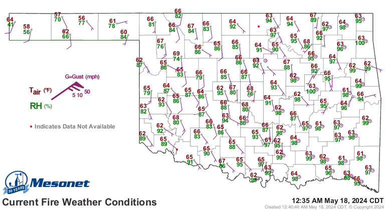
    Oklahoma Mesonet Current Conditions


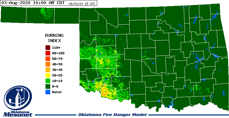
    Oklahoma Fire Danger Model - Burning Index


    Oklahoma Mesonet Fire Weather Graphics
    Spread Component | Energy Release Component | Ignition Component | 1-h Dead Fuel Moisture | 10-h Dead Fuel Moisture | 100-h Dead Fuel Moisture | 1000-h Dead Fuel Moisture | Live Herbaceous Moisture | Live Woody Moisture | KBDI | Visual Greenness | Relative Greenness

    Useful Links
    OK-FIRE Mesonet Site: http://okfire.mesonet.org/
    COD Weather Analysis Page: http://weather.cod.edu/analysis/
    NWS Norman Enhanced Page: http://www.srh.noaa.gov/oun/enhanced.php
    Storm Prediction Center: http://www.spc.noaa.gov/
    Oklahoma Mesonet: http://www.mesonet.org/
    West Texas Mesonet: http://www.mesonet.ttu.edu/
    Oklahoma Fire Weather: http://www.srh.noaa.gov/oun/?n=fireweather
    Oklahoma Road Conditions: http://www.dps.state.ok.us/cgi-bin/weathermap.cgi
    Severe Weather Values Reference Guide: http://weatherspotter.net/index11.php -or- http://www.theweatherprediction.com/severe/indices/
    TwisterData Model Page: http://www.twisterdata.com/
    Earl Barker's Central US Model Page: http://128.121.193.153/central_models.htm
    NSSL WRF Model: http://www.nssl.noaa.gov/wrf/
    NSSL 4KM WRF Model Forecast Soundings: http://www.nssl.noaa.gov/wrf/sdg/

  2. Default Re: Oklahoma Fire Weather Discussion 2011

    Fire Warning in Comanche County...

    BULLETIN - EAS ACTIVATION REQUESTED
    FIRE WARNING
    COMANCHE COUNTY EMERGENCY MANAGEMENT
    RELAYED BY NATIONAL WEATHER SERVICE NORMAN OK
    143 PM CDT FRI APR 15 2011

    THE FOLLOWING MESSAGE IS BEING TRANSMITTED AT THE REQUEST OF THE
    COMANCHE COUNTY EMERGENCY MANAGER.

    PEOPLE IN AN AREA BOUNDED BY SW LEE BOULEVARD...SW 112TH STREET...SW
    TINNEY ROAD...AND SW 38TH ST SHOULD EVACUATE TOWARD THE EAST. A
    LARGE FIRE LOCATED NEAR LEE AND 112TH WILL SPREAD QUICKLY SOUTHEAST.

  3. Default Re: Oklahoma Fire Weather Discussion 2011

    Some massive fires burnings out there now in SW OK / NW TX.


    Smoke plumes very visible on satellite.


  4. Default Re: Oklahoma Fire Weather Discussion 2011

    Bulletin - eas activation requested
    fire warning
    comanche county emergency management
    relayed by national weather service norman ok
    430 pm cdt fri apr 15 2011

    the following message is being transmitted at the request of the
    comanche county emergency manager.

    A large grass fire is located near mcintosh and tackle box roads
    and is moving rapidly southeast. People in an area bounded by
    mcintosh and tackle box roads...and allison and stony point should
    evacuate to the east.

  5. Default Re: Oklahoma Fire Weather Discussion 2011

    It is funny how on a recent day, everyone was so hyped about fire warnings and so prepared for major fire disasters only to see the surface wind a bust. Then today... Not much hype. We have the surface wind, quite strongly, in fact more stronger than the previous hyped fire day, but no fire that I am aware of around here except for extreme far southwestern portion.

    Okay, we are very dry and very windy right now, but no major fire outbreaks? Could the temperature be the reason for it?

  6. #6

    Default Re: Oklahoma Fire Weather Discussion 2011

    Quote Originally Posted by Thunder View Post
    It is funny how on a recent day, everyone was so hyped about fire warnings and so prepared for major fire disasters only to see the surface wind a bust. Then today... Not much hype. We have the surface wind, quite strongly, in fact more stronger than the previous hyped fire day, but no fire that I am aware of around here except for extreme far southwestern portion.

    Okay, we are very dry and very windy right now, but no major fire outbreaks? Could the temperature be the reason for it?
    Temperature is a big part of it. Also, were starting to green up.

  7. Default Re: Oklahoma Fire Weather Discussion 2011

    Critical/Extreme fire conditions to return to Central/Western OK for Sunday and a Fire Weather Watch is now up for the entire area.

    URGENT - FIRE WEATHER MESSAGE
    NATIONAL WEATHER SERVICE NORMAN OK
    559 PM CDT SAT APR 16 2011

    OKZ004>015-017>021-024>031-040>042-046-050-171000-
    /O.EXB.KOUN.FW.A.0022.110417T1600Z-110418T0100Z/
    HARPER-WOODS-ALFALFA-GRANT-KAY-ELLIS-WOODWARD-MAJOR-GARFIELD-
    NOBLE-ROGER MILLS-DEWEY-BLAINE-KINGFISHER-LOGAN-PAYNE-BECKHAM-
    CANADIAN-OKLAHOMA-LINCOLN-GRADY-MCCLAIN-CLEVELAND-POTTAWATOMIE-
    SEMINOLE-GARVIN-MURRAY-PONTOTOC-CARTER-LOVE-
    559 PM CDT SAT APR 16 2011

    ...FIRE WEATHER WATCH IN EFFECT FROM SUNDAY MORNING THROUGH
    SUNDAY EVENING FOR WESTERN NORTH TEXAS AND ALL OF WESTERN AND CENTRAL
    OKLAHOMA TO THE WEST OF A MARIETTA TO ADA TO PONCA CITY LINE...

    * WINDS...SOUTH TO SOUTHWEST 20 TO 25...GUSTING 35 TO 40 MPH.

    * HUMIDITY...12 TO 20 PERCENT.

    * TEMPERATURES...LOW 80S EAST AND NORTH...TO LOW 90S SOUTHWEST.

    * IMPACTS...ANY FIRES THAT DEVELOP WILL LIKELY SPREAD RAPIDLY.
    OUTDOOR BURNING IS NOT RECOMMENDED.

    PRECAUTIONARY/PREPAREDNESS ACTIONS...

    MONITOR WEATHER FORECASTS AND INFORMATION.

  8. #8

    Default Re: Oklahoma Fire Weather Discussion 2011

    I didn't fully grasp how dry we are this year until I took a drive yesterday over to the tiny little crick that sits in the middle of watershed, the one where Lake Draper ought to be.

    I Was completely stunned. I've never seen it so empty

  9. #9

    Default Re: Oklahoma Fire Weather Discussion 2011

    Quote Originally Posted by kevinpate View Post
    I didn't fully grasp how dry we are this year until I took a drive yesterday over to the tiny little crick that sits in the middle of watershed, the one where Lake Draper ought to be.

    I Was completely stunned. I've never seen it so empty
    If, by chance, you were referring to the lake itself, it was partially drained a year ago so that maintenance can be performed.


    Lake Stanley Draper by woodyrr, on Flickr

    Filling it back up when the work is completed might be an issue, however.

    On the scanner, I just heard the eastern Oklahoma County fire departments declare today a "war day" so they are getting ready to hit any fires that start very hard.

  10. #10

    Default Re: Oklahoma Fire Weather Discussion 2011

    Dinna know about it being drained on purpose. Had not been by for a good spell. I was shocked to see five of the fishing docks and a boat dock sitting on dry lake bottom with zero water within 100+ feet, and only a thin puddle strip then.
    Last edited by kevinpate; 04-17-2011 at 09:30 AM. Reason: typo

  11. Default Re: Oklahoma Fire Weather Discussion 2011

    Several fires going right now and smoke smell in Norman is getting pretty thick. Not sure where it is coming from though.

    Currently Active Fires (as of 2:55PM)
    - Cement, Caddo County
    - Velma, Stephens County
    - Comanche County - Trail Road: 50% contained
    - Crawford, Roger Mills
    - Pernell, Garven County
    Last edited by venture; 04-17-2011 at 01:59 PM. Reason: Updated fire list

  12. Default Re: Oklahoma Fire Weather Discussion 2011

    This is happening in Texas right now.

    http://kocoweatherblog.wordpress.com...9/texas-fires/

  13. Default Re: Oklahoma Fire Weather Discussion 2011

    Fire risk will start increasing through the week. Fire weather watches up for most of Western OK.

    URGENT - FIRE WEATHER MESSAGE
    NATIONAL WEATHER SERVICE NORMAN OK
    401 PM CDT WED APR 27 2011

    ...DRY WITH STRONG SOUTH WINDS ON FRIDAY...

    .GUSTY SOUTH WINDS AND WARM TEMPERATURES ARE EXPECTED ON FRIDAY
    AFTERNOON CREATING INCREASED FIRE POTENTIAL.

    OKZ004-009-014-280515-
    /O.EXA.KOUN.FW.A.0025.110429T1800Z-110430T0200Z/
    HARPER-ELLIS-ROGER MILLS-
    401 PM CDT WED APR 27 2011

    ...FIRE WEATHER WATCH IN EFFECT FROM FRIDAY AFTERNOON THROUGH
    FRIDAY EVENING FOR VERY WARM... DRY AND WINDY CONDITIONS FOR
    WESTERN OKLAHOMA AND WESTERN NORTH TEXAS...

    THE NATIONAL WEATHER SERVICE IN NORMAN HAS ISSUED A FIRE WEATHER
    WATCH...WHICH IS IN EFFECT FROM FRIDAY AFTERNOON THROUGH FRIDAY
    EVENING.

    * WINDS...SOUTH 20 TO 30...GUSTING 40 MPH.

    * HUMIDITY...15 TO 20 PERCENT.

    * TEMPERATURE...HIGH TEMPERATURES 80 TO 85.

    * IMPACTS...ANY FIRES THAT DEVELOP WILL LIKELY SPREAD RAPIDLY.
    OUTDOOR BURNING IS NOT RECOMMENDED.

    PRECAUTIONARY/PREPAREDNESS ACTIONS...

    MONITOR WEATHER FORECASTS AND INFORMATION.

    -----

    URGENT - FIRE WEATHER MESSAGE
    NATIONAL WEATHER SERVICE NORMAN OK
    401 PM CDT WED APR 27 2011

    ...DRY WITH STRONG SOUTH WINDS ON FRIDAY...

    .GUSTY SOUTH WINDS AND WARM TEMPERATURES ARE EXPECTED ON FRIDAY
    AFTERNOON CREATING INCREASED FIRE POTENTIAL.

    OKZ021-022-033>037-TXZ083>090-280515-
    /O.CON.KOUN.FW.A.0025.110429T1800Z-110430T0200Z/
    BECKHAM-WA****A-HARMON-GREER-KIOWA-JACKSON-TILLMAN-HARDEMAN-FOARD-
    WILBARGER-WICHITA-KNOX-BAYLOR-ARCHER-CLAY-
    401 PM CDT WED APR 27 2011

    ...FIRE WEATHER WATCH REMAINS IN EFFECT FROM FRIDAY AFTERNOON
    THROUGH FRIDAY EVENING FOR VERY WARM... DRY AND WINDY CONDITIONS FOR
    WESTERN OKLAHOMA AND WESTERN NORTH TEXAS...

    * WINDS...SOUTH 20 TO 30...GUSTING 40 MPH.

    * HUMIDITY...15 TO 20 PERCENT.

    * TEMPERATURE...HIGH TEMPERATURES 80 TO 93.

    * IMPACTS...ANY FIRES THAT DEVELOP WILL LIKELY SPREAD RAPIDLY.
    OUTDOOR BURNING IS NOT RECOMMENDED.

    PRECAUTIONARY/PREPAREDNESS ACTIONS...

    MONITOR WEATHER FORECASTS AND INFORMATION.

  14. Default Re: Oklahoma Fire Weather Discussion 2011

    Fire Weather Watch up for all of Western OK.

    URGENT - FIRE WEATHER MESSAGE...UPDATED
    NATIONAL WEATHER SERVICE NORMAN OK
    902 AM CDT TUE MAY 3 2011

    ...LOW HUMIDITIES AND STRONG SOUTH WINDS RETURN WEDNESDAY...

    OKZ004>006-009>011-014>017-021>023-033>038-044-032215-
    /O.EXA.KOUN.FW.A.0026.110504T1700Z-110505T0100Z/
    HARPER-WOODS-ALFALFA-ELLIS-WOODWARD-MAJOR-ROGER MILLS-DEWEY-
    CUSTER-BLAINE-BECKHAM-WA****A-CADDO-HARMON-GREER-KIOWA-JACKSON-
    TILLMAN-COMANCHE-COTTON-
    902 AM CDT TUE MAY 3 2011

    ...FIRE WEATHER WATCH IN EFFECT FROM WEDNESDAY AFTERNOON THROUGH
    WEDNESDAY EVENING...

    THE NATIONAL WEATHER SERVICE IN NORMAN HAS ISSUED A FIRE WEATHER
    WATCH...WHICH IS IN EFFECT FROM NOON WEDNESDAY THROUGH 8 PM WEDNESDAY
    EVENING.

    * WINDS...SOUTH 20 TO 30 MPH...GUSTING TO AROUND 40.

    * HUMIDITY...10 TO 20 PERCENT.

    * TEMPERATURE...74 TO 82.

    * IMPACTS...ANY FIRES THAT DEVELOP WILL LIKELY SPREAD RAPIDLY.
    OUTDOOR BURNING IS NOT RECOMMENDED.

    PRECAUTIONARY/PREPAREDNESS ACTIONS...

    MONITOR WEATHER FORECASTS AND INFORMATION.

  15. Default Re: Oklahoma Fire Weather Discussion 2011

    Red Flag warnings are up for Western OK (see maps in post #1)...


  16. Default Re: Oklahoma Fire Weather Discussion 2011

    Urgent - fire weather message
    national weather service norman ok
    356 am cdt sun may 8 2011

    ...hot dry and breezy weather today...

    Okz004>006-009>011-014>017-021>023-033>038-txz083>085-087-088-
    081700-
    /o.upg.koun.fw.a.0027.110508t1800z-110509t0100z/
    /o.new.koun.fw.w.0026.110508t1700z-110509t0200z/
    /o.new.koun.fw.a.0028.110509t1700z-110510t0200z/
    harper-woods-alfalfa-ellis-woodward-major-roger mills-dewey-
    custer-blaine-beckham-wa****a-caddo-harmon-greer-kiowa-jackson-
    tillman-comanche-hardeman-foard-wilbarger-knox-baylor-
    356 am cdt sun may 8 2011

    ...red flag warning in effect from noon today to 9 pm cdt this
    evening...
    ...fire weather watch in effect from monday afternoon through
    monday evening...

    The national weather service in norman has issued a red flag
    warning...which is in effect from noon today to 9 pm cdt this
    evening. A fire weather watch has also been issued. This fire
    weather watch is in effect from monday afternoon through monday
    evening.

    * wind...south-southwest 15 to 25 mph with gusts around 30.

    * humidity...5 to 15 percent.

    * temperature...afternoon highs 98 to 106.

    * impacts...any fires that develop will likely spread rapidly.
    Outdoor burning is not recommended.

    Precautionary/preparedness actions...

    Fires may start easily and spread rapidly. Report smoke or fire
    to your local fire department.

    Monitor weather forecasts and information.

  17. Default Re: Oklahoma Fire Weather Discussion 2011

    As expected, fire danger will start going up quite a bit through the upcoming week. Winds started Tuesday could be 30-40 mph or higher along and west of I-35. As we continue to dry out (well for those that got rain), we could start pushing the Very High to Extreme fire danger days again. This is going to be something to definitely watch as we get closer to the July 4th holiday. If we don't get rain between now and then, pretty wide spread burn bans are probably guaranteed which could severe limit any firework displays. Not to mention, the inherent risk of people who disregard the conditions and celebrate as they normally would.

  18. Default Re: Oklahoma Fire Weather Discussion 2011

    Plan appropriately for any outdoor's activities this weekend.

    From the Norman Morning Discussion:

    .FIRE WEATHER EPISODE THE UPCOMING WEEKEND...
    WEDNESDAY WILL BE LESS HOT AS THE FRONT REACHES NORTH TEXAS. EXPECT
    DIURNAL THUNDERSTORMS NEAR THE FRONT...WITH POTENTIAL TO PUSH BACK
    NORTH AND WEST ALONG OUTFLOW BOUNDARIES. REGARDING FRONTAL POSITION
    AND SYNOPTICS THE 00Z ECMWF WAS THE MODEL OF CHOICE...THOUGH
    DIFFERENCES WITH THE GFS WERE MINIMAL. AN 850 MB WARM FRONT WILL
    START TO TAKE SHAPE TO OUR NORTH ON THURSDAY...BUT THE SURFACE FRONT
    WILL BE SLOWER TO LIFT...RESULTING IN GRADUALLY HOTTER TEMPERATURES
    EXPANDING SOUTHWEST TO THE NORTHEAST THROUGH SATURDAY.

    THE PATTERN SETTING UP THIS WEEKEND CAUSES SIGNIFICANT CONCERN OVER
    FIRE WEATHER CONDITIONS. AS IT APPEARS NOW...A BROAD UPPER TROUGH
    WILL APPROACH SLOWLY...OVER A PERIOD OF DAYS. WINDS WILL INCREASE AT
    ALL LEVELS...MEANING A WINDY LOW LEVEL JET AHEAD OF THE DRYLINE AND
    DEEPLY MIXED GUSTY WINDS BEHIND THE DRYLINE. TEMPERATURES ARE
    FORECAST WELL ABOVE 100 DEGREES IN THE WEST...AND ANY THUNDERSTORM
    ACTIVITY WILL LIKELY PRODUCE LIGHTNING AND STRONG WINDS...BUT NOT A
    LOT OF RAINFALL. THE STRONGEST WINDS ARE CURRENTLY FORECAST TO OCCUR
    SUNDAY AND MONDAY...WHEN THE SURFACE LOW DEEPENS TO AROUND 990 MB
    FROM SOUTHEAST COLORADO TOWARD NORTHWEST OKLAHOMA. IF THE TRENDS
    HOLD UP...THIS COULD BE A MORE SIGNIFICANT FIRE WEATHER THREAT THAN
    THE RECENT EVENTS.

Thread Information

Users Browsing this Thread

There are currently 1 users browsing this thread. (0 members and 1 guests)

Similar Threads

  1. US Volcano Activity Discussion - 2011
    By venture in forum Current Events & Open Topic
    Replies: 9
    Last Post: 09-17-2011, 05:17 PM
  2. Oklahoma Severe Weather Discussion - April 2011
    By venture in forum Weather & Geosciences
    Replies: 286
    Last Post: 04-29-2011, 11:28 PM
  3. Oklahoma Severe Weather Discussion - March 2011
    By venture in forum Weather & Geosciences
    Replies: 94
    Last Post: 04-03-2011, 10:39 AM
  4. Winter Weather Discussion - Jan/Feb 2011
    By venture in forum Weather & Geosciences
    Replies: 620
    Last Post: 02-23-2011, 01:31 AM
  5. Winter Weather Discussion - Feb 2011
    By Matt in forum Current Events & Open Topic
    Replies: 0
    Last Post: 01-31-2011, 01:28 AM

Bookmarks

Posting Permissions

  • You may not post new threads
  • You may not post replies
  • You may not post attachments
  • You may not edit your posts
  •  
Single Sign On provided by vBSSO