

Glad I bought a jeep last week

 Participating Member

Glad I bought a jeep last week
Participating Member
My car is in dire need of a wash. Definitely not a detail, as that would be oxymoronish with the system coming in.
David
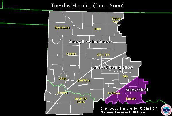
12Z model runs have a few changes, but not enough to warrant a full re-write just yet. NAM is colder with more snow. GFS is faster with the bulk of precip east of I-35. Not going to bother tweaking anything until tomorrow evening. The system will be coming on shore finally and a new set of real time observations will then be available to plug into the models.
Poster
Good morning, sir. I see the NAM is finally going colder with more snow. It took that frickin' model forever! But it is sad to see the GFS thinking it will move fast... What do the NAM think on the speed?
David
Appears NAM and GFS 12Z runs are essentially garbage this morning from a message sent out by the HPC. http://www.hpc.ncep.noaa.gov/discussions/pmdhmd.htmlOriginally Posted by Thunder

Preference is on the UK and European forecast models, which unfortunately aren't as widely available to the public.
Fire Weather Update from Norman...(graphic will auto update)

David
KWTV is streaming the Logan County wildfire...which appears to currently be consuming a house.
http://www.news9.com/global/video/fl...d&rnd=49486038
David
Going by the latest graphic/satellite, it looks like there are at least 40 wildfires going right now.
David
Update Discussion from Norman with some stronger wording being used.
AREA FORECAST DISCUSSION
NATIONAL WEATHER SERVICE NORMAN OK
320 PM CST SAT JAN 29 2011
.DISCUSSION...
FIRE... THEN ICE. DRY BREEZY AND RECORD OR NEAR-RECORD WARM CONDITIONS LEADING TO HOT SPOTS BREAKING OUT ALL ACROSS THE AREA THIS AFTERNOON. WINDS DECREASING THIS EVENING BEFORE SHIFTING TO NORTH AS COLD FRONT OVER CENTRAL/SW KS MOVES S THROUGH AREA TONIGHT BRINGING FIRST SHOT OF COLDER AIR. UPPER SYSTEM OVER TX WILL MAINTAIN LOW CHANCES OF -RA SE TONIGHT INTO SUNDAY.
COLD SFC HIGH HAS BUILT NICELY OVER CANADA AND WILL PROVIDE THE COLD AIR THROUGH MONDAY TO SET UP A POTENTIAL MAJOR MESS MONDAY NIGHT AND TUESDAY. WINTER STORM WATCH IS INEVITIBLE BUT WE WILL HOLD OFF FOR NOW DUE TO THE WORST OF THE EVENT LIKELY UNFOLDING IN PERIODS 5/6. STILL MANY VARIABLES AND UNCERTAINTIES REGARDING PRECIP TYPE AND AMOUNTS - ANOTHER REASON WE ARE HOLDING OFF ON HEADLINES FOR THE TIME BEING. IT LOOKS LIKE A TRANSITION FROM RA/DZ TO ICE TO SNOW WILL BE RATHER SWIFT AS THE COLD AIR POURS IN MONDAY NIGHT AND TUESDAY MORNING. LARGE-SCALE PATTERN FAVORS HEAVY SNOW SOMEWHERE ACROSS THE AREA BUT TRACK OF UPPER SYSTEM IS UNCERTAIN AND THEREFORE SO IS THE LOCATION OF THE HEAVIEST ACCUMULATIONS. STRONG WINDS LEADING TO BLOWING/DRIFTING SNOW AND POSSIBLY BLIZZARD OR NEAR-BLIZZARD CONDITIONS SOME AREAS BY TUESDAY... AND DANGEROUS WIND CHILLS -10 TO -20 BY WED MORNING.
ALL RESOURCES TODAY ARE BEING BROUGHT TO BEAR ON THE COMPLEX EVOLUTION OF EVENTS FROM NOW THROUGH TUE-WED... SO NO BIG CHANGES AT THIS TIME TO THE FORECAST BEYOND THAT.
David
Tulsa has gone ahead and put up Winter Storm Watches for counties in their area of responsibility.
URGENT - WINTER WEATHER MESSAGE
NATIONAL WEATHER SERVICE TULSA OK
353 PM CST SAT JAN 29 2011
...WINTER STORM WATCH IN EFFECT FROM MONDAY EVENING THROUGH WEDNESDAY MORNING...
THE NATIONAL WEATHER SERVICE IN TULSA HAS ISSUED A WINTER STORM WATCH...WHICH IS IN EFFECT FROM MONDAY EVENING THROUGH WEDNESDAY MORNING...
FOR THE FOLLOWING COUNTIES...
* IN OKLAHOMA...
WASHINGTON... WAGONER... OTTAWA... PAWNEE... DELAWARE... CHEROKEE... ADAIR... CRAIG... NOWATA... CREEK... OKFUSKEE... OKMULGEE... MUSKOGEE... TULSA... ROGERS... MAYES AND OSAGE.
* IN ARKANSAS...
BENTON... WASHINGTON... CARROLL AND MADISON.
HAZARDOUS WEATHER...
* A STRONG WINTER STORM SYSTEM WILL BEGIN TO IMPACT NORTHEAST OKLAHOMA AND NORTHWEST ARKANSAS MONDAY NIGHT...AND CONTINUE THROUGH TUESDAY. THE EXACT TRACK OF THIS SYSTEM AND ASSOCIATED WINTER WEATHER IMPACTS WILL CHANGE IN LATER FORECASTS...YET NOW IS THE TIME TO PREPARE FOR THIS POTENTIAL STORM.
* SNOW AND SLEET TOTALS FROM 4 TO 10 INCHES...WITH LOCALLY HEAVIER AMOUNTS...ARE POSSIBLE NORTH OF INTERSTATE 40. ADDITIONALLY...ICE ACCUMULATIONS AROUND ONE QUARTER INCH ARE POSSIBLE WITH THE HEAVIER ICING EXPECTED OVER NORTHWEST ARKANSAS.
IMPACTS...
* ROADS...BRIDGES...AND OVERPASSES MAY BECOME SLICK AND HAZARDOUS IN THE WATCH AREA...MAKING TRAVEL TREACHEROUS. POWER OUTAGES ARE POSSIBLE.
* EXTREMELY COLD TEMPERATURES WILL FOLLOW THIS STORM SYSTEM. ANY PROLONGED POWER OUTAGES WOULD QUICKLY ESCALATE INTO A SHELTERING RESPONSE.
DEFINITION...
* A WINTER STORM WATCH MEANS HEAVY SNOW OR A SIGNIFICANT ACCUMULATION OF ICE OR SLEET IS EXPECTED IN THE WATCH AREA DURING THE NEXT 24 TO 36 HOURS.
PRECAUTIONARY/PREPAREDNESS ACTIONS...
* CONSIDER CHANGING TRAVEL PLANS. MAKE SURE YOU HAVE AN ADEQUATE SUPPLY OF FOOD...WATER AND THE NECESSARY MEDICATION TO LAST THROUGH THE DURATION OF THE WINTER STORM.
* STAY TUNED TO NOAA WEATHER RADIO...COMMERCIAL RADIO OR TELEVISION FOR THE LATEST INFORMATION CONCERNING THIS WEATHER EVENT. ADDITIONAL WEATHER INFORMATION CAN ALSO BE FOUND AT: WEATHER.GOV/TULSA.
Participating Member
So the bullseye is now on the NE?
Also seems to be talking less ice and more snow with each update...Am I reading that correctly?
VIP Member
I was driving back from Cushing, East on 18 through Agra and saw one spring up. It looked like it wasn't too far from where I was. It went from a tiny white plume, to a boiling black mess. I had to pull over twice (always fun on a 2-lane, no shoulder highway!) for two fire trucks.
Still corrupting young minds
David
Not exactly. You have to keep in mind that the Eastern 1/3rd of Oklahoma is cover by NWS Tulsa whereas the remainder of the state (except for the Panhandle, that is Amarillo) is covered by NWS Norman. Tulsa decided to issue their watch now, unlike Norman which stated in its discussion (pasted in the previous post) that they are going to wait a bit since they have plenty of time.
There is some hope for more snow than ice, but we need to see if we can get a quality product out of the forecast models first.
David
Evacuation ordered due to fire in Lincoln County.
BULLETIN - EAS ACTIVATION REQUESTED
FIRE WARNING
LINCOLN COUNTY EMERGENCY MANAGER
RELAYED BY NATIONAL WEATHER SERVICE NORMAN OK
423 PM CST SAT JAN 29 2011
THE FOLLOWING MESSAGE IS BEING TRANSMITTED AT THE REQUEST OF THE LINCOLN COUNTY EMERGENCY MANAGER.
A FIRE WARNING IS IN EFFECT FOR PART OF NORTHERN LINCOLN COUNTY...FROM ROUTE 105 AT N3420 ROAD... NORTH TO E0760 ROAD. THIS IS THE AREA ABOUT MIDWAY BETWEEN AGRA AND TRYON. A WILDFIRE IS OUT OF CONTROL IN THIS AREA... AND RESIDENTS SHOULD EVACUATE IN A GENERALLY NORTHERLY DIRECTION.
VIP Member
Yup, that's the fire that I drove by.
Still corrupting young minds
Poster
Good evening, sir. I slept mostly today and now just getting on. So, GFS and NAM will be totally tossed for this system? What should we expect? The oversea models are saying things will be a lot less than previously thought?
David
No just those morning runs were bad. Things are still unstable with the models this evening. GFS is moving the system out very quickly and NAM is dumping more snow. Will wait for the morning run before doing another recap. This system is now coming on shore into Northern California...so we will start to be able to get some detailed upper air readings from weather balloons starting tomorrow. Hopefully by the model runs tomorrow evening, we'll have a good grasp on things.
Either way, look for Winter Storm Watches to go up as early as tomorrow morning.
David
Couple links I'll toss out that show a more zoomed in look at snowfall forecast from both NAM & GFS. Take these with a bucket of salt.
NAM: http://wxcaster.com/gis-snow-overlay...?STATIONID=TLX
GFS: http://wxcaster.com/gis-gfs-snow-ove...?STATIONID=TLX
Other links of interest...these can take some time to update.
Foreign Models - Canadian GEM, UKMET, JMA and ECMWF: http://www.wxcaster.com/conus_0012_foreign_models.htm
Snowfall Charts: http://wxcaster.com/regional_snowfall.htm
Poster
Latest from the NWS in Norman.
.DISCUSSION...
A COLD FRONT MOVING INTO SOUTH CENTRAL OK EARLY THIS MORNING
SHOULD MOVE SOUTH OF THE RED RIVER LATER THIS MORNING. AREAS OF
FOG WILL OCCUR AHEAD OF THE FRONT FOR A FEW HOURS THIS MORNING...
BUT SHOULD DISSIPATE SHORTLY AFTER THE PASSAGE OF THE FRONT.
MEANWHILE... AN UPPER LEVEL DISTURBANCE LOCATED OVER FAR SW TX/NRN
MEX WILL CONTINUE TO TRACK EAST ACROSS CENTRAL/SOUTHERN TX TODAY
WHILE A FEW SHOWERS ASSOCIATED WITH THIS SYSTEM COULD BRUSH FAR
SOUTHEAST OK.
WEAK LOW-LEVEL ISENTROPIC LIFTING COULD RESULT IN SOME LIGHT
DRIZZLE/FREEZING DRIZZLE ACROSS NORTHERN OK FOR A FEW HOURS MONDAY
MORNING. PRIMARY ATTENTION SHIFTS NOW TO A STRONG STORM SYSTEM
MOVING ONTO THE WEST COAST EARLY THIS MORNING. THE SYSTEM WILL
BRING INCREASING CHANCES FOR WINTRY PRECIPITATION TO THE AREA
BEGINNING MONDAY NIGHT. A 1052 MB HIGH PRESSURE CENTER IS FORECAST
TO BUILD SOUTH THROUGH THE PLAINS MONDAY AND MONDAY NIGHT...
BRINGING MUCH COLDER TEMPERATURES TO THE AREA. A WINTER STORM
WATCH HAS BEEN ISSUED FOR MUCH OF NORTHERN... CENTRAL AND PARTS OF
WESTERN OK FOR THE POSSIBILITY OF SIGNIFICANT WINTRY PRECIPITATION
AND BITTERLY COLD WIND CHILLS MONDAY NIGHT INTO TUESDAY.
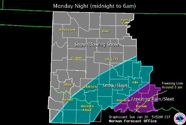
WITH THE COLD AIR DEEPENING FAIRLY QUICKLY... BELIEVE PERIODS OF
FREEZING RAIN WILL BE RELATIVELY SHORT (for the metro)... WITH THE SOUTH
CENTRAL AND SOUTHEAST SEEING THE MOST FREEZING RAIN AND SLEET.
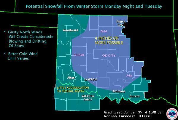
SOME AREAS IN THE WATCH AREA COULD SEE 4 OR MORE INCHES OF SNOWFALL...
ALTHOUGH PINPOINTING HEAVIEST SNOW AREAS IS DIFFICULT ATTM. STRONG
NORTH WINDS AND FALLING TEMPERATURES LATE MONDAY NIGHT INTO
TUESDAY WILL CREATE BITTERLY COLD WIND CHILLS ALONG WITH THE
POSSIBILITY OF BLOWING/DRIFTING SNOW. THE WINTER PRECIPITATION IS
EXPECTED TO TAPER OFF FAIRLY QUICKLY BY TUESDAY AFTERNOON AS THE
UPPER SYSTEM STARTS TO SHIFT TO THE EAST.
THE COLD WEATHER... AND SUBFREEZING TEMPERATURES... ARE EXPECTED
TO LINGER INTO THURSDAY ACROSS MUCH OF THE AREA.
Participating Member
Looks good to me...Would rather have 4 or 5 inches of snow than a quarter inch of ice...I would also think the high winds will help road condition wise even though we might not be able to see a damn thing
David
Thanks for getting the updates from Norman posted Thunder.
NAM and GFS this morning still hate each other. HPC advice is that GFS is favored right now for the most part. GFS is tending to favor a more rain to freezing rain to a very short period of snow. This solution we could see up to a half inch of rain and freezing rain before transitioning to snow where we may see 1 to 3 inches tops. NAM on the other hand is more aggressive and has the cold air in place earlier. It goes for mostly snow with a swatch of 12-18 inches for most of Central & NE Oklahoma with an area inside that of 18 to 24 inches from OKC to just north of Tulsa.
The system is on shore now, so going to see how the models react later today once they have all the data fully processed.
Participating Member
2 feet of snow...That sounds realistic with a fast moving storm
If we get 2 feet of snow, it is going to look like a galactic pillow fight.
David
If it would ever happen, we would be shut in for a week.
It won't happen. I know this because we had the house wired for a generator, got a generator, and even have gasoline at the ready. No worries. I have paid for our insurance, at least for this part of town. <vbg>
Poster
I'm favoring the NAM. haha
Is the system showing any signs of slowing down when it gets here?
And the latest from KOCO at http://kocoweatherblog.wordpress.com...-think-i-know/
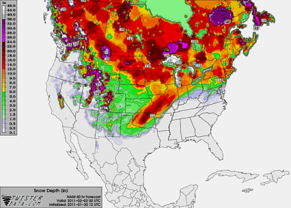
I like this NAM graphic. heh
There are currently 1 users browsing this thread. (0 members and 1 guests)
 Posting Permissions

 Reply With Quote
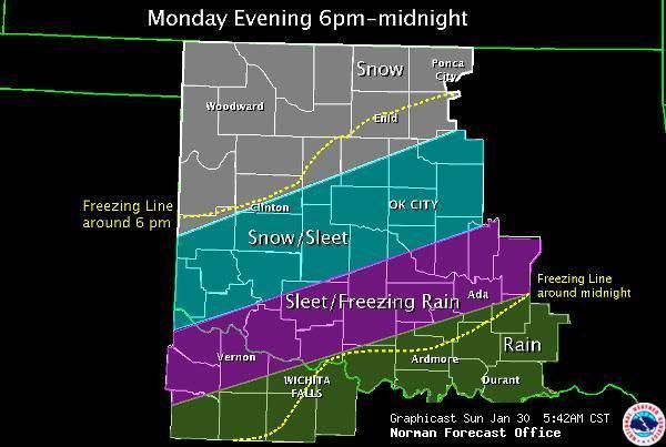
Bookmarks