Widgets Magazine
Page 58 of 383 FirstFirst ... 85354555657585960616263108158 ... LastLast
Results 1,426 to 1,450 of 9575

Thread: Streetcar

  1. #1426

    Default Re: The Modern Streetcar and Commuter Transit Project in MAPS 3 Progresses

    Quote Originally Posted by Kerry View Post
    The system I posted goes within 2 blocks of every point of interest in downtown OKC. Name one I missed. It also hists 6 of the 8 hotels in the downtown OKC area and allows for ample TOD. Sure you can cut the line in HH and Mesta Park and go to OU Medical but who is going to ride it after 6PM? Are the people stating in the downtown hotels going to be venturing to OU medical at 9PM? I don't think so. If you try to go south out of downtown you run out of track before you get anywhere.
    Not every point of interest must be served. This is an example of trying to please everyone and helping no one at the same time. Perhaps a system that serves every "point of interest" downtown is the worst possible thing we could have.

    And I see nothing wrong with a streetcar terminus in the middle of a residential area, it's just that you have to be selective about which. Walker is not it, Walker is pretty low-density for the most part. Robinson and Shartel both would be much more conducive to streetcar, especially Robinson. It's just that having the terminus around 18th and Walker makes about as much sense as making sure the jail area is well-served.

    Oh and one important downtown "point of interest" you forgot to serve is the Ken Boyer Bail Bonds at 5th and Shartel. So back to the drawing board for you Kerry. Lol

  2. #1427

    Default Re: The Modern Streetcar and Commuter Transit Project in MAPS 3 Progresses

    Quote Originally Posted by Urban Pioneer View Post
    I've migrated towards the other approach. You give them the absolute best core system you can within the budget, and a full blown system plan.

    Give them options that they can't go wrong with.

    Regarding neighborhoods- neighborhood centers make excellent terminuses. There
    is nothing wrong with streetcar going through residential part of the way.
    So the plan is to still propose a downtown circulator first but show later expansion options to other parts of town in the same proposal?

  3. #1428

    Default Re: The Modern Streetcar and Commuter Transit Project in MAPS 3 Progresses

    There has to be a "core" system irregardless of political rhetoric. We have to give council good choices as to how to "stretch" it to other meaningful urban centers in the context of a master plan. Today alone, some of us identified four viable destinations within the estimated budget that are truly outside of downtown. We evaluated street lenghts, sizes, expansion capabilities.

  4. #1429

    Default Re: The Modern Streetcar and Commuter Transit Project in MAPS 3 Progresses

    Is there any indication about how much time it’s going to take to get from a central hub out to the far end of the system?


    In the coming years as a trolley system gets interconnected to other types of transit transportation like light rail, commuter rail and buses, time / speed to high destination stops are critical factors for any successful transit system.

  5. #1430

    Default Re: The Modern Streetcar and Commuter Transit Project in MAPS 3 Progresses

    I agree with ou48a, but I don't think we're anywhere close to that mattering yet. In NYC commute time is really important--areas of Brooklyn that are further from Midtown Manhattan like Brighton Beach are where you can find good deals on good apartments. That's also why some areas just across the river from Midtown like Astoria are suddenly becoming extremely popular right now, because it's only a 15 min commute on the subway versus a 45 minute commute from Brighton Beach.

    Quote Originally Posted by Urban Pioneer View Post
    There has to be a "core" system irregardless of political rhetoric. We have to give council good choices as to how to "stretch" it to other meaningful urban centers in the context of a master plan. Today alone, some of us identified four viable destinations within the estimated budget that are truly outside of downtown. We evaluated street lenghts, sizes, expansion capabilities.
    So the initial starter system will include one of either Plaza/Paseo/Uptown/etc?

  6. #1431

    Default Re: The Modern Streetcar and Commuter Transit Project in MAPS 3 Progresses

    Quote Originally Posted by Tier2City View Post
    I would very much like to see your later phases.
    I can't post a picture of the total route system because at that scale it is unreadable so here is a text description.

    Yellow Line:
    My Yellow line extends north out of Heritage Hills, crossed 23rd and ends at NE36 and N. Dewy Ave. Going south out of downtown the yellow line goes along EKG to the new blvd, turns west, and then south at Robinson. It travels south and runs thru Capitol Hill along SW25th. At Walker it turns south again and continues to SW29th where it turns west to S. Western. I currently have it terminating at SW Medical Center.

    Red and Black Lines:
    Both the red and black lines go north out of Deep Deuce and turn right on Harrison on their way to Lincoln. On Lincoln they turn north and got the state capitol. The black line terminates at the capitol. This allows the black to connect all government offices (County, State, Local). The red line continues north on Lincoln to NE50th where it turns east and goes to Remington Park.

    To the west my red line continues past St. Anthony, to North Penn. It goes 3 blocks north on Penn to NW12. It follows the original streetcar tracks on NW12 and north up Drexel. It terminates at N23rd.

    Blue Line:
    My blue line goes south from Santa Fe to the new blvd, turns west and follows the new blvd until it meets Exchange. It takes exchange to StockYard City and turns south on Agnew. It then goes south to SW29th and goes east 3 blocks to South Penn. It goes south on Penn and terminates at I-240.

    Green Line:
    My green line follows the same route from Santa Fe to St Anthony as the red line and then turns north on Classen. It goes all the way north on Classen and terminates at I-44 just south of Wal-Mart. I then created a bus connector that serves local shopping and major employers (Chesapeake, Mid First, Classen Curve, Belle Isle Station, Penn Square, 50 Penn Place).

    Purple Line:
    The purple line is the 23rd street connector. It goes from Drexel/NW23rd to the State Capitol and connects with the green line at Classen, the yellow line at North Walker, and the black and red lines at the state capitol. Transfer to this train is free to anyone getting on or off the Green, Yellow, Black, and Red lines

    Pink Line:
    The pink line is the SW29th St connector. It goes from May Ave/29th St to Shields and connects with the Blue line at Agnew/Penn (uses the same track for 3 blocks) and the yellow line at S Western and S Walker (uses the same track for 4 blocks)

    My total system has 7 lines. 5 go to Santa Fe Station and two are cross-town connectors (one on the north side and one on the south side). I am also thinking of putting in an Orange line that follows along Shields and connects to the Boathouse district but I am still looking at possible routes. I was also thinking about extending the black line all the way to the Fairgrounds via General Pershing Way.

  7. #1432

    Default Re: The Modern Streetcar and Commuter Transit Project in MAPS 3 Progresses

    Quote Originally Posted by Spartan View Post
    So the initial starter system will include one of either Plaza/Paseo/Uptown/etc?
    Those would be strong candidates along with some other likely possibilities such as the Capitol. We would need good realistic ways of getting there – how would you do that and then how would you rank the options? And how would the “Phase 1b” then be extended on in Phase 2 or Phase 3?

    I think we can do a solid Midtown – Downtown – Bricktown/Hub/Convention Center/Park core couplet with 4 miles. (FWIW, I feel very strongly that the Hub, Park and Convention Center must definitely be reached by this core couplet.) That would leave 2 miles to work with.

    It then becomes very likely that we would need to use single track in some areas to get out of Downtown/Midtown. That would be similar to the short stretches in Portland along SW Montgomery and SW 4th plus the long stretch from SW Moody and SW River Parkway to SW Moody and SW Gibbs. (Admittedly, part of the latter segment is along an old railroad bed). Another situation to consider would be from S 21st and Pacific to the Tacoma Dome station in Tacoma.

    There are clearly streets that would lend themselves to this approach, such as Robinson from 13th to 23rd. Another factor to think about is as the system expands could such streets be doubled tracked or a couplet added to handle the increased frequency as the system expands in Phase 2?

  8. #1433

    Default Re: The Modern Streetcar and Commuter Transit Project in MAPS 3 Progresses

    Quote Originally Posted by Tier2City View Post
    Those would be strong candidates along with some other likely possibilities such as the Capitol. We would need good realistic ways of getting there – how would you do that and then how would you rank the options? And how would the “Phase 1b” then be extended on in Phase 2 or Phase 3?

    I think we can do a solid Midtown – Downtown – Bricktown/Hub/Convention Center/Park core couplet with 4 miles. (FWIW, I feel very strongly that the Hub, Park and Convention Center must definitely be reached by this core couplet.) That would leave 2 miles to work with.

    It then becomes very likely that we would need to use single track in some areas to get out of Downtown/Midtown. That would be similar to the short stretches in Portland along SW Montgomery and SW 4th plus the long stretch from SW Moody and SW River Parkway to SW Moody and SW Gibbs. (Admittedly, part of the latter segment is along an old railroad bed). Another situation to consider would be from S 21st and Pacific to the Tacoma Dome station in Tacoma.

    There are clearly streets that would lend themselves to this approach, such as Robinson from 13th to 23rd. Another factor to think about is as the system expands could such streets be doubled tracked or a couplet added to handle the increased frequency as the system expands in Phase 2?
    Right, I understand all that. Not saying I'm ahead of anyone's thinking, it's just that I have paid attention to absolutely everything being said by the people serving on AA, the subcommittee, and in other streetcar capacities and I think I have a good feel for what's going on and what considerations must be made for certain things. Where I'm coming from is really just wanting to know definitively if this is going to be just downtown or stretch out to other areas. We all know it will 15 years from now, that's not up for debate, and we all want that to be the case. I am just getting a very mixed, convoluted message about what the approach of the starter system is going to be.

    Is Pete White's position going to be a deal-changer for real?

  9. #1434

    Default Re: The Modern Streetcar and Commuter Transit Project in MAPS 3 Progresses

    Oklahoma City leaders considering alternatives to downtown streetcar
    At least one city council member would like to see some of the money included in MAPS 3 go to city buses.
    BY BRYAN DEAN, bdean@opubco.com
    The Oklahoman
    Published: January 10, 2011

    More than a year after voters approved MAPS 3, city leaders are split on what to do with one of the biggest pieces of the proposal — $130 million for a downtown streetcar and transit hub.

    In recent weeks, Ward 4 Councilman Pete White has come out against the plan for a 5- or 6-mile streetcar system that was pitched to voters during the MAPS 3 campaign.

    Such a streetcar would run on rails and would cost at least $20 million a mile to build. White said he wants to keep the promise to voters of building a downtown circulator, but he would like the city to look at cheaper options such as an enhanced version of the downtown trolley system already in place, which uses modified city buses.

    The bulk of the money for transit included in MAPS 3 then could be used to improve city bus service or build a light rail line that would serve many more people, White said.

    “I drive by a bus stop every day that is not sheltered, and there are eight people standing there almost every day,” White said. “We don't have a conscience about that.”

    Supporters see the streetcar as a potential economic development tool. They say a bus line can be changed. But a streetcar on rails is permanent and sends a sign to potential business owners that they can bank on the traffic that comes with it.

    Serving downtown

    The streetcar mostly would serve those who live and work downtown. It could also convince more downtown workers to move into expanding residential developments, supporters say.

    Jeff Bezdek, a downtown resident who has fought for a streetcar system since before MAPS 3 was proposed, said people were promised more than a rubber-tire trolley system like the one already in place downtown. He also said MAPS isn't the way to pay for buses, which have a low capital cost but high maintenance and operating costs.

    “MAPS is not designed to handle ongoing operational costs,” Bezdek said. “We build things that are permanent, that are meaningful.”

    Bezdek said a modern streetcar running on rails would be the kind of top-of-the-line project that people have come to expect from MAPS.

    Mayor Mick Cornett said there is no short-term solution to the problems with the city's bus system. Most people who ride a bus have to connect through downtown, and buses don't run frequently enough to make them practical.

    Rider's complaints

    Tramale Jones, of Oklahoma City, rides the bus every day. He said the city needs to run buses 24 hours a day like most major cities and should run routes frequently enough that people would see them as an alternative to driving themselves.

    “On the weekend they run most routes every hour,” Jones said. “It takes you three hours to get there and back.”

    Keyawanna Hawkins rides the bus every other day. She said the long wait is her biggest complaint.

    “It would be 10 times faster if I had a car,” Jones said.

    Cornett said those complaints are valid, but there is no easy way to address them.

    “I looked very long and hard at finding a way to enhance our bus system in MAPS 3,” Cornett said. “But without a permanent funding source, we just couldn't make the funding work. I would love to find a way to solve the issue. I just don't think we are close to that day”

    Many believe the streetcar would serve mostly young professionals capable of walking around downtown.

    Recalling a recent budget fight to preserve two enhanced bus routes that were on the chopping block last summer, White said he'd like to see those who rely most on public transit — the poor, handicapped and elderly — get at least a piece of the MAPS pie.

    “We had to fight for $40,000 to get enough money for buses for people who need those buses to get back and forth to work, and it was like pulling teeth to get it done,” White said. “Nobody speaks for those people. And yet we are willing to drop $120 million on a system that will make it easy for people to get from point A to point B a block away.”

    http://newsok.com/oklahoma-city-lead...#ixzz1AdxJQsp4

  10. #1435

    Default Re: The Modern Streetcar and Commuter Transit Project in MAPS 3 Progresses

    Pete White is about as clueless as they come. If he thinks $130 million is a lot for 6 miles of streetcar track he is going to soil himself over the price of lightrail which is over $70 million per mile. 6 miles of that will cost $420 million and won't serve near as many people.

  11. #1436

    Default Re: The Modern Streetcar and Commuter Transit Project in MAPS 3 Progresses

    Hopefully all of the Pete White discussion will lead to an overhaul of our city transportation as a whole, buses, trolleys, bus stops, river boats, etc.

    Where was Mr. White with the Okla River boats funding?

  12. #1437

    Default Re: The Modern Streetcar and Commuter Transit Project in MAPS 3 Progresses

    Quote Originally Posted by Spartan View Post
    Right, I understand all that. Not saying I'm ahead of anyone's thinking, it's just that I have paid attention to absolutely everything being said by the people serving on AA, the subcommittee, and in other streetcar capacities and I think I have a good feel for what's going on and what considerations must be made for certain things. Where I'm coming from is really just wanting to know definitively if this is going to be just downtown or stretch out to other areas. We all know it will 15 years from now, that's not up for debate, and we all want that to be the case. I am just getting a very mixed, convoluted message about what the approach of the starter system is going to be.

    Is Pete White's position going to be a deal-changer for real?
    I don't know what you mean by a mixed, convoluted message.

    The message is clear. You have to have a solid core system, i/e the "transit mall." Enough key people do not want to see a circular downtown perimeter line as they equate that to a "tourist ride." They want to see the millage "stretched" out connecting some "meaningful" place outside of downtown.

    I am not talking about the committee... I am talking about the sentiment of several key people on council.

    Give them a good core system. Give them good, meaningful urban destinations outside of downtown, and provide a solid master plan with recommended phases. Finally, identify a solid "federal funding" objective that can be pursued.

  13. #1438

    Default Re: The Modern Streetcar and Commuter Transit Project in MAPS 3 Progresses

    Quote Originally Posted by okclee View Post
    Hopefully all of the Pete White discussion will lead to an overhaul of our city transportation as a whole, buses, trolleys, bus stops, river boats, etc.

    Where was Mr. White with the Okla River boats funding?
    He supported and voted for it, "of cousre, that was before he was against it".

  14. #1439

    Default Re: The Modern Streetcar and Commuter Transit Project in MAPS 3 Progresses

    In light of Pete White's comment, I don't feel so good anymore. This must be how a NASCAR driver feels when he goes from 1st place to 2nd places and finds out one of his pit crew guys is putting water in the gasoline.

    http://www.sltrib.com/sltrib/home/50...llion.html.csp

    http://cleantechnica.com/2011/01/07/...e-city-speech/

  15. #1440

    Default Re: The Modern Streetcar and Commuter Transit Project in MAPS 3 Progresses

    "Becker’s next goal is to bring streetcars to downtown Salt Lake City, which it has already started getting federal funding for, recently receiving half a million dollars for this project."

    Not that half a million dollars is a lot of purchasing power, but it's interesting that federal money is available for a downtown streetcar.

  16. #1441

    Default Re: The Modern Streetcar and Commuter Transit Project in MAPS 3 Progresses

    Quote Originally Posted by betts View Post
    "Becker’s next goal is to bring streetcars to downtown Salt Lake City, which it has already started getting federal funding for, recently receiving half a million dollars for this project."

    Not that half a million dollars is a lot of purchasing power, but it's interesting that federal money is available for a downtown streetcar.
    Their $55 million Sugar House line just got a check from the Feds for $26 million in October.

  17. Default Re: The Modern Streetcar and Commuter Transit Project in MAPS 3 Progresses

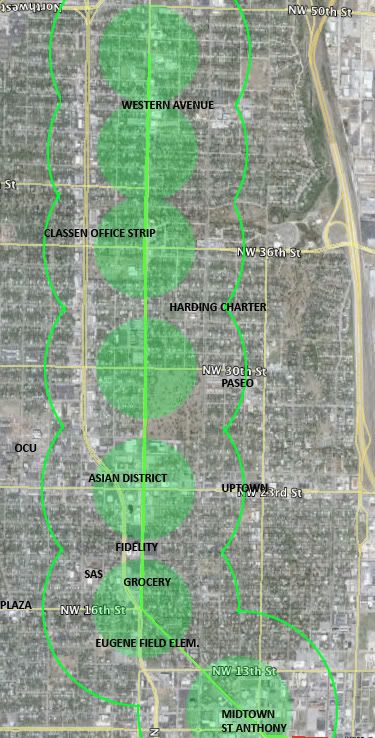
    I also hesitate to add to map after map after map, but when I was playing with some routes I noticed that Western Avenue might be a great candidate. It is a quiet non-arterial street that is right in the middle of a lot of things, with great expansion potential to the north all the way to Chesapeake. Maybe a 2-mile single track along Classen Dr and Western to 30th for the first phase. This shows potential up to I-44. I included 5- and 10-minute walking radii to show how close it gets to a lot of major destinations. I used 700 meters (.43 mi) for a 10-minute walk, which is actually a little less than the standard estimate of 800 meters (.5 mi).


    This route would easily place a LOT of important institutions, neighborhoods, and businesses within a 10-15 minute walk, or a 5-minute bike ride, including the Paseo, Plaza, Asian Dist, and Uptown areas. Major TOD potential with at least 3.5 blocks of surface parking on Western between 23rd and 18th. Also plenty of empty land near Western between 23rd and Fairlawn Cemetery.

  18. #1443

    Default Re: The Modern Streetcar and Commuter Transit Project in MAPS 3 Progresses

    I was actually thinking about Western Avenue and thought it had some incredible potential as a couplet paired with Classen. There's only ONE block in between the two, and that block between Western and Classen is perfect for TOD because it's not historically protected or significant, in fact it's kind of slummy compared to surrounding areas. Like a Robinson/Broadway transit mall, the couplet routes would be on the inside of the transit mall, so going north up Classen and south down Western so you don't have to cross 6 lanes of Classen Blvd.

    Alternatively there is some incredible potential with Classen's median. Also one little factoid to consider is that similarly to downtown, there is a streetscape coming to Western and that could hurt or benefit streetcar. That streetscape will need to be transit-friendly, or perhaps even offers opportunities for collaboration. I still think 23rd should be the streetscape spine for the north side. In a 30-year system we might even look at separating the northside, downtown, and southside systems and giving each of them their own hub and the northside's hub could be right at 23rd/Classen (the CVS or Walgreens) could be an opportunity worth looking at, because of the potential of many different north side lines to all come together right there at 23rd/Western/Classen and because of what an underdeveloped intersection that is, the amazing TOD potential.

  19. #1444

    Default Re: The Modern Streetcar and Commuter Transit Project in MAPS 3 Progresses

    How do people feel about the Capitol as an "anchor?"

  20. #1445

    Default Re: The Modern Streetcar and Commuter Transit Project in MAPS 3 Progresses

    Quote Originally Posted by Urban Pioneer View Post
    How do people feel about the Capitol as an "anchor?"
    Should be yes.

  21. #1446

    Default Re: The Modern Streetcar and Commuter Transit Project in MAPS 3 Progresses

    Quote Originally Posted by Urban Pioneer View Post
    How do people feel about the Capitol as an "anchor?"
    As an "anchor"? I don't like that. Lincoln Blvd, especially north of the capitol, is the hinterlands. It will be difficult to get TOD potential along Lincoln because between the medical district and the capitol is a historically protected area and everything else is owned by the state. Furthermore the capitol is just too isolated from where the bulk of potential streetcar areas in OKC are that it makes no sense. I also think if the state workers are going to get a route catering to them then the state needs to pay for it. I know Skip Kelly isn't satisfied unless alllll of the streetcar is in his district, but he needs to be okay with just Deep Deuce being included because even that is looking unlikely now, and then he needs to help out in trying to get streetcar funding from the feds if we're going to make a government line go up Lincoln and deeper into NE OKC.

    For me, especially if the people of OKC are paying for all of it, that just doesn't do anything. The priority of areas that the streetcar should serve are as follows in my mind: 1 Downtown (including BT, Arts, DD, MT), 2 Uptown, 3 Capitol Hill (with another city vote), 4 Plaza, 5 Paseo, 6 Medical District/Capitol (with fed/state funding), 7 Western Avenue, 8 extend 23rd line beyond Uptown (serve OCU, connect other lines), 9 Stockyards City and more southside (with another city vote)

  22. #1447

    Default Re: The Modern Streetcar and Commuter Transit Project in MAPS 3 Progresses

    Quote Originally Posted by Urban Pioneer View Post
    How do people feel about the Capitol as an "anchor?"
    You are joking Right?!?!

    I feel that is a huge waste for an anchor!

    I will be very disappointed if the streetcar goes anywhere near Lincoln in the phase 1 or 2 or 3!!!

    Take a look at the actual work schedule of the people at the Capitol and see how little they would actually use the streetcar. The same goes for the Health Science area, many people in this area but very few have the luxury to move around much using a streetcar.

    Another question would be, How many of our state politicians would actually vote for a streetcar or help Okc receive federal funding? I would bet very few, most would have turned down streetcar for Okc!

    If the Capitol wants to ride let them pitch in and gather additional federal funding to help pay for a stop nearby.

  23. #1448

    Default Re: The Modern Streetcar and Commuter Transit Project in MAPS 3 Progresses

    Not against an "anchor" line going to the Capital per se, but as Spartan and even the Mayor suggested, the State should probably be involved in the cost (just as the cost to various burbs should be shared by those burbs). The costs of a line going to Tinker should be shared by the Feds (but then again, probably end up with a county bond issue paying for it).

  24. #1449

    Default Re: The Modern Streetcar and Commuter Transit Project in MAPS 3 Progresses

    Quote Originally Posted by okclee View Post
    You are joking Right?!?!

    I feel that is a huge waste for an anchor!

    I will be very disappointed if the streetcar goes anywhere near Lincoln in the phase 1 or 2 or 3!!!

    Take a look at the actual work schedule of the people at the Capitol and see how little they would actually use the streetcar. The same goes for the Health Science area, many people in this area but very few have the luxury to move around much using a streetcar.

    Another question would be, How many of our state politicians would actually vote for a streetcar or help Okc receive federal funding? I would bet very few, most would have turned down streetcar for Okc!

    If the Capitol wants to ride let them pitch in and gather additional federal funding to help pay for a stop nearby.
    Interesting reaction. lol I do think that it is appropriate to ask though. Philosophically, I agree about the funding. Technically, we do know that there are a great many people who travel there for different reasons. The thing that I find fascinating about it, is that it sits in the middle of essentially a highway interchange. It is a completely isolated place (from a pedestrian point of view). It is nearly impossible to walk out of the "ring" unless you walk due south on Lincoln.

  25. #1450

    Default Re: The Modern Streetcar and Commuter Transit Project in MAPS 3 Progresses

    First let me say that is too bad the Capitol was built so far away from downtown to begin with. I think anything that connects the Capitol Complex with downtown is a good thing. To my knowledge Oklahoma is the only state where the capitol is not in or adjacent to the center of business.

Thread Information

Users Browsing this Thread

There are currently 3 users browsing this thread. (0 members and 3 guests)

Similar Threads

  1. OKC mass transit announcement!!
    By metro in forum General Civic Issues
    Replies: 444
    Last Post: 05-05-2010, 11:56 AM
  2. The Portland Streetcar: A case in point
    By betts in forum General Civic Issues
    Replies: 31
    Last Post: 12-07-2009, 09:34 AM
  3. MAPS 3 News Compendium
    By Doug Loudenback in forum General Civic Issues
    Replies: 108
    Last Post: 12-05-2009, 10:55 AM
  4. New info on MAPS 3
    By metro in forum General Civic Issues
    Replies: 533
    Last Post: 12-02-2009, 10:56 AM
  5. MAPS 3 Press release
    By ChowRunner in forum General Civic Issues
    Replies: 167
    Last Post: 10-03-2009, 04:58 AM

Bookmarks

Posting Permissions

  • You may not post new threads
  • You may not post replies
  • You may not post attachments
  • You may not edit your posts
  •  
Single Sign On provided by vBSSO