

Do you "represent the city"?Originally Posted by Urban Pioneer


 Participating Member

Do you "represent the city"?
Participating Member

I represent MAPS 3 transit and Regional Transit Dialogue as a citizen and campaigner.
Participating Member
It is my personal guess from what I have heard that the existing Cox Center will be around for a while. Also, it seems that the powers that be like the extra square feet that it would provide to a new convention district. It has also been attractive in simultaneous sporting events such as Big 12 basketball.
The brainstorming is great but it might be more targeted if we bantered about the area between 2nd (Deep Deuce) North, EK Gayord (West), Bricktown (East), and just South of the proposed new Boulevard (South).
At the existing BSF tracks the boulevard is slated to be depressed and go under such as Reno does now.
How do people feel about the new boulevard as it pertains to transit?
Participating Member
I think the boulevard, as far as cars are concerned, should be for low volume traffic. The focus of the boulevard should be the median, rather than the street. I, personally, would love to see the streetcar run along the boulevard, if it's a reasonable location for part of the line, ala the St. Charles streetcar. It could still be attractively landscaped, and have sidewalks for strolling, as I think it should basically be an extension of the Central Park/Myriad Gardens system downtown.
Participating Member
One interesting element of the boulevard as it is described in the Fixed Guideway Study is how it could potentially provide a dedicated lane and direct access to the new I-40 for BRT (Bus Rapid Transit). The FGS shows BRT servicing some Western cooridoors that would directly interface to the streetcar at the new hub.
The thing with BRT is that it may or may not work in OKC, and realistically it comes several years after streetcar is able to be successful. If we don't improve the perception and ridership of public transit, BRT goes out the window because it's basically a glorified bus system which has been proven ineffective in attracting riders in OKC.
Participating Member
I totally agree. But in a broader discussion about making sure that the "hub" is designed for the future, it is an element that should be factored.
The other aspect about making space allocations for BRT is that it can be converted to true Light Rail technology in the future.
In the FGS, lines go out towards Yukon, Airport, and up Northwest Expressway.
Participating Member
Um, the election is over...
Anyway, The potential boulevard (if ODOT gets its act together) would be a great place for the streetcar and/or canal extension.
Participating Member
But how far out do you design a hub? There has to be compromise here regarding what you can afford and what you plan to offer in the next 20 years. I highly doubt all the lines (CRT or BRT) will be built in that time frame. Let's not get carried away with delusions of grandeur before we've even laid down the first track. Design a hub that is expandable. It doesn't need 12 platforms and 20 bus turnouts at first, just room for them when funds become available and ridership deems it necessary.
Also, is the AA even considering the Boulevard for an alignment? I don't see how it can when there is no foreseeable funding.
VIP Member

Oklahoma Traffic Count Information System County/Oklahoma City 06&year=2009
Traffic Counts (2004):
Shields (at Oklahoma River): 11,433
Robinson (at Oklahoma River): 6,364
Walker (at Oklahoma River): 8,910
Western (at Oklahoma River): 14,090
Pennsylvania (at Oklahoma River): 10,354
Exchange (at Oklahoma River): 4,806
Byers (at Oklahoma River): 4,104
I-35 (at Oklahoma River): 125,400
Result, if traffic seems lighter on Shields it is because it can handle a lot more traffic. It is the second busiest Oklahoma River crossing outside of the interstate system. When Shields get a little farther south the traffic count goes up to 23,379. South of I-240 the traffic count on Shilds go up again to 27,149. Shields is the busiest road in South OKC.
It would be interesting to see the latest numbers now that the Thunder are playing 42 games a year in downtown, one block off of Shields.
Participating Member
Regarding traffic counts: I found this cool link on ACOG's site. You can look at traffic counts all over the metro.
link: http://www.acogok.org/Programs_and_S...TrafficCounts/
FYI.
VIP Member
Thanks this was fun- Lindsey St in Norman (1 lane each direction + center turn lane) carries about twice as much traffic as EK Gaylord!
Participating Member
Thanks for posting this.
Do you know why it would be interesting to get more recent numbers? Not because of the Thunder, but because half of those bridges are closed right now and everyone used Walker to get across the river.
You didn't mention how much busier Western is, and Shields is not the busiest road in S OKC..Western is, by far..
VIP Member
Spartan - the reason I would like to see more current numbers is because the most recent numbers are 5 years old (6 years old in about 4 hours). Downtown OKC has changed in the last 5 years.
Participating Member
Spartan.... those are numbers for traffic at the river... it's busier on shields south of the river. Western and Penn are the only ones closed right now.
VIP Member
So we should close all bridges except Western then??
Don't Edmond My Downtown
Hardly, I just don't think we need ten thousand bridges with a 2.5 mile stretch of the river. It kind of defeats the psychological understanding of a riverside. There are no special "river crossings" because everything goes across. And we especially don't need to endeavor to keep more of these bridges open.
The reason we got on this tangent in the first place is because someone argued that, "Oh noooo, we better not do anything that could risk closing off E.K. Gaylord, without that, the southside has no way to get downtown..."
I was just pointing out what a retarded and braindead response that is. No, I wouldn't argue for closing all of them. That would be pointless of me. I am not even going to say that we should go out of the way to close some..just saying, if the opportunity comes up we shouldn't avoid making a good move in downtown for risk that it might jeopardize keeping all of these bridges open. I'm just pointing out that it might not be so bad if we lose a bridge or two, especially EKG.
All sensationalism aside..
VIP Member
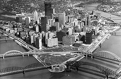
Thought you guys might like to see all the bridges that ruined the Pittsburgh waterfront.

Pittsburgh HAS had to put a lot of focus on reinvigorating their waterfronts. They got the Monongahela waterfront back to life and they have some plans that they're working on atm to revitalize the Allegheny side of downtown. I would argue though that Pittsburgh's amazing terrain lends itself naturally to focusing more on the river valleys, than OKC's flat terrain. The challenge is more on us than it is them.
Also these bridges with Pittsburgh aren't all highways that don't stop for a mile in each direction. All of OKC's Oklahoma River bridges for the most part, traffic doesn't stop until SW 25th on the south and like SW 4th on the north -- so that's basically two miles where you just keep going and going and the objective is to get across to the other side. Nobody drives to the Oklahoma River riverfront, you just drive PAST it. It's little more integral a part of the urban environment than a railroad underpass for that matter.
If we really want to fix the Oklahoma River we're going to have to let its riverfront become more of a physical boundary between north and south, that way the city can come up to the river from the north AND the south. Usually I dislike having a million street lights everywhere, but somehow you need to get the traffic to stop on the north side of the river right before traffic goes over the bridge.
And then the ecological issues..Something has to be done about the repressive gray asphalt that repeals any interest anyone would have in going near the water's edge--it just looks like some kind of toxic drainage ditch that the gray asphalt is telling people not to go near (which it really isn't, if we can just keep the Stockyards waste from getting dumped in the river). And the riverfront needs to be densely wooded, or at least around the bridges. 10 years when the trees mature you'll have the added benefit of not being able to see on the horizon practically, which shouldn't be possible in the middle of a city unless you're on top of a tall building. If only the immediately surrounding few hundred feet is visible on the human scale then you'll have more of a sense of place along the river I think. As it is the area is too open and expansive.
These are just things that can be done to improve the impact and recognition that yet, we do actually have a waterfront by downtown OKC, and that's how the river crossings play a big role in that. Stop having these half dozen pseudo highways that cross the river in too many different places, either a roadway is a "street" or it is a "road" -- and good cities are made of good streets. Without that psychological recognition that the waterfront exists, obviously the Oklahoma River won't ever develop as a part of the community aside from being a backyard for Olympic hopefuls to play in. This is how you bring infill development to a detached part of the city.
Participating Member
The planting of trees in the area and allowing portions to return to a wooded less accessible area sans trails and lighting is important in adding credibility to it being an actual waterfront rather than the widened concrete and stone rip rap lined canal that it began as. Granted it is making huge strides in such a short time, but the majority of it still resembles...an army corps of engineers project. And this is by no means a slam on them for with out them it would not be, however the way the sides of the waterway are constructed reads unnatural and to engineered. I know along the rowing venue this is probably helpful, but I am hopeful that with additional development that a softer approach might be used to blur the lines a bit more gracefully, and even widen some areas welcoming the water into spaces that actually provide some character to the waterway.
VIP Member
With the reduced curent flow can't we get rid of all the concrete and rocks on the banks?
Participating Member
Kerry,
I think it will cost a lot of money to remove the nasty rocks. It will have to be done as devlopments along the river remove the rocks one by one, or MAPS 4 or a bond are funded to remove them. They are not along the river upstream around Meridian and it is so much more peaceful and attractive.
VIP Member
Don't we have prisoners that are capable of turning big rocks into small rocks.
Participating Member
In an effort to bring this thread back to the topic of transportation developments in relation to the passage of MAPS III and its street car and intermodal Hub study, possibilities.
Has anyone been following the High Speed Rail proposals that the Feds are proposing and allocating 13 Billion for? The Proposal links a Line from San Antonio to Austin and on to Dallas and then from Dallas it splits and one line goes up to OKC and then on to Tulsa where the High speed portion terminates. The second line from Dallas heads through Texarcanna on up to Fort Smith, Arkansas. In addition to that there is an actual proposal by a French High Speed rail company that has presented a formal proposal to fund and build a similar line from San Antonio/Austin/Dallas with the trains due to run up to 220 MPH cutting the time from Dallas to SA down to 1hour 50 mins.
Please note the link to the Dallas Morning News and the actual proposal.
http://transportationblog.dallasnews...texas-hig.html
There are currently 7 users browsing this thread. (0 members and 7 guests)
 Posting Permissions

 Reply With Quote


Bookmarks