Widgets Magazine
Page 1 of 5 12345 LastLast
Results 1 to 25 of 118

Thread: Severe Weather Outlook - Sat 6/6 through Fri 6/12

  1. Default Severe Weather Outlook - Sat 6/6 through Fri 6/12

    I'm going to get an outlook done for the next week starting today, but will focus on the SPC stuff for the first few days and then go ahead and post my thoughts here in a few when I get some more time.

    Graphics - These will auto update on their own for that particular date/time. Period of this thread does start 6/6/09 but the graphics will continue to change to be of current time.


    NWS Norman Enhanced Page: NWS Norman, Oklahoma - Enhanced Weather Page

    State Webcams: Live Webcams - AnvilCrawlers

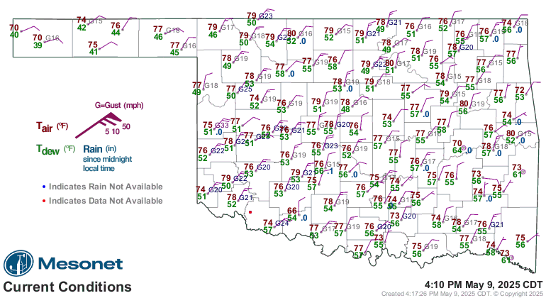
    Current Conditions: Current Conditions - AnvilCrawlers

    Model Forecasts: Model Forecasts - AnvilCrawlers

  2. Default Re: Severe Weather Outlook - Sat 6/6 through Fri 6/12

    Saturday 6/6 - Today
    Slight Risk for the Western 1/3rd of Oklahoma. Main risk is large hail and damaging winds. This threat could move into Central sections later as mostly a damaging wind threat from collapsing thunderstorms/heat bursts. Extremely electric storms are also likely, so if you are out on the lakes and such, be aware.

    SPC MA Sector for today covering Oklahoma: SPC Hourly Mesoscale Analysis Page

    Update for watch.


    URGENT - IMMEDIATE BROADCAST REQUESTED
    SEVERE THUNDERSTORM WATCH NUMBER 337
    NWS STORM PREDICTION CENTER NORMAN OK
    440 PM CDT SAT JUN 6 2009

    THE NWS STORM PREDICTION CENTER HAS ISSUED A
    SEVERE THUNDERSTORM WATCH FOR PORTIONS OF

    SOUTHWEST OKLAHOMA
    NORTHWEST TEXAS

    EFFECTIVE THIS SATURDAY AFTERNOON AND EVENING FROM 440 PM UNTIL
    1100 PM CDT.

    HAIL TO 2 INCHES IN DIAMETER...THUNDERSTORM WIND GUSTS TO 70
    MPH...AND DANGEROUS LIGHTNING ARE POSSIBLE IN THESE AREAS.

    THE SEVERE THUNDERSTORM WATCH AREA IS APPROXIMATELY ALONG AND 75
    STATUTE MILES NORTH AND SOUTH OF A LINE FROM 85 MILES SOUTHWEST
    OF CHILDRESS TEXAS TO 30 MILES SOUTHEAST OF FORT SILL OKLAHOMA.
    FOR A COMPLETE DEPICTION OF THE WATCH SEE THE ASSOCIATED WATCH
    OUTLINE UPDATE (WOUS64 KWNS WOU7).

    REMEMBER...A SEVERE THUNDERSTORM WATCH MEANS CONDITIONS ARE
    FAVORABLE FOR SEVERE THUNDERSTORMS IN AND CLOSE TO THE WATCH
    AREA. PERSONS IN THESE AREAS SHOULD BE ON THE LOOKOUT FOR
    THREATENING WEATHER CONDITIONS AND LISTEN FOR LATER STATEMENTS
    AND POSSIBLE WARNINGS. SEVERE THUNDERSTORMS CAN AND OCCASIONALLY
    DO PRODUCE TORNADOES.

    DISCUSSION...A CLUSTER OF HIGH-BASED THUNDERSTORMS IS DEVELOPING
    ACROSS NORTHWEST TX...WHERE HOT SURFACE TEMPERATURES HAVE HELPED TO
    INITIATE CONVECTION. THESE STORMS ARE LIKELY TO MAINTAIN INTENSITY
    AND TRACK/DEVELOP SLOWLY NORTHEASTWARD INTO SOUTHWEST OK DURING THE
    NEXT FEW HOURS WITH A RISK OF DAMAGING WINDS AND HAIL.

  3. Default Re: Severe Weather Outlook - Sat 6/6 through Fri 6/12

    There is some severe weather in the state, but nothing Metro impacting right now. Will post updates if things get closer.

  4. Default Re: Severe Weather Outlook - Sat 6/6 through Fri 6/12

    Overnight Early Monday Morning into the day on Monday...

    Scattered strong/severe storms are continuing to develop in the Central part of the state. Storms will have some severe hail but the biggest risk tonight is high wind. Collapsing storms have been producing 60-80mph winds throughout the night.

    SPC Discussion for Monday


    ...SRN PLAINS...
    A CAPPING INVERSION SHOULD BE IN PLACE MONDAY MORNING ACROSS MUCH OF
    THE SRN PLAINS. MODEL FORECASTS DEVELOP STRONG INSTABILITY FROM
    NORTH TX NEWD INTO NE OK WHERE SCATTERED THUNDERSTORMS DEVELOP
    MONDAY AFTERNOON. FORECAST SOUNDINGS AT 00Z SHOW 35 TO 40 KT OF 0-6
    KM SHEAR WITH STEEP MID-LEVEL LAPSE RATES. THIS COMBINED WITH STRONG
    INSTABILITY SHOULD BE SUFFICIENT FOR ISOLATED SUPERCELL DEVELOPMENT
    WITH VERY LARGE HAIL AND WIND DAMAGE POTENTIAL. A FEW STORMS MAY
    ALSO INITIATE FURTHER SOUTHWEST INTO WCNTRL TX WITH A POTENTIAL FOR
    HAIL AND/OR STRONG WIND GUSTS.

  5. Default Re: Severe Weather Outlook - Sat 6/6 through Fri 6/12

    Front has stalled out (for the most part) around the I-44 corridor...winds are north in The Village/Yukon and from the south in S OKC and Norman. Scattered development is occurring south and north of the Metro area. Area along (just slightly north) and south of the front remains very unstable today. Tornado risk is very slow, but hail and wind threat is moderate to high today with any storms that can form (cap is very strong). We are going to be in this period for the next week with isolated/scattered severe storms popping up (if they can break the cap). There also seems to be some indications we are moving into a more favorable setup for MCS/MCCs later in the week.

    Latest SPC thinking:

    ...CENTRAL OK NEWD INTO SWRN MO...
    STILL MAINTAINING SLIGHT RISK...THOUGH CAP IS HOLDING STRONG DUE TO INCREASED CUMULUS CLOUD DEVELOPMENT AND WEAK FORCING. STORMS LOOKING MORE UNLIKELY...BUT SHOULD A STORM DEVELOP...MLCAPES NEARING 4000 J/KG AND 30-40 KT DEEP LAYER SHEAR WOULD BE FAVORABLE FOR SUPERCELLS WITH HAIL/WIND DAMAGE.

  6. #6

    Default Re: Severe Weather Outlook - Sat 6/6 through Fri 6/12

    The NWS has mentioned the possibility of more heat bursts this evening across south central Oklahoma. There have been a few of these events over the last couple of weeks. Are they caused by the hot air "cap" aloft? I dont remember there ever being so many in so short of time frame. Looking forward to the weeks storms.


    Reported wind gusts the last 7 days.....mostly cause by or associated with heat bursts.

    Station Wind Gusts Date Time
    Washington 71 mph Jun 7 9:50 pm
    Washington 65 mph Jun 7 9:55 pm
    Woodward 63 mph Jun 6 2:45 am
    Slapout 63 mph Jun 6 2:05 am
    Slapout 62 mph Jun 6 1:25 am
    Stuart 60 mph Jun 3 1:35 am
    Acme 58 mph Jun 7 9:05 pm
    Acme 58 mph Jun 7 9:00 pm
    Woodward 58 mph Jun 7 4:35 pm
    Woodward 58 mph Jun 6 2:55 am
    Camargo 58 mph Jun 6 2:25 am
    Walters 58 mph Jun 3 1:20 am

  7. Default Re: Severe Weather Outlook - Sat 6/6 through Fri 6/12

    Yeah they knocked out power here in on the east side of Norman last night. Looking forward to it again...well not really. : )

    Watch for the extreme SW part of the state: Storm Prediction Center Severe Thunderstorm Watch 352


    DISCUSSION...RAPID THUNDERSTORM DEVELOPMENT IS EXPECTED ALONG A
    PRE-FRONTAL TROUGH ACROSS NW TX FROM 21-22Z...AND ADDITIONAL STORMS
    COULD FORM LATER THIS EVENING ALONG THE SYNOPTIC COLD FRONT FARTHER
    NE INTO SW OK. STRONG INSTABILITY AND A WEAKENING CAP ACROSS NW TX
    THROUGH DAYTIME HEATING/MIXING...AND THE APPROACH OF A SUBTLE
    MID-UPPER LEVEL SPEED MAX FROM SE NM...WILL SUPPORT AT LEAST
    SCATTERED SEVERE STORMS THROUGH EARLY TONIGHT. MLCAPE IN EXCESS OF
    3000 J/KG AND EFFECTIVE BULK SHEAR OF AT LEAST 40 KT WILL FAVOR
    SUPERCELLS CAPABLE OF PRODUCING VERY LARGE HAIL AND DAMAGING WINDS.
    RELATIVELY LARGE TEMPERATURE-DEW POINT SPREADS AND STORM
    MERGERS/UPSCALE GROWTH LATER THIS EVENING WILL ALSO SUPPORT AN
    INCREASING THREAT OF DAMAGING WINDS. ANY TORNADO THREAT WILL LIKELY
    BE LIMITED BY THE RELATIVELY HIGH LCL HEIGHTS AND SOMEWHAT MODEST
    LOW-LEVEL SHEAR.

  8. Default Re: Severe Weather Outlook - Sat 6/6 through Fri 6/12

    Scattered shows are developing just south of the front in Central Oklahoma now from Rush Springs/Chickasha over to Noble...Tribbey...Seminole...and Wetumka. Cell by Wektumka has some lightning with it now. Low level jet is going to be increasing tonight so development should continue from around this area and north. Main risks tonight will be hail with the strongest storms, but also very strong and potentially damaging winds with any collapsing storms.

  9. Default Re: Severe Weather Outlook - Sat 6/6 through Fri 6/12

    Don't see anything on the radar, Venture. You posted that an hour ago, so these storms must've been extremely short lived.

  10. Default Re: Severe Weather Outlook - Sat 6/6 through Fri 6/12

    Cap is extremely strong. Things should pick up later tonight to the SW and develop along and north of the front. Tricky forecast though with the cap.

  11. #11

    Default Re: Severe Weather Outlook - Sat 6/6 through Fri 6/12

    Hey Venture...this is very cool! Are you a weatherman/forcaster...or is this just a hobby?

    And lemme ask ya a question while you are on the line. About three weeks or so ago...there was a Thunderstorm system over OKC, around 3:00 in the morning. Then all the local TV Stations went into their alert mode...talking about the Thuderstorm collapsing and all the energy just rushing to the ground and dispersing along the ground. What was that called?

  12. Default Re: Severe Weather Outlook - Sat 6/6 through Fri 6/12

    Yep, I remember that.. something like 'heat bursts and collapsing storms' whatever it was, it knocked down all of our fences.
    " You've Been Thunder Struck ! "

  13. Default Re: Severe Weather Outlook - Sat 6/6 through Fri 6/12

    Went to school for it, but haven't done anything professionally.

    Heat Burst is the situation you are talking about. They happen this time of year when the storms collapse and the air completely rushes out from it. We had the situation last night that caused the severe winds westside pointed out.

  14. #14

    Default Re: Severe Weather Outlook - Sat 6/6 through Fri 6/12

    Venture,

    Thank you. All I know is that next day, or maybe a day later, the clouds in and around NW OKC were absolutely amazing...I was in utter awe because I had never seen anything like it before. The only way I can describe it is that it was like looking at an upside down bowl of gray cottage cheese.

    I tried posting the pics to KFOR but for some reason they didn't take.

    Next time I'll see if I can post them on here. I am sure you have seen plenty of clouds like the ones I saw that day.

  15. Default Re: Severe Weather Outlook - Sat 6/6 through Fri 6/12

    Those are called Mammatus...saw them as well.

    Mammatus cloud - Wikipedia, the free encyclopedia

  16. Default Re: Severe Weather Outlook - Sat 6/6 through Fri 6/12

    Heat Bursts are really fun! Ya get the thrill on the Jet Stream ride! Woooohoooooo!!!

    I'll try to explain it, possumfritter. When a storm die out, they naturally slow down gradually and all the air exit thru the outflow. Sometime, it is not the case. When the inflow suddenly stops, the storm collaspes. When that happen, all the air up in the storm comes crashing down, pulling the jet stream along with it. As the air rushes down, it heats up the air and rob it of humidity (becomes really dry).

    These kind of event can be damaging of hurricane strength winds at a constant speed for several hours.

  17. #17

    Default Re: Severe Weather Outlook - Sat 6/6 through Fri 6/12

    Thunder,

    That's the exact term KFOR used..."Hurricane Strenth Winds." It did get pert windy over here for a good bit, but I can guarandangtee ya, after surviving Hugo (South Carolina), those winds that morning weren't nuttin. LOL!!!

    But after what you folks went through with that May 3, 1999 tornado, I'll take a hurricane on the coast anytime!

  18. Default Re: Severe Weather Outlook - Sat 6/6 through Fri 6/12

    Outlook for Tuesday from SPC...OKC impacting comments are highlighted.

    DAY 1 CONVECTIVE OUTLOOK
    NWS STORM PREDICTION CENTER NORMAN OK
    0100 AM CDT TUE JUN 09 2009

    VALID 091200Z - 101200Z

    ...THERE IS A MDT RISK OF SVR TSTMS ACROSS PARTS OF KANSAS...

    ...THERE IS A SLGT RISK OF SVR TSTMS ACROSS PARTS OF THE CNTRL AND
    SRN PLAINS...OZARKS AND MID-MS VALLEY...


    ...THERE IS A SLGT RISK OF SVR TSTMS ACROSS PARTS OF NEW YORK...ERN
    PA...MD AND NJ...

    ...CNTRL AND SRN PLAINS...
    SOUTHWEST FLOW WILL BE IN PLACE ACROSS THE CNTRL PLAINS TODAY AS A
    60 TO 70 KT MID-LEVEL JET MAX APPROACHES THE REGION FROM THE
    SOUTHWEST. AT THE BEGINNING OF THE PERIOD...AN MCS WITH ELEVATED
    THUNDERSTORMS SHOULD BE ONGOING IN WRN KS WITH THIS CONVECTIVE
    SYSTEM MOVING EWD ACROSS CNTRL AND ERN KS BY EARLY AFTERNOON. IN THE
    WAKE OF THE MCS...STRONG DESTABILIZATION SHOULD OCCUR ALONG A MOIST
    AXIS WITH SFC DEWPOINTS IN THE LOWER 70S F EXTENDING NNWWD FROM
    CNTRL OK INTO WCNTRL KS. NAMKF FORECAST SOUNDINGS ALONG THIS
    CORRIDOR BY 00Z SHOW EXTREME INSTABILITY IN CNTRL OK WITH MLCAPE
    VALUES APPROACHING 5000 J/KG.
    FURTHER NORTHWEST...MLCAPE VALUES DROP
    INTO THE 3000 TO 4000 J/KG RANGE INTO NW KS. IN ADDITION...THE
    MID-LEVEL JET MAX SHOULD MOVE OVER THE INSTABILITY AXIS DURING THE
    LATE AFTERNOON AND EARLY EVENING CREATING STRONG VERTICAL SHEAR
    PROFILES WITH 0-6 KM SHEAR VALUES IN THE 50 TO 60 KT RANGE. THIS
    ENVIRONMENT WILL BE A VERY FAVORABLE RAPID SUPERCELL DEVELOPMENT
    ONCE SFC-BASED STORMS INITIATE JUST WEST OF THE MODERATE RISK AREA
    IN THE LATE AFTERNOON OR EARLY EVENING. MODEL FORECASTS ARE IN
    AGREEMENT ORGANIZING A CLUSTER OF INTENSE THUNDERSTORMS IN NRN KS
    AND DRIVING A WELL-DEVELOPED MCS EWD ACROSS NERN KS INTO NRN MO
    OVERNIGHT.

    CONCERNING THE SEVERE THREATS...A 30 TO 40 KT LOW-LEVEL JET WILL
    INCREASE FROM NRN OK INTO CNTRL KS DURING THE EARLY EVENING FEEDING
    INTO SUPERCELLS ONGOING IN THE NRN PART OF THE MODERATE RISK AREA.
    FORECAST SOUNDINGS AROUND HUTCHINSON KS AT 00Z SHOW IMPRESSIVE
    LOW-LEVEL SHEAR WITH SUBSTANTIAL DIRECTIONAL SHEAR BELOW 800 MB AND
    0-1 KM SHEAR VALUES OF 25 KT. THIS COMBINED WITH LCL HEIGHTS AROUND
    500 METERS WILL BE FAVORABLE FOR TORNADOES WITH SUPERCELLS THAT
    TRACK EWD ACROSS THE MODERATE RISK AREA. WITH THIS VERY FAVORABLE
    ENVIRONMENT IN PLACE...THE POTENTIAL EXISTS FOR A FEW LONG TRACK
    SUPERCELLS CAPABLE OF PRODUCING ISOLATED STRONG TORNADOES. THE
    CORRIDOR WITH THE GREATEST THREAT FOR STRONG TORNADOES SHOULD EXIST
    FROM HAYS KS EWD ALONG THE I-70 CORRIDOR TO MANHATTAN KS AND SWD
    ALONG THE I-35 CORRIDOR. SUPERCELLS SHOULD BE MORE ISOLATED SWD INTO
    FAR SRN KS AND NRN OK WHERE A CAPPING INVERSION WILL BE INCREASINGLY
    INFLUENTIAL. SUPERCELLS THAT DEVELOP IN THIS STRONG INSTABILITY
    SHOULD ALSO BE CAPABLE OF PRODUCING VERY LARGE HAIL.
    THE WIND DAMAGE
    THREAT SHOULD BE FOCUSED FURTHER EAST ACROSS ERN KS INTO NW MO AS
    THE MCS BECOMES WELL-DEVELOPED.

  19. Default Re: Severe Weather Outlook - Sat 6/6 through Fri 6/12

    Preview for Wednesday in the SPC Day 2...

    AY 2 CONVECTIVE OUTLOOK
    NWS STORM PREDICTION CENTER NORMAN OK
    1253 AM CDT TUE JUN 09 2009

    VALID 101200Z - 111200Z

    ...THERE IS A SLGT RISK OF SVR TSTMS OVER A LARGE PART OF THE SRN
    PLNS NEWD TO THE OH VLY...

    ...SYNOPSIS...
    A SPLIT FLOW REGIME WILL CONTINUE DURING THE MID-WEEK PD AND FEATURE
    A SRN STREAM TROUGH ACROSS THE GRT BASIN/SWRN STATES AND A PROMINENT
    NRN BRANCH UPR LOW ALONG THE NRN TIER OF THE COUNTRY. A LEAD
    SHORTWAVE TROUGH EMANATING FROM THE FORMER FEATURE IS FCST TO MOVE
    FROM THE MID-MS VLY INTO THE MIDWEST AS IT PHASES WITH THE NRN
    STREAM UPR LOW. MEANWHILE...A STRONGER WAVE...CURRENTLY ROUNDING
    THE BASE OF THE PAC UPR LOW...WILL QUICKLY MOVE INTO THE SRN PLNS BY
    WEDNESDAY EVENING. RESULTANT BOUTS OF MODEST HEIGHT FALLS SPREADING
    ENE ALONG A BAROCLINIC ZONE...RESIDING FROM THE SRN PLNS TO THE OH
    VLY REGION...WILL BE IMPETUS FOR EPISODIC TSTM CLUSTERS.


    ...LWR OH VLY/OZARK PLATEAU SWWD INTO THE SRN PLNS...
    MID-LVL SHORTWAVE RIDGING WILL BE SHORT-LIVED IN WAKE OF THE
    DEPARTING UPR OH VLY DISTURBANCE. A COMPARATIVELY STRONGER IMPULSE
    AND ASSOCD ASCENT ARE LIKELY TO ARRIVE OVER THE SRN PLNS BY
    WEDNESDAY MID-AFTN AND SPREAD QUICKLY NEWD TOWARD THE OZARK
    PLATEAU/LWR OH VLY DURING THE EVENING. AIR MASS ALONG/S OF THE
    RETREATING FRONT WILL BECOME VERY UNSTABLE OWING TO MID-UPR 60S SFC
    DEW POINTS AND STEEP LAPSE RATES. HEATING ALONE WILL PROBABLY NOT
    BE SUFFICIENT FOR IGNITING STORMS GIVEN THE REBOUNDING CAP.
    BUT...ADDED MOISTENING VIA LARGER SCALE ASCENT AND PERSISTENT MOIST
    INFLOW/FRONTAL CONVERGENCE SHOULD AID IN GENERATING SFC-BASED STORMS
    FROM SRN IL WWD ACROSS CNTRL/SRN MO AND ERN KS BY MID-AFTN.
    ADDITIONAL STORMS WILL FORM SWWD ACROSS PORTIONS OF OK AND W TX NEAR
    THE DRYLINE BY LATE AFTN...AND ESPECIALLY DURING THE EVENING/NIGHT.


    THE ENTIRE REGION WILL RESIDE IN EFFECTIVE DEEP LAYER SHEAR
    SUFFICIENT FOR SUPERCELLS...PARTICULARLY ALONG THE DRYLINE.
    FARTHER
    TO THE N AND E...SOMEWHAT UNIDIRECTIONAL FLOW REGIME WILL FAVOR A
    TRANSITION INTO BOWS/LEWPS...WHILE DISCRETE SUPERCELLS ARE LIKELY
    FARTHER TO THE S. LARGE HAIL...DMGG WIND GUSTS AND PERHAPS A
    TORNADO OR TWO CAN BE EXPECTED.


    ACTIVITY ALONG THE E-W BAROCLINIC ZONE WILL DEVELOP INTO SVRL MCS/S
    WEDNESDAY NIGHT...WITH A DMGG WIND THREAT PSBLY SPREADING THROUGHOUT
    THE OH/LWR TN VLY BY 12Z THUR. MEANWHILE...PERSISTENT AND WEAK
    CYCLONIC UPR FLOW AND A 25-30 KT WSWLY LLJ WILL BE FAVORABLE FOR THE
    SRN PLNS STORM CLUSTERS TO EXHIBIT BACKBUILDING QUALITIES THROUGH
    THE NIGHT WITH AT LEAST A LARGE HAIL THREAT.

  20. #20

    Default Re: Severe Weather Outlook - Sat 6/6 through Fri 6/12

    Quote Originally Posted by venture79 View Post
    Those are called Mammatus...saw them as well.

    Mammatus cloud - Wikipedia, the free encyclopedia
    Venture,

    That's them! And I'll tell ya what, if I ever see any cloud formations like the ones in that one pic, "Mammatus Clouds and Crepuscular rays over San Francisco Bay," I am gonna bend over, stick my head between my knees, and kiss my butt good-bye because those things look apocalyptic!

  21. Default Re: Severe Weather Outlook - Sat 6/6 through Fri 6/12

    I luv those clouds, pretty awesome!

  22. Default Re: Severe Weather Outlook - Sat 6/6 through Fri 6/12

    SPC Update for Today:

    THREAT ACROSS CNTRL OK IS CONDITIONAL ON STORM INITIATION WHICH
    APPEARS LESS LIKELY GIVEN STRENGTH OF THE CAP. THIS AREA LIES
    BETWEEN BETTER DEVELOPMENT POTENTIAL TO THE NORTH AND STRONGER
    HEATING ALONG THE DRYLINE TO THE SOUTH. HOWEVER...GIVEN DEGREE OF
    INSTABILITY AND SHEAR ACROSS THE AREA ANY CONVECTION BREACHING THE
    CAP WOULD POSE A THREAT OF LARGE HAIL AND PERHAPS EVEN A TORNADO.
    THUS...CONDITIONAL SLGT RISK PROBABILITIES APPEAR WARRANTED AT THIS
    TIME.

  23. #23

    Default Re: Severe Weather Outlook - Sat 6/6 through Fri 6/12

    Quote Originally Posted by Thunder View Post
    I luv those clouds, pretty awesome!
    Me too Thunder. I took some pics from the night possum mentioned but as usual I cant readily locate them to post this morning. My orginizational skills are lacking. Mammatus are beautiful, especially at sunset. And while they aren't really dangerous. They are usually asociated with cumulonmibus clouds (thunderstorms) which can be. When I was little I used to think that mammatus were little funnel clouds just waiting to drop from the sky. Used to scare the snot outta me. lol. Heres a couple of cool pics to keep the thread interesting until this afternoon. Could be a bumpy evening up north.


  24. Default Re: Severe Weather Outlook - Sat 6/6 through Fri 6/12

    WSS, can you imagine the panic if we all see clouds like those to the extreme!

    Karrie would be coming on here, freakin out at Venture. :-P

  25. Default Re: Severe Weather Outlook - Sat 6/6 through Fri 6/12

    They are usually a good indication, for whatever reason, of a storm that has (or in process of) dropped a lot of hail or is quite intense. I have a few pics laying around of them, but haven't uploaded them to AC yet.

Thread Information

Users Browsing this Thread

There are currently 1 users browsing this thread. (0 members and 1 guests)

Similar Threads

  1. Severe Weather Outlook - 5/15 Friday
    By venture in forum Current Events & Open Topic
    Replies: 44
    Last Post: 05-16-2009, 10:21 PM
  2. Severe Weather Outlook - May 12 & 13th
    By venture in forum Current Events & Open Topic
    Replies: 115
    Last Post: 05-15-2009, 03:33 PM
  3. Severe Weather - April 26th - Potential Tornado Outbreak
    By venture in forum Current Events & Open Topic
    Replies: 78
    Last Post: 04-27-2009, 01:18 AM
  4. Severe Weather - Apr 25 (Sat)
    By venture in forum Current Events & Open Topic
    Replies: 72
    Last Post: 04-26-2009, 01:00 AM
  5. Severe Weather - April 16, 17, & 18 (Thur, Fri, Sat)
    By venture in forum Current Events & Open Topic
    Replies: 43
    Last Post: 04-19-2009, 04:02 AM

Bookmarks

Posting Permissions

  • You may not post new threads
  • You may not post replies
  • You may not post attachments
  • You may not edit your posts
  •  
Single Sign On provided by vBSSO