

This is such a baffling idea. I'm not even sure what they're trying to connect much less at such a massive cost.Originally Posted by Pete


 Participating Member


This is such a baffling idea. I'm not even sure what they're trying to connect much less at such a massive cost.
Participating Member
While I love the hunger for more public transit options, it's very important to keep in mind that things like streetcar expansion and commuter rail will most likely happen outside of MAPS, with the formation of the regional transit authority that is in the works. In fact, the current plan - assuming that the forthcoming vote to fund the RTA is successful - is to expand the streetcar over to the Classen corridor and go north through the Classen Curve / NHP area to the planned commuter rail station at NW 63rd and the BNSF railroad. http://www.acogok.org/commuter-corri...nsit-rail-mpo/
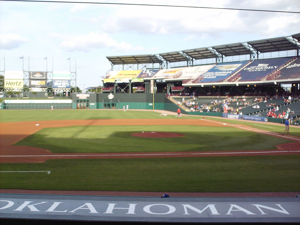
We definitely need to restore Bricktown Ballpark's upper deck seating where the advertising taps are. Would love to see a 15,000 plus crowd at a AAA game. We may never see an 18,000 overflow Oklahoma record crowd that was set at All Sports Stadium.
Participating Member
With the (hopefully) coming RTA, and all the improvements downtown that are getting ready to come online, perhaps it's time to focus on something else for a bit. I'm not suggesting we abandon the idea of using MAPS to promote public transit, or that downtown is "done" and doesn't need any more improvement. I am just saying that downtown will look much different in a few years once the streetcar, the park, and the convention center are complete. I think it's alright to shift our focus temporarily so that we can see the changes take effect. And as far as transit goes, people are probably going to want to try out the streetcar and see if they like it before they vote to expand it. Plus, if the RTA vote fails, future streetcar plans will definitely have to be modified.
Also, local stuff seems to be more popular with voters, and too much focus on downtown and business interests makes MAPS less popular.
I would suggest the following for MAPS 4:
--A citywide beautification project. Planting trees, public art, cleaning up creeks and streams, repairing things that look like crap.
--A citywide bike/walking trail system. This should tie in with future plans for mass transit.
--300 miles of sidewalks. Self explanatory. It needs to be easier to get around the city without a car.
--1 minor and 1 major project for each ward. Spread the projects around a bit so that voters feel like you're doing something just for them.
For instance, in Ward 4 you've got Oliver Park on Santa Fe between 29th and Grand Blvd. It looks like crap. There's nothing to do there. It is just empty land with a "creek" that is really a drainage ditch that runs right through it. There are depressions with standing water. Fix the park. Put in some baseball and soccer fields, some playground equipment. Make it look nice, so people want to use it and they aren't afraid to take their kids there. Also for Ward 4, maybe redo a lot of the facilities out near Draper Lake (I don't know if the city controls that or the state). Make it feel less like a murder place.
Do something like that with each ward while we gear up for a major MAPS 5. Do it as a 5 year program or something, so you've got time to get the RTA ready to go and can combine that with streetcar expansion.
Participating Member
That picture is exactly why they won’t.
They face west in the summer. Hot as f
Participating Member
Some type of rail from Airport to DT area could give the city a huge boost. It's almost a must have if you want the city to attract more tourism.
Instead of construction, why not consider massively endowing the Oklahoma City Community Foundation so that it could fund grants and scholarships well into the future? Imagine if the city took the same investment it puts into all of these construction projects and instead put those funds into a foundation, which would itself grow, but would also continue to massively invest back into the community? The Community Foundation in recent years has done some really great things and could be a huge resource for education.
VIP Member
I do have to say, an emphasis on the south side and northeast sides would be fair. Also, the idea of ensuring sufficient maintenance, upkeep and updating for early MAPS projects, too, for those not self-sufficient.
In all fairness, that pic you see is from one of the few afternoon early games like what you would see at 2 p.m. game in Chicago's Wrigley Field. Use to sit in those right upper deck seats, great view; if there's anyone who can't afford to get sunburnedthen you haven't met me.
VIP Member
while I totally agree with everything mentioned so far, I think STL makes a good point in that we need for MAPS XX to always be transformational in nature, but we have MAPS light (as in the current MAPS for Streets, MAPS for Kids, MAPS for the Thunder, etc) that are just a year or two with a specific focus that isn't capital transformational but IS transformational for OKC!!
So with that in mind, I propose a 3-year ~$375M MAPS for Beautification and Transportation which would include the following projects (many already mentioned):
*** Beautification $125M ***
* Tree Canopy $25M: Establish a Tree Bank to put trees at every major entrance, interchange, and along every major street. Fill-in trees along neighborhood streets where necessary. One thing nobody mentions but would make a HUGE, transformational impact in OKC would be to add trees INSIDE parking lots (not just to the perimeter). We could dedicate a few dollars for this for certain large, ugly but privately owned parking lots where a new city ordinance is passed requiring trees inside lots but the city would use this to go 50/50 with owners: win-win! And again, this is a tree bank where additional dollars can be added (so it's not JUST Maps) but this MAPS would get it started in a HUGE way.
* City Art $25M: Establish a Public Art bank which adds art, sculpture, fountains, monuments at major entrances/interchanges and at various prominent spots in the city. One of the other threads mentioned a need to honor a local civil rights activist many don't know (Roscoe I forget his last name, so sorry....). This would be the kind of thinking, a monument to him in Bricktown to teach all and honor his legacy/impact that helped make OKC great. As this is also a bank, it could receive funding from elsewhere but MAPS would kick start it.
* Bridge beautification $20M. Establish a fund to beautify bridges in this city, particularly along the Oklahoma River. Most of the bridges in this city were built with function in mind. However, this has been to the detriment of the city since they have added to the dusty, ugly scene we have. This would be a step in the right direction to add facades to bridges that honor the city's past or present legacies, perhaps create a non-functional 'suspension' type facade, make a few Oklahoma type bridge facades (maybe the state can pitch in), perhaps redo Sissortail bridge to add in the nonfunctioning but artistic cables that were cut.
* Sidewalks $20M. As was mentioned, every new MAPS should have a sidewalk component until OKC has sidewalks completely filled in every street in the greater city core (basically I-44 to I-35 to near S 44th) and along every major street (both sides) and most neighborhood streets that connect to schools, public venues/amenities, entertainment districts, and are along transit. Individual neighborhoods outside of the city core would be a case-by-case basis. [just wanted to insert that this idea is a master plan for sidewalks, the $20M would just construct what would be coordinated with the other projects listed here in this mini-maps, there'd be other maps to add up/finish the sidewalk master plan. Ditto that for crosswalks and other 'master plans' ive noted].
** Crosswalks $10M+. A subproject to sidewals, but we need better crosswalks in this city at every major interchange where sidewalks (and transit) would connect, every intersection in the downtown core and in the greater core where sidewalks/transit exist, and key mid-block locations in entertainment and historical districts (think Auto Alley!!!!, Film Row, Uptown, Plaza, Asian District, Bricktown, Paseo, 39th, Stockyard's City, Eastside, and Capital Hill) and OCU. Midblock crosswalks will have solar powered activated lighting and perhaps raised. Walkable districts = walkable city!
* Bike Lanes: Not really sure of the cost here, but dedicate key grade separated bike lanes (like Laramie's pics) along at least one major street every direction from downtown within the greater city core. In the downtown core, dedicate a few major streets not served by streetcar to be the bike lane streets.
* Lighting $25M. Lighting added to every street in the greater city core, and along every major street/avenue in the city grid. Partner with the state to ensure ALL freeways in the city (and metro) are well lit. Ensure every single bus stop and route is well lit. Bright Lights = Big City!
*** Transit ***
* Transit Stops $??. Ensure every bus and streetcar stop in the greater city core has a functioning platform and shelter at minimum that is well lit and has tree foliage and perhaps some public art significant for that stop/neighborhood (notice a theme yet?). Every stop in the core is ADA and connected to sidewalks that connect inside the neighborhoods. This IS transformational for OKC!
* Local Transit additions: Not sure the amount, but dedicate funding to capital purchase of buses so that the city can have most routes running M-F 5am-11pm, Sat 8am-11pm, Sun 9am-10pm. Encourage EMBARK to extend OWL routes once per hour Th-Sat 11pm-3am.
* Airport Transit: Capital purchase of a few luggage capable large buses to run Express from downtown to WRWA daily 9am-8pm (maybe earlier M-F and more frequently for run-hour purposes) and a few to go from other 'future transit center' points in the city (like NW Xpressway somewhere and maybe Crossroads) to WRWA but less frequently.
* Commuter Transit: Partner with OCOG and the RTD for commuter bus purchases. Encourage RTD to establish bus routes connecting to the suburbs, including some that will be eventually replaced with Commuter Rail.
* Commuter Rail: Partner with RTD on commuter rail purchase, rail infrastructure upgrades, and stations within OKC city limits at 'N Broadway Ext PnR', '63rd street stop', already funded 'Santa Fe Transit Center', and 'Crossroads PnR'. Encourage the suburbs to build/retrofit their stations in Edmond, Moore, and Norman; long term eventually Guthrie and Purcell.
* Streetcar Extensions $125M:
** Classen $40M: Extend from Midtown to the Asian District along Classen with track on both sides of the street. Enable turns-offs at 23rd Street and possibly going S on Classen from Midtown (and perhaps 16th). This would be roughly 4 miles of track + stations (that can also be used for bus). Maybe partner with OCU if they wanted a turnaround that connected to the campus from the Asian District.
** OHC $35M: Extend down Sheridan to Lincoln up into the OHC with terminus at OU Medical Center campus. Have turn-offs at 4th, 10th, and one that could keep going up Lincoln at somewhere near the OU terminus for future expansion. Partner with OU to share costs. Basically 5 miles of track but OU/state of OK sharing some of the cost.
** Capital Hill ~ $50M: Go down Robinson from the OKC BLVD intersection, double tracked to just past Capital Hill HS. Not sure on the cost of this one since it will involve a few bridges but it is roughly 2.5 miles each way. There could be funds from the Scissortail Park MAPs (and maybe the CC) to build their stations which could reduce this budget.
I'd coordinate the Tree planting and Art at major entrances and freeway interchanges to get the biggest impact while keeping spending low. I'd force these maps components to coordinate budget and schedule wherever there are overlaps in locations (and there will be numerous). The idea is, if we're building a streetcar station then lets also plant the trees, install the sidewalks/crosswalks, lighting, and transit routing at the same time to reduce total cost. ...
Last edited by HOT ROD; 06-16-2018 at 03:53 PM. Reason: revised the sidewalk initiative to a master plan
Oklahoma City, the RENAISSANCE CITY!
I like this of course, but IMO you'd need to spend $100M+ to have a deep, meaningful impact on our lack of sidewalks in this city. And even that probably wouldn't do what you're seeking. MAPS 3 started at something like 18M, got cut to 9M, eventually put back to ~18M*, and you can still drive in plenty of dense places around the core and think, where are the bloody sidewalks. This also doesn't account for the places that technically have sidewalks, but where they may as well not be there (e.g. recent discussions about Walker and places with alternating sidewalks and non-sidewalks due to removal). You could probably literally have a full up "MAPS for Sidewalks" 5 year tax collection only for sidewalks, put a hella bunch of sidewalks in (as well as make repairs), and still have non-trivial gaps in important places. I don't at all mean to be discouraging of the incremental efforts, we definitely need them. I'm just saying that the problem is so monumentally bad (city-wide, I know you focused on the core, but there are places core-adjacent that are sorely lacking as well -- not talking about the near-burbs even) that it could take us a generation to fix it done incrementally. If someone has the figures handy (I'm sure it's out there) regarding total number of sidewalk miles in OKC, and the cost per mile I'm sure we can come up with numbers closer to what's needed vs my obvious hyperbole here (apologies, making a point).
*I doubt these numbers are precise, point is meant to be illustrative
VIP Member
shawn, no doubt it will be higher to implement the ideas I brought up. It's just that the figure I gave was just for my proposal of a maps for beauty and transportation to keep the overall plan within a MAPS like schedule. Dont be afraid/alarmed of my proposal though, as its the master plan idea for sidewalks *and perhaps I should have phrased it as such* not meant to accomplish all of that with just $20M.
We could very well do a monster Maps for Sidewalks and devote for a single year to get $130M+ for just sidewalks. But there are other things that sidewalks need in order to be utilized (lighting, trees, transit) that I think also need to be there and if we coordinated their construction we could save money overall. This is why I'd propose we have every MAPS (be it the big transformational ones of I, II, III, IV or the mini-MAPS of today), every one should have a sidewalk/transit budget since this city is so far gone. But in consideration of the previous MAPS as well as this current mini-Maps and the GoBond that just passed have sidewalks as well; my proposal just adds to that to get us to what needs to be done next.
Oklahoma City, the RENAISSANCE CITY!
There are currently 1 users browsing this thread. (0 members and 1 guests)
 Posting Permissions

 Reply With Quote

Bookmarks