

Right on time coinciding with the beginning of the SW Monsoon that brings in Pacific moisture on the west side of the high pressure ridge. Arizona and other areas get most of their yearly rainfall during this period.Originally Posted by Anonymous.


Right on time coinciding with the beginning of the SW Monsoon that brings in Pacific moisture on the west side of the high pressure ridge. Arizona and other areas get most of their yearly rainfall during this period.
 Participating Member


The breakdown of this heat dome that was mentioned earlier looks like it will come to fruition. Slight rain/storm chances Saturday evening through Monday morning, this will be random pop-up and outflow boundary developed storms. You are lucky to get hit by one.
After a small stint of lower 90s for highs at the beginning of next week, the death ridge comes back even stronger and it appears we could begin a solid streak of 100F+ days over much of the state.
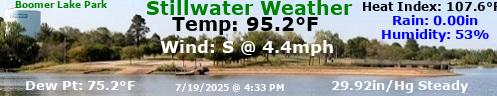
Heat advisory on for much of the central part of the nation. On Thursday, locations in central Oklahoma reached 100 for the first time this summer with dew points in the low 70s. A temporary break in the heat at is forecast to come on Monday and Tuesday with a good chance of rain. If it rains enough then, it will keep the grass green and lawn mowers running where the rain hasn't already been lacking much.
The heat advisory has been upgraded to an excessive heat warning in some counties, but does not include Oklahoma City:
Excessive Heat Warning EXCESSIVE HEAT WARNING Excessive Heat Warning
Areas Affected:
Atoka - Coal - Hughes - Lincoln - Payne - Pontotoc - Pottawatomie - Seminole
Effective: Sun, 7/23 12:00pm Updated: Sat, 7/22 3:26pm Urgency: Expected
Expires: Sun, 7/23 8:00pm Severity: Moderate Certainty: Likely
Details:
...HEAT ADVISORY REMAINS IN EFFECT UNTIL 8 PM CDT THIS EVENING...
...EXCESSIVE HEAT WARNING IN EFFECT FROM NOON TO 8 PM CDT
SUNDAY...
The National Weather Service in Norman has issued an Excessive
Heat Warning, which is in effect from noon to 8 PM CDT Sunday.
The Heat Advisory is no longer in effect.
* TEMPERATURE...Heat indices will range from 103 to 109 degrees
through early this evening. The hot temperatures and the humid
air will create heat index values 108 to 113 Sunday afternoon.
* IMPACTS...Heat exhaustion and heat stroke are possible for
persons working or playing outside.
Information:
Take extra precautions, if you work or spend time outside. When
possible, reschedule strenuous activities to early morning or
evening. Know the signs and symptoms of heat exhaustion and heat
stroke. Wear light weight and loose fitting clothing when
possible and drink plenty of water.
To reduce risk during outdoor work, the occupational safety and
health administration recommends scheduling frequent rest breaks
in shaded or air conditioned environments. Anyone overcome by heat
should be moved to a cool and shaded location. Heat stroke is an
emergency, call 9 1 1.
Counties affected by excessive heat warning in purple:
Participating Member
Much needed rain fell south of I-40 over the weekend, but was still very localized.
Pattern change coming for the end of the week with storm chances Thursday night. We will then be in more of a Northwest flow, which will keep the heat dome pushed to the south and west into western TX. This will help cap high temperatures in the upper 80s to lower 90s. Which is well below average for this time of the year. Unfortunately, significant rain chances don't look likely until maybe middle of next week with potential tropical play.
Participating Member
Is that just for Thursday or for several days after? My schedule for this weekend has me outdoors way more than I'll be indoors. So that temp range would be pretty awesome for the weekend!
Participating Member
The lower temperatures would be for Friday and through the weekend. If everything holds true, it will be a nice break from the 100s.
I drove to Oklahoma City on Sunday and later that afternoon drove back home through a few light showers. Since no lightning and thunder associated with them, I wasn't surprised there was only .02" recorded in my rain gauge when I got home.
Elsewhere, some of the storms turned quite windy and some drivers had close calls with a row of utility poles blowing down. One lady said as she was driving a line fell on her back window, knocking it out, making her stop and then a pole fell in front of the car.
The cold front wasn't very strong temp wise, but at least it was strong enough to knock out the heat advisory.
http://www.news9.com/story/35952629/...d-in-lexington
HEAT ADVISORY BACK FOR TUESDAY:
Updated: Mon Jul-24-17 03:31pm CDT
Effective: Tue Jul-25-17 12:00pm CDT
Expires: Tue Jul-25-17 08:00pm CDT
Severity: Minor
Urgency: Expected
Certainty: Likely
Status: Actual
Type: Alert
Category: Met
Areas affected: Atoka; Bryan; Canadian; Carter; Cleveland; Coal; Garfield; Garvin; Grady; Grant; Hughes; Jefferson; Johnston; Kay; Kingfisher; Lincoln; Logan; Love; Marshall; McClain; Murray; Noble; Oklahoma; Payne; Pontotoc; Pottawatomie; Seminole; Stephens
Instructions: A heat advisory means that a period of hot temperatures is expected. The combination of hot temperatures and high humidity will combine to create a situation in which heat illnesses are possible. Drink plenty of fluids, stay in an air-conditioned room, stay out of the sun, and check up on relatives and neighbors. Take extra precautions, if you work or spend time outside. When possible, reschedule strenuous activities to early morning or evening. Know the signs and symptoms of heat exhaustion and heat stroke. Wear light weight and loose fitting clothing when possible and drink plenty of water. To reduce risk during outdoor work, the occupational safety and health administration recommends scheduling frequent rest breaks in shaded or air conditioned environments. Anyone overcome by heat should be moved to a cool and shaded location. Heat stroke is an emergency, call 9 1 1.
Message summary: ...heat advisory in effect from noon to 8 pm cdt tuesday...
The national weather service in norman has issued a heat advisory, which is in effect from noon to 8 pm cdt tuesday.
* temperature...high temperatures will range from 95 to 100 degrees with heat indices from 102 to 107 degrees tuesday afternoon.
* impacts...heat exhaustion and heat stroke are possible for persons working or playing outside.
Affected counties in orange:

Gold Member
We need some rain or a front to get out of the hot spell. I am mowing at 7am to avoid a heat stroke.
I've been pushing it out to about 7:30pm and it's actually fairly pleasant by then. I can't wait too much longer; last night I got pushed out to about 7:45 and barely had enough light to see the dog as I walked back into the house

Participating Member
One of my neighbors consistently mows after dark... even if it's 80 during the day. Ha.
Participating Member
I hope these models validate!

Participating Member
Short-range models showing storm development as we head toward early evening. Placement will be random, but the best chances are along and just north of I-40. This will be very localized heavy rain and brief microbursts of wind out of collapsing storms. As usual in the summer here, consider yourself lucky to be under one.
Our below average temperatures begin tomorrow and continue as we head toward August. Some more slight rain chances moving in late weekend.
Some model suggestions of concentrated heavier rain across NW areas of OK.
Participating Member
Some cumulus towers trying to rise across C OK currently. May see a quick storm or two develop over the next couple hours here around OKC with this sunlight quick-heating the environment.
Participating Member
It's more like late September today than July! I'm loving it.
Banned
I bet tomorrow will feel more like August.
Participating Member
nm
Participating Member
Haha, hopefully a "cool" August! Though I'm ready for some rain.
Gold Member
Wow I read this and thought well I mean August is usually hot so I guess it will be hotter tomorrow. I'm an idiot.
Banned
Amen!
There are currently 1 users browsing this thread. (0 members and 1 guests)
 Posting Permissions

 Reply With Quote


Bookmarks