

Anybody worried about Friday should watch Aaron Tuttle's most recent livestream.
A lot could go wrong with this setup. The TV meteorologists are jumping on the worst possible scenario, which at this point is definitely not a sure bet.

 Participating Member


Anybody worried about Friday should watch Aaron Tuttle's most recent livestream.
A lot could go wrong with this setup. The TV meteorologists are jumping on the worst possible scenario, which at this point is definitely not a sure bet.
Participating Member
Yeah the amateur mets I follow are extremely skeptical on Friday being absolutely cataclysmic but they do say if literally everything lines up perfectly and it's a lot of stuff that has to line up perfectly it does have the potential to put out some very dangerous storms, one met said it'd probably be the strongest we've seen yet this year. But again literally everything would have to fall into line perfectly and that's a very very very slim shot right now.
Participating Member
This is why I can no longer follow/watch Morgan. How can he make this prediction when everyone else is a notch or two below ?
 Participating Member
Well I can guarantee there will be some Thunder in OKC Friday night.... And my original plans were to walk the mile from from my office to the game..... The TV mets last night were saying it could be over in OKC by evening time.... So I sure am hoping they are right.
Participating Member
More assured hazards from the system the next few days look to be the potential for flooding rains. NWS Forecast Discussion talks about the potential for 1.5-5.0" of rain in central and north-central Oklahoma, particularly late Thursday into Friday just north of wherever the warm front sets up.
Participating Member
Nor I. I also know some folks in the Emergency / Hazard mitigation biz who refuse to work with him. He looks at all possible scenarios and goes with the one that's most hypable.Originally Posted by Prunesmoothie

Banned
Mike MORGASM = fear monger. Odds are he will be right a certain % of the time. But as you said, almost always goes with the most HYPABLE.
I also know (well, knew) some folks in that emergency/hazard business who told me that a *bunch* of changes and "Don't EVER do this again"-type information was trickled down about that fiasco without ever mentioning his name. I think what he did became a bit of a sad joke in the industry, although it obviously wasn't funny.
Participating Member
I don't know about storms, but looks like the rain is pretty much expected to be heavy.
... FLOOD WATCH IN EFFECT FROM LATE THURSDAY NIGHT THROUGH FRIDAY EVENING... THE NATIONAL WEATHER SERVICE IN NORMAN HAS ISSUED A * FLOOD WATCH FOR FLASH FLOODING... FLOODING OF CREEKS AND RIVERS... AND FLOODING OF LOW LYING AREAS FOR PORTIONS OF CENTRAL OKLAHOMA, EAST CENTRAL OKLAHOMA, AND NORTHERN OKLAHOMA, INCLUDING THE FOLLOWING AREAS, IN CENTRAL OKLAHOMA, CANADIAN, CLEVELAND, GRADY, KINGFISHER, LINCOLN, LOGAN, MCCLAIN, OKLAHOMA, PAYNE, AND POTTAWATOMIE. IN EAST CENTRAL OKLAHOMA, SEMINOLE. IN NORTHERN OKLAHOMA, GARFIELD, GRANT, KAY, AND NOBLE. * FROM LATE THURSDAY NIGHT THROUGH FRIDAY EVENING * RAINFALL TOTALS OF 2 TO 4 INCHES WITHIN AND CLOSE TO THE WATCH AREA. HIGHER AMOUNTS ARE POSSIBLE. PRECAUTIONARY/PREPAREDNESS ACTIONS... A FLOOD WATCH MEANS THERE IS A POTENTIAL FOR FLOODING BASED ON CURRENT FORECASTS. YOU SHOULD MONITOR LATER FORECASTS AND BE ALERT FOR POSSIBLE FLOOD WARNINGS. THOSE LIVING IN AREAS PRONE TO FLOODING SHOULD BE PREPARED TO TAKE ACTION SHOULD FLOODING DEVELOP. &&
There is a flood watch for more than the northeastern quarter of the state. It includes Oklahoma City.
FLOOD WATCH
Areas Affected:
Canadian - Cleveland - Garfield - Grady - Grant - Kay - Kingfisher - Lincoln - Logan - McClain - Noble - Oklahoma - Payne - Pottawatomie - Seminole
Effective: Wed, 4/19 3:45pm Updated: Wed, 4/19 5:51pm Urgency: Future
Expires: Sat, 4/22 12:00am Severity: Moderate Certainty: Possible
Details:
...FLOOD WATCH IN EFFECT FROM LATE THURSDAY NIGHT THROUGH FRIDAY
EVENING...
The National Weather Service in Norman has issued a
* Flood Watch for flash flooding...flooding of creeks and
rivers...and flooding of low lying areas for portions of
central Oklahoma, east central Oklahoma, and northern
Oklahoma, including the following areas, in central Oklahoma,
Canadian, Cleveland, Grady, Kingfisher, Lincoln, Logan,
McClain, Oklahoma, Payne, and Pottawatomie. In east central
Oklahoma, Seminole. In northern Oklahoma, Garfield, Grant,
Kay, and Noble.
* From late Thursday night through Friday evening
* Rainfall totals of 2 to 4 inches within and close to the watch
area. Higher amounts are possible.
Precautionary/preparedness actions...
A Flood Watch means there is a potential for flooding based on
current forecasts. You should monitor later forecasts and be alert for possible
Flood Warnings. Those living in areas prone to flooding should be
prepared to take action should flooding develop.
AREA COVERED:

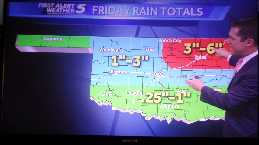
Channel 5 forecasts as much as 3 to 6" of rain in the northeast part of the state:
 Participating Member
Is anyone else getting the following screen when trying to pull up the Storm Prediction Centers website??

Participating Member
First wave of storms develops this evening just west of I-44 corridor, then trains over the state. Temperatures are going to be knocked down into the upper 60s with this cold front coming through right now, so lacking instability will limit severe potential. There is still a chance some of the storms could try and drop small hail, especially early on in lifespan. Flash flooding will be primary threat with storms likely crossing the same regions.
After this initial wave of storms, models suggesting another forming out in the TX PH and pushing east during the early morning hours for Friday.
Then perhaps one more attempt at a round later Friday, but this is looking more likely that it would be contained to S and E OK. Will monitor changes.
Participating Member
They've been having problems off and on with it for the past few days. I know they're aware of the issue but I'm not sure what is being done to address it.
Participating Member
Ok, Thanks just glad to know it isn't just me having the issue.
Participating Member
Looks like we are in an Enhanced Risk for Friday now.
![Click image for larger version.
Name: image4[1].jpg
Views: 117
Size: 28.9 KB
ID: 13772](https://www.okctalk.com/attachment.php?s=5550f7a842f2ce8ac8453b160a4c6a01&attachmentid=13772&d=1492710884&thumb=1)
Participating Member
According to Damon Lane, it looks to be primarily a hail threat and not as much a tornado threat.
Participating Member
Snapshot of the type of waves we will be seeing overnight and into Friday morning. Heaviest rain projections are along and just south of I-40 where heavier thunderstorms are favored.

Participating Member
MD out for C and S OK.
Mesoscale Discussion 0529
NWS Storm Prediction Center Norman OK
0540 PM CDT Thu Apr 20 2017
Areas affected...Northwest TX...OK
Concerning...Severe potential...Watch possible
Valid 202240Z - 210015Z
Probability of Watch Issuance...60 percent
SUMMARY...Thunderstorms are expected to develop across northwest TX
into central OK this evening. Large hail is the primary risk with
this activity.
DISCUSSION...Surface front has stalled from east central OK into
northwest TX early this evening. With surface temperatures in the
mid 80s across northwest TX a corridor of modest instability has
developed from the TX South Plains to near the Red River. Latest
visible satellite imagery depicts a thickening CU field along the
front with deeper convection over Haskell/Knox Counties in TX
producing weak echo returns. As LLJ strengthens across this region
into southwest OK this evening it appears a marked increase in
thunderstorm activity will be observed. Numerous elevated
thunderstorms should blossom north of the boundary and adequate
mid-level lapse rates are in place for robust updrafts. Greatest
risk with this activity should be hail.
..Darrow/Dial.. 04/20/2017
Participating Member
Good soaking in Northern OKC so far.
Participating Member
The final heavy stuff is swinging through toward C OK right now. Most of OKC will likely top 2.5".
Severe threat for this afternoon will be SE OK.
Participating Member
This final wave coming in is now severe. Strong gusty winds and flash flooding.
Participating Member
Deer Creek schools cancelled today, due to weather related power outages. You don't see that every day. We live in the DC district and at 2:00 am I was hoping and praying the power would not go off.
Owner / Administrator

Holy hail storm!
Fortunately, it was all pea sized, at least at my house.
Participating Member
Looks like we get a break for awhile then we are looking at another weather feature Thursday/Friday. The NWS was highlighting Friday this morning. Again, pretty meaningless 7 days out, but there will be something in the area right when we get to the peak of severe weather season. The risk is there until the high pressure builds in the summer.
There are currently 1 users browsing this thread. (0 members and 1 guests)
 Posting Permissions

 Reply With Quote


Bookmarks