Widgets Magazine
Results 1 to 16 of 16

Thread: Maps and History of Oklahoma County 1830-1900

  1. Default Maps and History of Oklahoma County 1830-1900

    http://dougdawg.blogspot.com/2010/10...ma-county.html

    This new article shows graphically and text how Oklahoma County came to be. Everyone knows about the 4/22/1889 Land Run ... not as many know that much about the Native American History which preceded it beginning in 1830 or the 3 smaller land runs that occurred into what would finish out what would become eastern Oklahoma County in 1881 and 1883, that being the east-most six miles east of the Indian Meridian.

    In researching for this article, I've run across several new vintage maps that I'd not earlier located and they are all in the article, some very high resolution. These maps came from the Library of Congress, the University of Alabama Maps pages, and the Oklahoma State Library on NE 18th Street.

    The maps made by the George F. Cram Co., Chicago, are some of the best maps I've seen of the very early days.

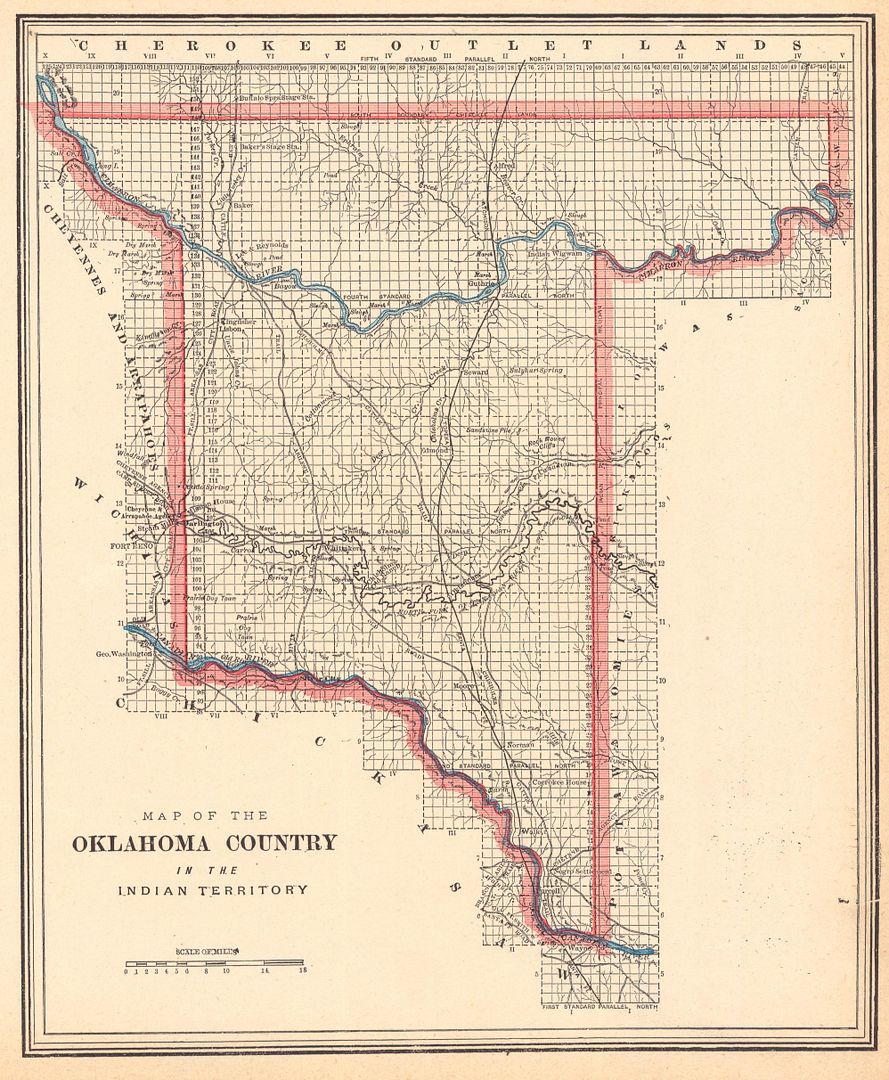
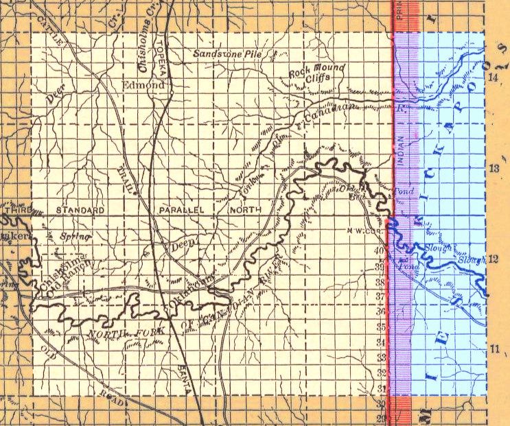
    The 1st impressive map by his company was the very detailed 1887 map of the Unassigned Lands which was located at the University of Alabama website -- each horizontal and vertical line is a section line, 1 mile apart from each other. The map also contains trails and other interesting information.


    From same map, a crop of the Oklahoma County portion


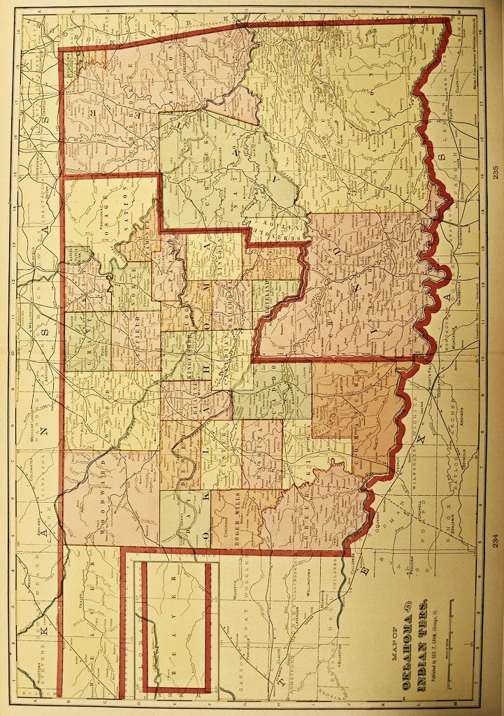
    One of the more interesting Cram maps shows Oklahoma County in 1895 in greater detail than I've seen anywhere else. I'll reach that point in the article tomorrow or Sunday, but here's a preview now, not yet in the article:

    The map below was a Cram 1895 map located at the the Oklahoma State Library on NE 18th Street ... they don't make or have copies of their original maps but one can take photos with one's camera, and here's the best that I could do of the state ...

    Click here for larger view


    As far as Oklahoma County was concerned, this map shows more detail of one-time county towns than any other map I've seen during this general time period ...


    The back side of this map shows locations and populations of the various towns in the map where availabld. Oklahoma Territory and Indian Territory

    There's more to be done ... I'm up to the 4/22/89 Land Run, to be followed by the smaller land runs in 1891 and 1893, and to be concluded with a look at the towns located in Oklahoma County shown by pre-1900 maps, the Cram map above being the best I've found so far.

    The article should appeal to map lovers and to people curious about how Indian Territory, the Unassigned Lands, and Oklahoma County developed step by step.

  2. #2

    Default Re: Maps and History of Oklahoma County 1830-1900

    I like it!! It's funny that the area had two towns/locations named Mishak. My dad told me that there was a town that attempted to take the name Dewey. When told the name had already been used, they called their town Yewed.

  3. #3

    Default Re: Maps and History of Oklahoma County 1830-1900

    Retrop, near Altus, took on it's name when they found that Porter was already in use.

  4. #4

    Default Re: Maps and History of Oklahoma County 1830-1900

    cool stuff... never knew the chisholms had a ranch in the area... best i can tell it was north and east of the bend in the canadian river, near modern-day lake overholser... wondering the exact location. -M

  5. #5

    Default Re: Maps and History of Oklahoma County 1830-1900

    You are amazing repository of information. Thanks, so much!

  6. Default Re: Maps and History of Oklahoma County 1830-1900

    Quote Originally Posted by mmm View Post
    cool stuff... never knew the chisholms had a ranch in the area... best i can tell it was north and east of the bend in the canadian river, near modern-day lake overholser... wondering the exact location. -M
    Thanks, guys.

    Martin, the only thing I know with certainty about Chisholm having a "place" in Oklahoma County was his trading post located in/at Council Grove township which later became a US timber reservation -- see http://dougdawg.blogspot.com/2008/06/council-grove.html -- and that appears to be the same location shown for the "ranch" in Cram's map. If he had a ranch there, also, I don't recall reading about it in any literature but I plan to check it out. Cram's maps do seem more accurate to me than many others, certainly better than Rand McNally's during the 19th century.

    Plus, "Chisholm's Ranch" is also shown in this 1873 map prepared by the US General Land Office (also included in the article) -- I've not scrutinized this location to see if matches Cram's map (or where we know Council Grove to be).

    Click here for large map


  7. #7

    Default Re: Maps and History of Oklahoma County 1830-1900

    There's Dewey and Yewed, Porter and Retrop, but what about Ada?

  8. #8

    Default Re: Maps and History of Oklahoma County 1830-1900

    Quote Originally Posted by doug loudenback
    Martin, the only thing I know with certainty about Chisholm having a "place" in Oklahoma County was his trading post located in/at Council Grove township which later became a US timber reservation
    now that you mention it, the boundaries of the "old chisholms ranch" from the 1887 cram map match up pretty much exactly with what i've seen as the borders of the council grove timber reservation... -M

  9. Default Re: Maps and History of Oklahoma County 1830-1900

    Quote Originally Posted by Tritone View Post
    There's Dewey and Yewed, Porter and Retrop, but what about Ada?
    Huh?

  10. #10

    Default Re: Maps and History of Oklahoma County 1830-1900

    Ada spelled backwards is still Ada. Pretty lame attempt at humor. I'll do better next time (can't do much worse).

  11. #11

    Default Re: Maps and History of Oklahoma County 1830-1900

    as is Harrah!

  12. Default Re: Maps and History of Oklahoma County 1830-1900

    The more I delved into stuff, the longer the originally contemplated article, Oklahoma County 1830-1900, became. I came to decide that the article needed to be broken into 2 pieces, Part 1 (1830 ~ noonish on 4/22/1889) and Part 2 (noonish 4/22/1889 - 1900).

    Part 1 is now done, it taking more than a month to complete. It is also available in a single 40 page PDF file, for any that might want to read that much or print it.

    I've embarked on Part 2 but only as a holding place. I've done most of the research for it, but it takes time to put together and I need to put it down until after I've done other more pressing stuff: 1) The 2010 Paseo Arts Council Awards (which has already happened) and 2) Christmas 2010 in which were are in the midst and coming up so very quickly.

    The general (subject to change) outline of Part 2 is:

    Topics to be discussed in Part 2 include the following:

    1. Freaky Monday — Land Run Day
    2. Townsite Chaos When No Effective Law for Townsites Existed
    3. Initial Townsite Controversies In Oklahoma Country, in Kingfisher, Guthrie and Oklahoma City
    4. Oklahoma City Particularly — the Seminole Townsite Company, and Its Adversaries
    5. Oklahoma Becomes A Territory — the 1890 Organic Act
    6. 1890 Townsite Legislation
    7. Resolution of Legal Sooner Questions
    8. Oklahoma Territory Is Formed
    9. The 1st Territorial Governor
    10. The 1st Territorial Legislature (we was robbed) but also forming Oklahoma County
    11. Railroad Developments
    12. How Oklahoma City Paid Huge Bucks For Its Conspiracy to Acquire Its City Hall Property — $157,456 (in 2009 dollars) — From Illegal Sooners
    13. Summary At the Turn of the Century

    The list may be different when all is done, but that's my general game plan.

  13. #13

    Default Re: Maps and History of Oklahoma County 1830-1900

    Quote Originally Posted by Tritone View Post
    Ada spelled backwards is still Ada. Pretty lame attempt at humor. I'll do better next time (can't do much worse).
    I got it - if it makes you feel better, it brought a smile!

  14. #14

    Default Re: Maps and History of Oklahoma County 1830-1900

    Thanks. Careful, you'll just encourage me.

  15. #15

    Default Re: Maps and History of Oklahoma County 1830-1900

    Doug, these are so interesting!


Thread Information

Users Browsing this Thread

There are currently 1 users browsing this thread. (0 members and 1 guests)

Similar Threads

  1. Oklahoma County Assessor Leonard Sullivan won't discuss his role in will
    By urbanity in forum Current Events & Open Topic
    Replies: 17
    Last Post: 01-26-2011, 09:53 AM
  2. Replies: 0
    Last Post: 06-16-2007, 12:17 PM
  3. Oklahoma County - A Step Back in Time - WoW!
    By OkieKAS in forum General Civic Issues
    Replies: 10
    Last Post: 05-02-2007, 10:37 AM
  4. Oklahoma History Center
    By Doug Loudenback in forum General Civic Issues
    Replies: 4
    Last Post: 11-03-2006, 12:22 PM
  5. Odd happenings at the Oklahoma County Courthouse
    By okcnative in forum General Civic Issues
    Replies: 29
    Last Post: 10-06-2006, 08:16 PM

Bookmarks

Posting Permissions

  • You may not post new threads
  • You may not post replies
  • You may not post attachments
  • You may not edit your posts
  •  
Single Sign On provided by vBSSO