

Interesting.
They presented 3 options, none of which were that great. Letstalktransit.com should have the meeting information up soon.

 Andrew Stewart

Interesting.
They presented 3 options, none of which were that great. Letstalktransit.com should have the meeting information up soon.
Participating Member

Searching for direction - MAPS 3 streetcar
Officials ponder details of MAPS 3 streetcar system
By Brian Brus
The Journal Record
OKLAHOMA CITY Supporters of a streetcar system and city planners originally imagined certain destinations would likely be chosen as anchors in a downtown Oklahoma City fixed-rail transit route.
We had no preconceived ideas about where it should go, although we had guessed what people would want, said Rick Cain, director of public transportation and parking for the Oklahoma City municipal government.
But as weve moved on, their ideas have shaped several main route options that were looking more closely at. Sometimes its a little surprising to see the process in action.
And as Keith Jones told several hundred attendees at the annual Mayors Development Roundtable on Wednesday, That track is pretty permanent, so you want to be very smart about where you put that track down the first time. What I try to tell folks is that its more art than science.
Jones, vice president and regional transit manager of URS Corp., was a keynote speaker at Mayor Mick Cornetts event this year, addressing the challenges of establishing a streetcar system maintaining funding, future expansion potential and routing decisions. Jones was joined in the discussion by Cain; James Ellison, marketing and development specialist for Othello Partners Inc. and vice chairman of the local Modern Transit Project; and Tom McDaniel, Oklahoma City University president and chairman of the MAPS 3 citizens advisory committee.
In December, Oklahoma City voters approved the MAPS 3 sales tax, which will be collected for almost eight years before expiring. The initiative will raise about $777 million to fund eight projects, including $130 million for a transit package of five to six miles of a downtown streetcar.
The streetcar will be on rails in city streets and link major employers, businesses, attractions and residential communities in the downtown area. The MAPS 3 ballot text did not provide specific details about the project, leaving it open for public input. To that end, the Central Oklahoma Transportation and Parking Authority offered an online survey and held public meetings at City Hall.
Cornett said Wednesday the scheduling of MAPS 3 projects hasnt been set yet, which adds another glitch in determining the final route.
As Cain put it, If we were to build it tomorrow, you might see one route.
But if the streetcar doesnt come out for five or seven years, who knows whats going to evolve over that period?
But he said the city is trying to determine streetcar routes as quickly as possible so that work will coincide with another massive, unrelated project: Project 180, a streetscaping project that will extensively change 180 acres of streets, sidewalks, lamps, benches and signage throughout downtown for the next three years. If money can be saved because of overlapping efforts, it would provide streetcar planners more options, he said.
Cain said people dont want to walk more than a block in order to reach a streetcar.
We know we dont have enough money right now to reach every point people would like to go to. So the question becomes how do we position ourselves so that when we do get some additional funding in the future, its an easy connection to grow into, he said.
Feedback so far has resolved into three primary options. In two of the route plans (Option 2 and Option 3), St. Anthony Hospital is an anchor with streetcar rails south to Sheridan and Reno, then east to Stiles and north to the edge of the Oklahoma Health Center campus at Centennial Expressway. Those routes pass the Ford Center, Bricktown Ballpark and the Myriad Botanical Gardens.
A third option (Option 1) also passes those landmarks, but incorporates a second loop that passes east of the Centennial Expressway and around the health center campus. Cain stressed the options are still works in progress and not conclusive.
Jones said city leaders must weigh several considerations in determining where the streetcar will pass and make stops, including: what the resident public wants now for their immediate daily use, what visitors will need for special event destinations, sites that are planned for future development, and existing areas that need a traffic boost.
Getting that balance of serving existing (passenger) generators, but also serving those places where you want to focus on new development and redevelopment is going to be a real challenge, Jones said.
The OCU law school could end up being one of those generators someday soon. McDaniel said the university wants to move the school downtown to take advantage of related legal resources in the area. In response to Cornetts question about the schools needs, McDaniel said mass transit would help solve parking problems.
The trick is having parking places when we need them, McDaniel said. We need a lot of parking places for a very short period of time. So being downtown, we can get our students internships, get them to lawyers offices, get them to courthouses, places where theyll be able to work while theyre students.
Cain said the streetcars interaction with the citys bus system will be a vital component to the health and growth of both components, but it will take time to fully develop that synergy and, ultimately, an intermodal transit hub somewhere in the heart of the city.
Jones said the streetcar will be a game changer because it also will allow greater mobility for Amtrak train travelers.
Searching for direction - MAPS 3 streetcar
Andrew Stewart
None of the 3 options presented addressed the OCU law school.
I just received this release in my email:
Alternatives Analysis Study Begins
COTPA Studies the Future of Transit in Greater Downtown Area
OKLAHOMA CITY - The Central Oklahoma Transportation and Parking Authority (COTPA) is conducting an Alternatives Analysis (AA) study to help guide the long-term development and expansion of transit in the greater downtown area. The study builds upon recent planning for the streetcar project that is part of MAPS 3 passed by Oklahoma City voters in December 2009. The study will take about a year to complete.
The AA is designed to explore additional transit options and determine one that best meets the future needs of the downtown community. This is one of several steps that must be completed in order for the City to be eligible for future federal funding, according to Rick Cain, administrator of COTPA.
The MAPS 3 modern streetcar will provide improved mobility and support economic development in the downtown area and provide the foundation for future growth. The AA is broad in scope and will assess other options that could further enhance public transportation in downtown, explains Cain. If we hope to receive federal funding to grow our transit system, its critical that we have a plan beyond the initial 5 track miles of downtown streetcar and a multimodal transit hub.
A steering committee made up of citizens has been formed to guide the process and to represent the diverse interests of the downtown community. Before making a recommendation to the COTPA Board of Trustees or the City Council, the committee is tasked with appraising the studys findings while considering the input received through this springs Lets Talk Transit public meetings.
An orientation meeting for the AA Steering Committee will occur Wednesday, May 19 from 3 to 5 p.m. at the Civic Center Hall of Mirrors.
The AA Steering Committee includes:
- Jeff M. Bezdek, Modern Transit Project
- Kay Bickham, COTPA Trustee
- JoeVan Bullard, Executive Director, Oklahoma City Urban Renewal Authority
- Mike Carrier, President, OKC Conventions and Visitors Bureau
- Russell Claus, Director, City of Oklahoma City Planning Department
- Mayor Mick Cornett, City of Oklahoma City
- Joseph J. Ferretti, Ph.D., Senior Vice President and Provost University of Oklahoma Health Sciences Center
- Joe Hodges, President, St. Anthony Hospital
- Jane Jenkins, President and CEO, Downtown Oklahoma City Inc.
- Don Karchmer, Bricktown Parking Investors
- Klaholt Kimker, Vice President Administration, Devon Energy
- Steve Mason, President, Cardinal Engineering
- Michael Ogan, Business Development Director, Greater Oklahoma City Chamber
- David Remy, Urban Neighbors Board
- Nancy Love Robertson, Sr. Vice President Communications, Sonic Corporate Headquarters
- Jim Roth, Phillips Murrah P.C.
- Councilwoman Meg Salyer, City of Oklahoma City
- Barney Semtner, COTPA Trustee
- Terry Taylor, Planning and Operations Director, Oklahoma Health Center Foundation
- Jim Thompson, Assistant City Manager, City of Oklahoma City
- Lauren White, President/CEO, NewView Oklahoma
- John D. Williams, General Manager, Skirvin Hilton
- Marsha N. Wooden, Vice President of Administration, SandRidge Energy
Participating Member
In Portland, the streetcar 'loop' makes sense. The streetcar goes one way on a one-way street.
Project 180 converts all of our one-ways back to two-way streets. Wouldn't it be odd to have our streetcars go only one way on two-way streets like the 3 options rececently presented propose?
In this example, the blue line is exactly 2.5 miles (or 5 miles of track). It's super simple and goes through all the downtown districts. PLUS... is easy to expand on and create 'spokes' on a wheel. The three options we've seen seem to jog way too much and would be awkward to expand upon.

Participating Member
I'm not really sure I understand this. If we have a loop, then if the streetcar isn't going the direction you want to go, you either ride the loop until you get where you want to go, or you walk. To have streetcars going two directions would either take two tracks, which is twice as expensive, or you'd have to have a spoke and hub system. Using a spoke and hub system, at any given time the streetcar would be going in the wrong direction for half the people, and they'd have to get on, ride to the end and then ride back the other direction.Originally Posted by Platemaker

Participating Member
I don't know what streetcar system you've been on the requires riding to the end of the line before heading the other direction. You just catch the streetcar on the other side of the street.
Participating Member
I thought we're talking about a single track system. Double track costs a lot more money and takes up a lot more space. Perhaps I am in error.
Participating Member
I didn't think it mattered.... a long skinny 5-6 mile loop... or 2.5-3 mile loop with tracks in both directions.
Participating Member
Depends on how much area they want to cover. A single-track loop is definitely less user friendly, but you can cover more ground for the price.
Participating Member
I think you're really covering basically the same amount of ground... putting the track going the other way a block or two away (which could actually add to your walk depending upon which driection you're taveling)
Participating Member
But, if it were a block or two away, you'd still have a line only going one way on a two-way street. Which gets us back to the original statement. It doesn't bother me at all to have a streetcar going one way on a two way street. The benefit of a loop is that you don't have to think or remember which street the line going the other direction is on. To get to where you want to go, you just get on the streetcar. If it's going the wrong direction, you decide whether it's worth it to walk versus how long it will take you to get there if you have to go around the loop.
In the best of all possible worlds, you have a two track system on the same street, so you don't have to think about anything except which direction you want to go. I'm just not sure what kind of money we have for this system. And, for a starter system, I almost think it's better to cover more ground than to pay for two tracks. I'm just throwing ideas out there, however. I'm sure I'll ride it regardless of how its designed.
Participating Member
How is this....
....covering more ground (really)
than this....
Participating Member
Can we leave out Union Station? I'll be interested to see the ultimate route, but I think you've almost got to run the line there, or you've left Core to Shore completely without access.
Participating Member
I can appreciate the simple approach (sometimes the simplest way is the best way) but it approaches the Loop system that the Mayor was trying to avoid. Unless this loop is the hub of the spoke and hub, but then again, the spokes would be coming much later.
Not familiar with all of downtown but saw a couple of glaring omissions from the blue route (connecting with)...
1) The Ford
2) The City's preferred location of the new Convention Center
3) The MAPS 3 Park
Need to extend it down to the Union Station around the Park/Convention Center. But then how much does that go beyond the 5 to 6 miles?
While they want it to serve a good mix of everyone (downtown businesses, residents & tourists), doesn't seem like a good idea to exclude the tourists either. The main goal of the Streetcars is to serve as a starter for a much larger plan, to get people used to the idea of using mass trans. The harder you make it for some one to use it (number of blocks they are willing to walk to a pickup point), the less likely they are to utilize it and that goes against the stated goal.
This all gets rather complicated and really would have been helpful if routes etc had been determined BEFORE it was decided to include it in MAPS 3 and the info to make an informed decision was put in front of the public BEFORE the vote. IMO
We don't need to go to Union Station -- yet. Remember, this will be a phased system. We need to accomplish the most possible with the initial installation. It doesn't make sense to forego denser, more populated districts for the "hope" that the Union Station area will eventually fill in.
Participating Member
I disagree. Expanding this line will be a slow process. Union Station will be an integral part of Core to Shore, and the park is part of the first phase of Core to Shore. We've already learned that development follows street car lines. One of the best ways to stimulate development in that area is with the street car line. One of the best ways to ensure that our Central Park doesn't become a Will Rogers Park.....out of the way, difficult to access and thus underutilized....is to make it easily accessible immediately. None of the area the line will serve really qualifies as significantly "denser" or "more populated" right now anyway.
Sorry. Given the choice of having a functional, successful transit system, and propping up an underutilized area, I will err on the side of ensuring the street car is a success. Bad route design will doom the streetcar to failure, not a risk worth taking.
Participating Member
If it's just one stop of many, it won't matter. If we were talking about the entire route, I might agree with you. But, a stop at Union Station would undoubtedly be preceded by a stop at Midtown or the CBD and followed, perhaps, by a stop at the Ford Center. If the stops preceding and following it are already highly utilized, it will support the new Core to Shore area without having a negative effect. We'll have to agree to disagree.....not that our opinions carry weight regardless.
The route needs to connect the area's biggest employers to the current and existing living and entertainment areas (St. Anthony's, OU Health Sciences Center, Devon, Bricktown) and worry about the convention center and C2S Park later.
Participating Member
I agree with betts, you HAVE to include the Convention Center and MAPS 3 Park (the park is supposedly one of the first projects to be completed and will include the Convention Center if it goes where they City is wanting it too later on). Union Station is a natural connection and hopefully can be tied into the Streetcars. They are trying to strike a balance with current residents/businesses AND development factors. You can not exclude the development factors and the tourist element. One of the biggest mistakes that you can make is to somehow exclude the tourism $$$, that is primarily NEW money coming into the economy. That can only ultimately increase tax revenues. Isn't this the "rising tide lefts all boats"? This is an absolute MUST.
I know funds are limited and that they are wanting a starter system (thats why I was really surprised/disappointed when MAPS 3 was announced that it only included the Downtown Streetcar element). I fully expected MAPS 3 to be the Big 3 elements the Mayor spoke of nearly every time. Roughly a 10 year penny sales tax for the following:
1) $394M for the all-inclusive Mass Transit plan: "Transit (light rail, streetcars, etc.)" "The resulting plan included better bus service, commuter rail, a modern streetcar for the downtown area and bus rapid transit, which is a hybrid between bus and rail."
2) $400M for the COMPLETE Convention Center (NOT the $280M "Phase 1" in MAPS 3)
3) $130M for the 70 acre Park. (probably would have been double the amount but several recommended elements in the Core to Shore report where left out)
Participating Member
I agree. I would have liked a more comprehensive plan. But I believe Urban Pioneer has said that having a streetcar either planned or in place may help us get federal dollars, and, since the federal government is collecting our money whether it's used here or in Utah, I don't mind getting them to help out a bit. Hopefully we can use this as a springboard for a better mass transit system throughout the city. I also hope having a streetcar changes attitudes towards mass transit in general.
Participating Member
betts, I agree (if it is utilized) but we shouldn't bet on federal funds (and to the City's credit, they aren't depending on them for the MAPS 3 streetcar). We made that mistake with the original MAPS and the Feds and more importantly our own representative didn't come though. We ended up with the rubber tired trolleys instead. We can hope, but at this point isn't that just speculation?
VIP Member
It would have been great for the writers of the several preceding comments to have participated in the LetsTalkTransit meetings, with a final meeting (twice on the same day) yet to occur. Lots of good thoughtful comments and observations. OkcTalk might be "a" place to comment, but it is perhaps not the most, but might be the least, meaningful.
That said, I still have questions, perhaps doubts, that the LetsTalkTransit products are something much more than a very interesting parlor game. Not saying that's what it is, but I'm saying that the value of these meetings, and how they might shape the end result, has never been seriously described. Keep in mind that these proceedings are well below the Maps Oversight Board in the overall pecking order.
Participating Member
My work schedule has so far prevented me from attending any of the live events. My involvement is limited to taking the online surveys and writing City Hall. I would encourage all those that can attend the "live" meetings to do so and maybe they can pass along some of the concerns expressed here.
There are currently 3 users browsing this thread. (0 members and 3 guests)
 Posting Permissions

 Reply With Quote
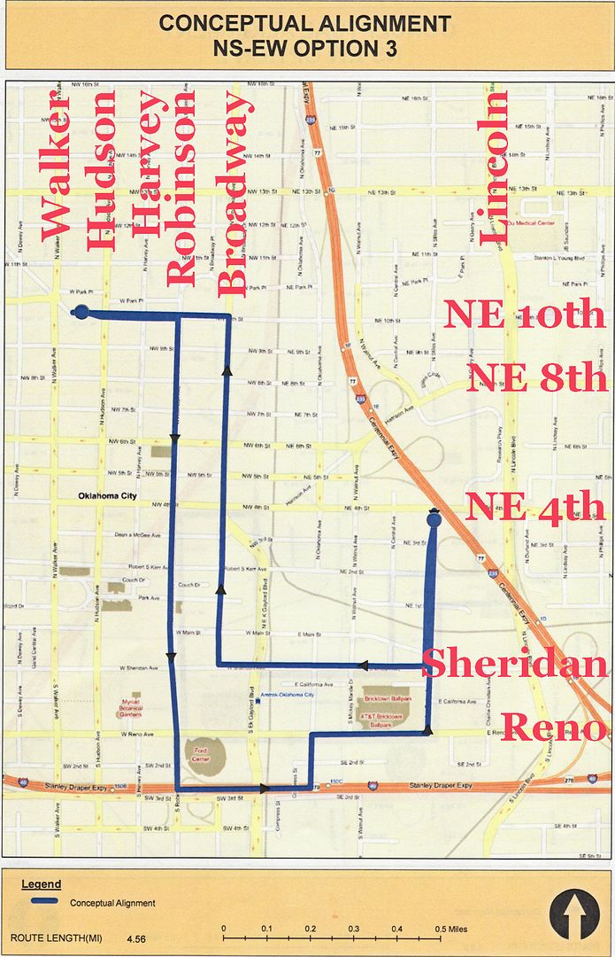
Bookmarks